FAA INFORMATION EFFECTIVE 16 APRIL 2026
Location
| FAA Identifier: | BTR |
| Lat/Long: | 30-31-58.5000N 091-08-59.6000W
30-31.975000N 091-08.993333W
30.5329167,-91.1498889
(estimated) |
| Elevation: | 69.7 ft. / 21.2 m (surveyed) |
| Variation: | 00E (2020) |
| From city: | 4 miles N of BATON ROUGE, LA |
| Time zone: | UTC -5 (UTC -6 during Standard Time) |
| Zip code: | 70807 |
Airport Operations
| Airport use: | Open to the public |
| Activation date: | 06/1942 |
| Control tower: | yes |
| ARTCC: | HOUSTON CENTER |
| FSS: | DE RIDDER FLIGHT SERVICE STATION |
| NOTAMs facility: | BTR (NOTAM-D service available) |
| Attendance: | 0500-0000 |
| Wind indicator: | lighted |
| Segmented circle: | yes |
| Lights: | ACTVT MALSR RYS 22R & 13 AND MALS RY 31 - CTAF. WHEN ATCT CLSD HIRL RYS 13/31 & 04L/22R PRESET LOW INTST; TO INCR INTST ACTVT - CTAF. MIRL RY 04R/22L NOT AVBL. |
| Beacon: | white-green (lighted land airport)
Operates sunset to sunrise. |
| Fire and rescue: | ARFF index C |
| Airline operations: | 24 HRS PPR FOR UNSKED ACR OPNS WITH MORE THAN 30 PSGR SEATS 0000-0500 CALL AMGR 225-355-2068/0333. |
| International operations: | customs landing rights airport |
Airport Communications
| CTAF: | 118.45 |
| UNICOM: | 122.95 |
| ATIS: | 125.2 |
| WX ASOS: | PHONE 225-370-8455 |
| RYAN GROUND: | 121.9 [0500-0000] |
| RYAN TOWER: | 118.45 257.8 [0500-0000] |
| BATON ROUGE APPROACH: | 120.3 ;WEST 133.225 ;EAST 278.3 [0500-0000] |
| BATON ROUGE DEPARTURE: | 120.3 ;WEST 133.225 ;EAST 278.3 [0500-0000] |
| CLEARANCE DELIVERY: | 119.4 |
| CLASS C: | 120.3 ;WEST 133.225 ;EAST 278.3 |
| EMERG: | 121.5 243.0 |
| IC: | 120.3 ;WEST |
- APCH/DEP SVC PRVDD BY HOUSTON ARTCC (ZHU) ON FREQS 126.35/338.25 (SLIDELL RCAG) WHEN BATON ROUGE APCH CLSD.
Nearby radio navigation aids
| VOR radial/distance | | VOR name | | Freq | | Var |
|---|
| LSUr063/8.0 | | FIGHTING TIGER VORTAC | | 116.50 | | 06E |
| RQRr311/39.5 | | RESERVE VOR/DME | | 110.80 | | 02E |
| NDB name | | Hdg/Dist | | Freq | | Var | | ID |
|---|
| RUNDI | | 133/4.4 | | 284 | | 00E | | BT | -... - |
Airport Services
| Fuel available: | 100LL JET-A |
| Parking: | hangars and tiedowns |
| Airframe service: | MAJOR |
| Powerplant service: | MAJOR |
| Bottled oxygen: | HIGH |
| Bulk oxygen: | HIGH |
Runway Information
Runway 4L/22R
| Dimensions: | 7500 x 150 ft. / 2286 x 46 m |
| Surface: | concrete/grooved, in excellent condition |
| Weight bearing capacity: | | Single wheel: | 120.0 | | Double wheel: | 170.0 | | Double tandem: | 300.0 |
|
| Runway edge lights: | high intensity |
| RUNWAY 4L | | RUNWAY 22R |
| Latitude: | 30-31.472600N | | 30-32.370527N |
| Longitude: | 091-09.445108W | | 091-08.461788W |
| Elevation: | 65.4 ft. | | 69.3 ft. |
| Traffic pattern: | left | | right |
| Runway heading: | 043 | | 223 |
| Declared distances: | TORA:7500 TODA:7500 ASDA:7500 LDA:7500 | | TORA:7500 TODA:7500 ASDA:7500 LDA:7500 |
| Markings: | nonprecision, in good condition | | precision, in good condition |
| Visual slope indicator: | | | 4-light PAPI on left (3.00 degrees glide path) |
| RVR equipment: | touchdown, rollout | | touchdown, rollout |
| Approach lights: | | | MALSR: 1,400 foot medium intensity approach lighting system with runway alignment indicator lights |
| Runway end identifier lights: | no | | |
| Centerline lights: | yes | | yes |
| Touchdown point: | yes, no lights | | yes, lighted |
| Instrument approach: | | | ILS/DME |
| Obstructions: | 52 ft. pole, lighted, 2200 ft. from runway, 125 ft. left of centerline, 38:1 slope to clear | | none |
Runway 13/31
| Dimensions: | 7005 x 150 ft. / 2135 x 46 m |
| Surface: | asphalt/grooved, in good condition |
| Weight bearing capacity: | | Single wheel: | 120.0 | | Double wheel: | 170.0 | | Double tandem: | 300.0 |
|
| Runway edge lights: | high intensity |
| RUNWAY 13 | | RUNWAY 31 |
| Latitude: | 30-32.444063N | | 30-31.649075N |
| Longitude: | 091-09.653972W | | 091-08.685270W |
| Elevation: | 65.9 ft. | | 69.0 ft. |
| Traffic pattern: | left | | left |
| Runway heading: | 133 | | 313 |
| Displaced threshold: | 597 ft. | | 314 ft. |
| Declared distances: | TORA:7004 TODA:7004 ASDA:6317 LDA:5720 | | TORA:7004 TODA:7004 ASDA:6407 LDA:6094 |
| Markings: | precision, in good condition | | nonprecision, in good condition |
| Visual slope indicator: | | | 4-box VASI on left (3.00 degrees glide path) |
| RVR equipment: | touchdown | | rollout |
| Approach lights: | MALSR: 1,400 foot medium intensity approach lighting system with runway alignment indicator lights | | MALS: 1,400 foot medium intensity approach lighting system |
| Touchdown point: | yes, no lights | | yes, no lights |
| Instrument approach: | ILS/DME | | |
| Obstructions: | 76 ft. pole, lighted, 2345 ft. from runway, 103 ft. right of centerline, 28:1 slope to clear
+7 FT FENCE 200 FT 406 FT LEFT. | | 11 ft. road, 230 ft. from runway, 503 ft. right of centerline, 2:1 slope to clear
+7 FT FENCE 200 FT 496 FT RIGHT. |
Runway 4R/22L
| Dimensions: | 3799 x 75 ft. / 1158 x 23 m |
| Surface: | asphalt, in fair condition |
| Weight bearing capacity: | | PCN 26 /F/C/X/T | | Single wheel: | 30.0 | | Double wheel: | 45.0 |
|
| Runway edge lights: | medium intensity |
| Operational restrictions: | RWY 04R/22L NOT AVBL FOR PART 121/PART 380 OPS WITH SKED PAX CARRYING OPS MORE THAN 9 PAX SEATS AND NON-SKED PAX CARRYING OPS MORE THAN 30 PAX SEATS. |
| RUNWAY 4R | | RUNWAY 22L |
| Latitude: | 30-31.718052N | | 30-32.172762N |
| Longitude: | 091-08.992645W | | 091-08.494445W |
| Elevation: | 66.5 ft. | | 68.3 ft. |
| Traffic pattern: | right | | left |
| Runway heading: | 043 | | 223 |
| Declared distances: | TORA:3799 TODA:3799 ASDA:3799 LDA:3799 | | TORA:3799 TODA:3799 ASDA:3799 LDA:3799 |
| Markings: | basic, in good condition | | basic, in good condition |
| Touchdown point: | yes, no lights | | yes, no lights |
Airport Ownership and Management from official FAA records
| Ownership: | Publicly-owned |
| Owner: | EAST BATON ROUGE PARISH
PO BOX 1471
BATON ROUGE, LA 70821
CITY OF BATON ROUGE AND PARISH OF EAST BATON ROUGE. |
| Manager: | MIKE EDWARDS
9430 JACKIE COCHRAN DR. STE 300
BATON ROUGE, LA 70807
Phone 225-355-0333 |
Additional Remarks
| A39-13/31 | PCR VALUE: 990/F/D/W/T |
| A39-04L/22R | PCR VALUE: 700/R/A/W/T |
| - | WHEN ATCT CLSD USE FREQ 121.9 TO CTC ARFF FOR EMERG REQ. |
| - | FOR CD IF UNA TO CTC ON FSS FREQ, CTC HOUSTON ARTCC AT 281-230-5622. |
| - | TWY E, TWY F BTN RWY 04R-22L AND AER 31 NOT AVBL FOR SKEDD ACR OPS. |
| - | TWY F BTN RWY 04R-22L AND AER 31 RDCS TO 40 FT WID. |
| - | DSGND FREE PUB USE PRKG FOR GA ACFT IN THE BACK ROW OF THE S RAMP. |
| - | MIGRATORY BIRDS ON & INVOF ARPT DURING MONTHS OF MAR/APR/SEP & OCT. |
| - | TWY E WEIGHT RESTRICTIONS: SINGLE 44,000 LBS; DUAL 55,000 LBS; DUAL TANDEM 93,000 LBS. |
| - | RAMP & TWY LANE ADJ TO THE COMMERICAL AIR CARRIER TERMINAL BLDG IS LMTD TO COMMERICAL AIR CARRIER AND PSGR AIRTAXI ACFT ONLY. |
| - | RWY 4R/22L AND TWY E ARE SIMILAR IN APPRNC. USE CTN WHEN EXITING RWY 13/31. |
Instrument Procedures
NOTE: All procedures below are presented as PDF files. If you need a reader for these files, you should download the free Adobe Reader.NOT FOR NAVIGATION. Please procure official charts for flight.
FAA instrument procedures published for use from 16 April 2026 at 0901Z to 14 May 2026 at 0900Z.
IAPs - Instrument Approach Procedures |
|---|
| ILS OR LOC RWY 13 | |
download (307KB) |
| ILS OR LOC/DME RWY 22R | |
download (294KB) |
| ILS RWY 22R (SA CAT I - II) | |
download (250KB) |
| RNAV (GPS) RWY 04L | |
download (280KB) |
| RNAV (GPS) RWY 13 | |
download (247KB) |
| RNAV (GPS) RWY 22R | |
download (281KB) |
| RNAV (GPS) RWY 31 | |
download (272KB) |
| VOR RWY 04L | |
download (301KB) |
| NOTE: Special Alternate Minimums apply | |
download (163KB) |
| NOTE: Special Take-Off Minimums/Departure Procedures apply | |
download (302KB) |
Other nearby airports with instrument procedures:
KHZR - False River Regional Airport (20 nm NW)
KREG - Louisiana Regional Airport (24 nm SE)
KHDC - Hammond Northshore Regional Airport (38 nm E)
KAPS - Port of South Louisiana Executive Regional Airport (40 nm SE)
KLFT - Lafayette Regional Airport/Paul Fournet Field (48 nm SW)
|
|

Road maps at:
MapQuest
Bing
Google
| Aerial photo |
|---|
WARNING: Photo may not be current or correct
 Photo by Jay Taffet / Gracen Aviation
Photo taken 03-Sep-2014
looking north.
Photo by Jay Taffet / Gracen Aviation
Photo taken 03-Sep-2014
looking north.
Do you have a better or more recent aerial photo of Baton Rouge Metropolitan Airport, Ryan Field that you would like to share? If so, please send us your photo.
|
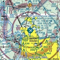
| Sectional chart |
|---|
|
CAUTION: Diagram may not be current
 Download PDF
of official airport diagram from the FAA
| Airport distance calculator |
|---|
|
|
| Sunrise and sunset |
|---|
|
Times for 28-Apr-2026
| | Local
(UTC-5) | | Zulu
(UTC) |
|---|
| Morning civil twilight | | 05:59 | | 10:59 |
| Sunrise | | 06:25 | | 11:25 |
| Sunset | | 19:40 | | 00:40 |
| Evening civil twilight | | 20:05 | | 01:05 |
|
| Current date and time |
|---|
| Zulu (UTC) | 28-Apr-2026 15:04:45 |
|---|
| Local (UTC-5) | 28-Apr-2026 10:04:45 |
|---|
|
| METAR |
|---|
| KBTR | 281453Z 18008KT 10SM BKN017 28/22 A3005 RMK AO2 SLP175 T02780222 53002
|
|
| TAF |
|---|
| KBTR | 281120Z 2812/2912 14003KT P6SM SCT019 SCT024 FM290900 18005KT P6SM BKN012 BKN070 FM291100 VRB04KT 5SM BR BKN006 BKN070
|
|
| NOTAMs |
|---|
NOTAMs are issued by the DoD/FAA and will open in a separate window not controlled by AirNav.
|
|


