FAA INFORMATION EFFECTIVE 14 MAY 2026
Location
| FAA Identifier: | HON |
| Lat/Long: | 44-23-06.7000N 098-13-42.8000W
44-23.111667N 098-13.713333W
44.3851944,-98.2285556
(estimated) |
| Elevation: | 1288.7 ft. / 392.8 m (surveyed) |
| Variation: | 07E (1985) |
| Time zone: | UTC -5 (UTC -6 during Standard Time) |
| Zip code: | 57350 |
Airport Operations
| Airport use: | Open to the public |
| Activation date: | 12/1937 |
| Control tower: | no |
| ARTCC: | MINNEAPOLIS CENTER |
| FSS: | HURON FLIGHT SERVICE STATION |
| NOTAMs facility: | HON (NOTAM-D service available) |
| Attendance: | 0700-SS
FOR ATTENDANT AFTER HRS CALL 605-352-9262. |
| Wind indicator: | lighted |
| Segmented circle: | yes |
| Lights: | HIRL RWY 12/30 PRESET ON LOW INTST SS-2200; TO INCR INTST & ACTVT MALSR RWY 12; REIL RWYS 18, 30, & 36; MIRL RWY 18/36 - CTAF. PAPI RWYS 12, 18, 30 & 36 OPER SR-2200; OTHER TIMES ACTVT - CTAF. |
| Beacon: | white-green (lighted land airport)
Operates sunset to sunrise. |
Airport Communications
| CTAF/UNICOM: | 123.0 |
| WX ASOS: | 118.125 (605-215-0039) |
- APCH/DEP SVC PRVDD BY MINNEAPOLIS ARTCC ON FREQS 126.25/339.8 (HURON RCAG).
- COMMUNICATIONS PRVDD BY HURON RADIO ON FREQ 122.2 (HURON RCO).
Nearby radio navigation aids
| VOR radial/distance | | VOR name | | Freq | | Var |
|---|
| MHEr343/37.4 | | MITCHELL VOR/DME | | 114.15 | | 04E |
| NDB name | | Hdg/Dist | | Freq | | Var | | ID |
|---|
| BEADY | | 120/5.8 | | 302 | | 07E | | HO | .... --- |
Airport Services
| Fuel available: | 100LL JET-A |
| Parking: | hangars and tiedowns |
| Airframe service: | MAJOR |
| Powerplant service: | MAJOR |
| Bottled oxygen: | LOW |
| Bulk oxygen: | NONE |
Runway Information
Runway 12/30
| Dimensions: | 7201 x 100 ft. / 2195 x 30 m |
| Surface: | concrete/grooved, in good condition |
| Weight bearing capacity: | | PCN 51 /R/B/W/T | | Single wheel: | 75.0 | | Double wheel: | 150.0 | | Double tandem: | 280.0 | | Dual double tandem: | 395.0 |
|
| Runway edge lights: | high intensity |
| RUNWAY 12 | | RUNWAY 30 |
| Latitude: | 44-23.544675N | | 44-22.813865N |
| Longitude: | 098-14.485400W | | 098-13.184502W |
| Elevation: | 1288.7 ft. | | 1283.3 ft. |
| Traffic pattern: | left | | left |
| Runway heading: | 121 magnetic, 128 true | | 301 magnetic, 308 true |
| Declared distances: | TORA:7201 TODA:7201 ASDA:7201 LDA:7201 | | TORA:7201 TODA:7201 ASDA:7201 LDA:7201 |
| Markings: | precision, in good condition | | precision, in good condition |
| Visual slope indicator: | 4-light PAPI on left (3.00 degrees glide path) | | 4-light PAPI on left (3.00 degrees glide path) |
| Approach lights: | MALSR: 1,400 foot medium intensity approach lighting system with runway alignment indicator lights | | |
| Runway end identifier lights: | | | yes |
| Touchdown point: | yes, no lights | | yes, no lights |
| Instrument approach: | ILS/DME | | |
| Obstructions: | none | | 23 ft. ant, 850 ft. from runway, 500 ft. right of centerline, 28:1 slope to clear |
Runway 18/36
| Dimensions: | 5000 x 75 ft. / 1524 x 23 m |
| Surface: | concrete, in good condition |
| Weight bearing capacity: | | PCN 11 /R/C/W/T | | Single wheel: | 40.0 | | Double wheel: | 55.0 |
|
| Runway edge lights: | medium intensity |
| RUNWAY 18 | | RUNWAY 36 |
| Latitude: | 44-23.426747N | | 44-22.603862N |
| Longitude: | 098-13.539597W | | 098-13.533113W |
| Elevation: | 1283.2 ft. | | 1284.9 ft. |
| Traffic pattern: | left | | left |
| Runway heading: | 173 magnetic, 180 true | | 353 magnetic, 360 true |
| Declared distances: | TORA:5000 TODA:5000 ASDA:5000 LDA:5000 | | TORA:5000 TODA:5000 ASDA:5000 LDA:5000 |
| Markings: | nonprecision, in good condition | | nonprecision, in good condition |
| Visual slope indicator: | 2-light PAPI on left (3.00 degrees glide path) | | 2-light PAPI on left (3.00 degrees glide path) |
| Runway end identifier lights: | yes | | yes |
| Touchdown point: | yes, no lights | | yes, no lights |
Airport Ownership and Management from official FAA records
| Ownership: | Publicly-owned |
| Owner: | CITY OF HURON
PO BOX 1369
HURON, SD 57350
Phone 605-353-8516 |
| Manager: | RICH BRAGG
PO BOX 1369
HURON, SD 57350
Phone 605-353-8516 |
Additional Remarks
| - | AGRICULTURAL ACFT SPRAYING INVOF ARPT APR-AUG. |
| - | FOR CD IF UNA TO CTC ON FSS FREQ, CTC MINNEAPOLIS ARTCC AT 651-463-5588. |
| - | SFC CONDS NOT MNTD 2000 TO 0600 LCL. |
Instrument Procedures
NOTE: All procedures below are presented as PDF files. If you need a reader for these files, you should download the free Adobe Reader.NOT FOR NAVIGATION. Please procure official charts for flight.
FAA instrument procedures published for use from 14 May 2026 at 0901Z to 11 June 2026 at 0900Z.
IAPs - Instrument Approach Procedures |
|---|
| ILS OR LOC RWY 12 | |
download (230KB) |
| RNAV (GPS) RWY 12 | |
download (216KB) |
| RNAV (GPS) RWY 30 | |
download (226KB) |
| LOC BC RWY 30 | |
download (204KB) |
| NOTE: Special Alternate Minimums apply | |
download (162KB) |
| NOTE: Special Take-Off Minimums/Departure Procedures apply | |
download (405KB) |
Other nearby airports with instrument procedures:
4X4 - Wessington Springs Airport (23 nm SW)
6E5 - Wilder Airport (29 nm E)
1D8 - Redfield Municipal Airport (31 nm NW)
KMKA - Miller Municipal Airport (32 nm W)
KMHE - Mitchell Municipal Airport (38 nm S)
|
|

Road maps at:
MapQuest
Bing
Google
| Aerial photo |
|---|
WARNING: Photo may not be current or correct
 Photo by Steve Hamilton
Photo taken 26-Apr-2006
Photo by Steve Hamilton
Photo taken 26-Apr-2006
Do you have a better or more recent aerial photo of Huron Regional Airport that you would like to share? If so, please send us your photo.
|
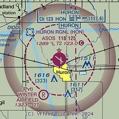
| Sectional chart |
|---|
|
CAUTION: Diagram may not be current

| Airport distance calculator |
|---|
|
|
| Sunrise and sunset |
|---|
|
Times for 07-Jun-2026
| | Local
(UTC-5) | | Zulu
(UTC) |
|---|
| Morning civil twilight | | 05:14 | | 10:14 |
| Sunrise | | 05:50 | | 10:50 |
| Sunset | | 21:13 | | 02:13 |
| Evening civil twilight | | 21:50 | | 02:50 |
|
| Current date and time |
|---|
| Zulu (UTC) | 07-Jun-2026 18:55:16 |
|---|
| Local (UTC-5) | 07-Jun-2026 13:55:16 |
|---|
|
| METAR |
|---|
| KHON | 071755Z AUTO 16012G27KT 10SM CLR 28/19 A2970 RMK AO2 PK WND 16027/1748 SLP046 T02830189 10289 20217 58006 $
|
|
| TAF |
|---|
| KHON | 071737Z 0718/0818 16015G30KT P6SM SCT040 SCT250 FM080000 14019G27KT P6SM BKN250 FM081300 16012G18KT P6SM BKN018 FM081600 18009KT P6SM BKN024
|
|
| NOTAMs |
|---|
NOTAMs are issued by the DoD/FAA and will open in a separate window not controlled by AirNav.
|
|


