FAA INFORMATION EFFECTIVE 14 MAY 2026
Location
| FAA Identifier: | MIT |
| Lat/Long: | 35-30-26.9200N 119-11-31.6700W
35-30.448667N 119-11.527833W
35.5074778,-119.1921306
(estimated) |
| Elevation: | 424.8 ft. / 129.5 m (surveyed) |
| Variation: | 13E (2010) |
| From city: | 4 miles E of SHAFTER, CA |
| Time zone: | UTC -7 (UTC -8 during Standard Time) |
| Zip code: | 93263 |
Airport Operations
| Airport use: | Open to the public |
| Activation date: | 03/1948 |
| Control tower: | no |
| ARTCC: | LOS ANGELES CENTER |
| FSS: | RANCHO MURIETA FLIGHT SERVICE STATION |
| NOTAMs facility: | RIU (NOTAM-D service available) |
| Attendance: | MON-FRI 0800-1700 |
| Wind indicator: | lighted |
| Segmented circle: | yes |
| Lights: | ACTVT REIL RWY 12 & 30; PAPI RWY 30; MIRL RWY 12/30 - CTAF. |
| Beacon: | white-green (lighted land airport)
Operates sunset to sunrise. |
Airport Communications
| CTAF: | 122.9 |
| WX AWOS-3: | 121.125 (661-393-8596) |
| BAKERSFIELD APPROACH: | 126.45 |
| BAKERSFIELD DEPARTURE: | 126.45 |
| WX ASOS at BFL (8 nm SE): | PHONE 661-246-3170 |
| WX AWOS-3P at DLO (14 nm N): | 119.55 (661-721-2668) |
- APCH/DEP CTL SVC PRVDD BY LOS ANGELES ARTCC (ZLA) ON FREQS 127.1/317.7 (BAKERSFIELD RCAG) WHEN BAKERSFIELD APCH CTL (BFL) CLSD.
Nearby radio navigation aids
| VOR radial/distance | | VOR name | | Freq | | Var |
|---|
| EHFr273/4.8 | | SHAFTER VORTAC | | 115.40 | | 14E |
| TTEr183/25.7 | | TULE VOR/DME | | 116.25 | | 16E |
| AVEr086/39.3 | | AVENAL VOR/DME | | 117.10 | | 16E |
| NDB name | | Hdg/Dist | | Freq | | Var | | ID |
|---|
| SALYER FARMS | | 138/37.4 | | 205 | | 16E | | COR | -.-. --- .-. |
Airport Services
| Fuel available: | 100LL JET-A |
| Parking: | tiedowns |
| Airframe service: | MAJOR |
| Powerplant service: | MAJOR |
| Bottled oxygen: | NONE |
| Bulk oxygen: | NONE |
Runway Information
Runway 12/30
| Dimensions: | 4501 x 100 ft. / 1372 x 30 m |
| Surface: | asphalt, in good condition |
| Weight bearing capacity: | |
| Runway edge lights: | medium intensity |
| RUNWAY 12 | | RUNWAY 30 |
| Latitude: | 35-30.640682N | | 35-30.131357N |
| Longitude: | 119-12.061502W | | 119-11.401837W |
| Elevation: | 412.5 ft. | | 412.2 ft. |
| Traffic pattern: | right | | left |
| Runway heading: | 120 magnetic, 133 true | | 300 magnetic, 313 true |
| Markings: | nonprecision, in good condition | | nonprecision, in good condition |
| Visual slope indicator: | | | 4-light PAPI on left (3.00 degrees glide path) |
| Runway end identifier lights: | yes | | yes |
| Touchdown point: | yes, no lights | | yes, no lights |
Runway 8/26
| Dimensions: | 3680 x 60 ft. / 1122 x 18 m |
| Surface: | asphalt, in good condition |
| Weight bearing capacity: | |
| RUNWAY 8 | | RUNWAY 26 |
| Latitude: | 35-30.634375N | | 35-30.633760N |
| Longitude: | 119-11.947838W | | 119-11.206038W |
| Elevation: | 413.7 ft. | | 424.6 ft. |
| Traffic pattern: | left | | right |
| Runway heading: | 077 magnetic, 090 true | | 257 magnetic, 270 true |
| Displaced threshold: | 140 ft. | | 166 ft. |
| Markings: | basic, in good condition | | basic, in good condition |
| Touchdown point: | yes, no lights | | yes, no lights |
| Obstructions: | 60 ft. trees, 1896 ft. from runway, 190 ft. right of centerline, 28:1 slope to clear
33:1 TO DSPLCD THLD. | | 20 ft. bldg, 411 ft. from runway, 10:1 slope to clear
28:1 TO THE DSPLCD THLD. |
Runway 17/35
| Dimensions: | 2972 x 100 ft. / 906 x 30 m |
| Surface: | concrete, in good condition |
| Weight bearing capacity: | | Single wheel: | 25.0 | | Double wheel: | 30.0 |
|
| RUNWAY 17 | | RUNWAY 35 |
| Latitude: | 35-30.558863N | | 35-30.068993N |
| Longitude: | 119-11.158175W | | 119-11.158622W |
| Elevation: | 423.1 ft. | | 414.3 ft. |
| Traffic pattern: | right | | left |
| Runway heading: | 167 magnetic, 180 true | | 347 magnetic, 000 true |
| Markings: | basic, in good condition | | basic, in good condition |
| Runway end identifier lights: | no | | no |
| Touchdown point: | yes, no lights | | yes, no lights |
| Obstructions: | 15 ft. road, 850 ft. from runway, 190 ft. left of centerline, 43:1 slope to clear | | 15 ft. road, 470 ft. from runway, 18:1 slope to clear |
Airport Ownership and Management from official FAA records
| Ownership: | Publicly-owned |
| Owner: | MINTER FIELD AIRPORT DISTRICT
201 AVIATION ST
SHAFTER, CA 93263
Phone 661-393-0402
AFTER HOURS 661-303-6996 |
| Manager: | JONATHAN HUDSON
201 AVIATION ST
SHAFTER, CA 93263
Phone (661) 303-6996 |
Additional Remarks
| - | FUEL 24 HR CREDIT CARD SVC AVBL. |
| - | ULTRALIGHT ACTIVITY ON & INVOF ARPT. |
| - | RY 30 PREFERRED CALM WIND RY. |
| - | RYS 26 AND 08 USED EXTENSIVELY BY AERIAL APPLICATOR ACFT. RECOMMEND EXTENSIVE USAGE OF CTAF FOR POSITION REPORTING. |
| - | FOR CD CTC LOS ANGELES ARTCC AT 661-575-2079. |
Instrument Procedures
NOTE: All procedures below are presented as PDF files. If you need a reader for these files, you should download the free Adobe Reader.NOT FOR NAVIGATION. Please procure official charts for flight.
FAA instrument procedures published for use from 14 May 2026 at 0901Z to 11 June 2026 at 0900Z.
IAPs - Instrument Approach Procedures |
|---|
| RNAV (GPS) RWY 12 | |
download (233KB) |
| VOR-A | |
download (208KB) |
| NOTE: Special Take-Off Minimums/Departure Procedures apply | |
download (351KB) |
Other nearby airports with instrument procedures:
KBFL - Meadows Field Airport (8 nm SE)
KDLO - Delano Municipal Airport (14 nm N)
L45 - Bakersfield Municipal Airport (15 nm SE)
KPTV - Porterville Municipal Airport (32 nm N)
KTLR - Mefford Field Airport (39 nm N)
|
|

Road maps at:
MapQuest
Bing
Google
| Aerial photo |
|---|
WARNING: Photo may not be current or correct
 Photo by Mike Evans
Photo taken 12-May-2009
Photo by Mike Evans
Photo taken 12-May-2009
Do you have a better or more recent aerial photo of Shafter Airport-Minter Field that you would like to share? If so, please send us your photo.
|
| Sectional chart |
|---|
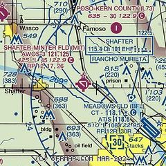
|
| Airport distance calculator |
|---|
|
|
| Sunrise and sunset |
|---|
|
Times for 22-May-2026
| | Local
(UTC-7) | | Zulu
(UTC) |
|---|
| Morning civil twilight | | 05:19 | | 12:19 |
| Sunrise | | 05:48 | | 12:48 |
| Sunset | | 19:59 | | 02:59 |
| Evening civil twilight | | 20:28 | | 03:28 |
|
| Current date and time |
|---|
| Zulu (UTC) | 22-May-2026 09:52:16 |
|---|
| Local (UTC-7) | 22-May-2026 02:52:16 |
|---|
|
| METAR |
|---|
KBFL
8nm SE | 220854Z AUTO 03005KT 10SM CLR 22/03 A2978 RMK AO2 SLP077 T02170033 50003
|
KDLO
14nm N | 220935Z AUTO 00000KT 10SM CLR 15/08 A2977 RMK AO2 T01490076
|
|
| TAF |
|---|
KBFL
8nm SE | 220520Z 2206/2306 34005KT P6SM SKC FM222200 31011G20KT P6SM SKC
|
|
| NOTAMs |
|---|
NOTAMs are issued by the DoD/FAA and will open in a separate window not controlled by AirNav.
|
|

