FAA INFORMATION EFFECTIVE 27 NOVEMBER 2025
Location
| FAA Identifier: | KOA |
| Lat/Long: | 19-44-19.5540N 156-02-44.2720W
19-44.325900N 156-02.737867W
19.7387650,-156.0456311
(estimated) |
| Elevation: | 50.5 ft. / 15 m (estimated) |
| Variation: | 11E (1985) |
| From city: | 6 miles NW of KAILUA-KONA, HI |
| Time zone: | UTC -10 (year round; does not observe DST) |
| Zip code: | 96740 |
Airport Operations
| Airport use: | Open to the public |
| Activation date: | 01/1971 |
| Control tower: | yes |
| ARTCC: | HONOLULU CONTROL FACILITY CENTER |
| FSS: | HONOLULU FLIGHT SERVICE STATION |
| NOTAMs facility: | KOA (NOTAM-D service available) |
| Attendance: | 0600-2200 |
| Wind indicator: | lighted |
| Segmented circle: | yes |
| Lights: | WHEN ATCT CLSD ACTVT MALSR RWY 17; HIRL RWY 17/35; TWY LGTS - CTAF. |
| Beacon: | white-green (lighted land airport)
Operates sunset to sunrise. |
| Fire and rescue: | ARFF index D |
| International operations: | customs landing rights airport |
Airport Communications
| CTAF: | 120.3 |
| ATIS: | 127.4 |
| WX ASOS: | PHONE 808-329-0412 |
| KONA GROUND: | 121.9 [0600-2200] |
| KONA TOWER: | 120.3 254.3 [0600-2200] |
| CLEARANCE DELIVERY: | 118.6 |
| EMERG: | 121.5 243.0 |
- APCH/DEP SVC PRVDD BY HONOLULU CONTROL FACILITY (ZHN) ON FREQS 118.45 (HALEAKALA)/278.3 (MOUNT HALEAKALA RCAG).
Nearby radio navigation aids
| VOR radial/distance | | VOR name | | Freq | | Var |
|---|
| KOAr347/1.3 | | KONA VORTAC | | 112.10 | | 11E |
| MUEr223/26.3 | | KAMUELA VOR/DME | | 113.30 | | 11E |
| UPPr191/30.0 | | UPOLU POINT VORTAC | | 112.30 | | 11E |
Airport Services
| Fuel available: | 100 JET-A
100:JET-A & 100 OCTANE FUEL AVBL DAILY 0800-1700, OTHER TIMES WITH PRIOR ARRANGMENTS, CALL 808-329-4682. |
| Parking: | tiedowns |
| Airframe service: | NONE |
| Powerplant service: | MINOR |
| Bottled oxygen: | NONE |
| Bulk oxygen: | NONE |
Runway Information
Runway 17/35
| Dimensions: | 11000 x 150 ft. / 3353 x 46 m |
| Surface: | asphalt/grooved, in good condition |
| Weight bearing capacity: | | PCN 69 /F/A/W/T | | Single wheel: | 75.0 | | Double wheel: | 200.0 | | Double tandem: | 400.0 | | Dual double tandem: | 850.0, DOUBLE DUAL TANDEM WHEEL FOR DC10-10 450000 LBS GWT; B747-SP 700000 LBS GWT; B747-100 850000 LBS GWT. |
|
| Runway edge lights: | high intensity |
| RUNWAY 17 | | RUNWAY 35 |
| Latitude: | 19-45.231315N | | 19-43.420483N |
| Longitude: | 156-02.657318W | | 156-02.818415W |
| Elevation: | 50.5 ft. | | 39.7 ft. |
| Traffic pattern: | right | | left |
| Runway heading: | 174 magnetic, 185 true | | 354 magnetic, 005 true |
| Declared distances: | TORA:11000 TODA:11000 ASDA:11000 LDA:11000 | | TORA:11000 TODA:11000 ASDA:11000 LDA:11000 |
| Markings: | precision, in good condition | | precision, in good condition |
| Visual slope indicator: | 4-light PAPI on right (3.00 degrees glide path) | | 4-light PAPI on left (3.00 degrees glide path) |
| Approach lights: | MALSR: 1,400 foot medium intensity approach lighting system with runway alignment indicator lights | | |
| Runway end identifier lights: | yes | | no |
| Touchdown point: | yes, no lights | | yes, no lights |
| Instrument approach: | ILS/DME | | |
| Obstructions: | 6 ft. other, 400 ft. from runway, 400 ft. left of centerline, 25:1 slope to clear
TERRAIN | | none |
Airport Ownership and Management from official FAA records
| Ownership: | Publicly-owned |
| Owner: | HAWAII ST ARPTS DIV
HONOLULU INTL ARPT, 300 RODGERS BOULEVARD, STE. 700
HONOLULU, HI 96819
Phone 808-838-8600 |
| Manager: | CHAUNCEY WONG YUEN
73-200 KUPIPI ST, KONA INTL AIRPORT AT KEAHOLE
KAILUA-KONA, HI 96740-2645
Phone 808-327-9520 |
Additional Remarks
| - | MIGRATORY BIRD ACTIVITY WITHIN A 5 NM RADIUS OF ARPT. |
| - | ALL WIDE-BODY AIRCRAFT CONTACT ATCT PRIOR TO ENGINE START. |
| - | DIVISION 1.1, 1.2, 1.3 EXPLOSIVES PROHIBITED. PPR FM ARPT MGR FOR TRANSPORTATION OF DIVISION 1.4 EXPLOSIVES AND HAZARDOUS MATERIAL IN AND OUT OF AIRPORT. |
| - | JET ACFT ON CARGO AND SOUTH RAMP CTC ATCT PRIOR TO ENGINE START. |
| - | U.S. CUSTOMS LCTD ON SOUTH RAMP. |
| - | PUSH BACK/PULL OUT REQUIRED FROM TERMINAL PARKING POSITIONS FOR ALL ACFT, NO POWER OUT. |
| - | HELICOPTER OPERATIONS ON AND INVOF TWY ALPHA. |
| - | FOR CD WHEN ATCT IS CLSD CTC HONOLULU CONTROL FACILITY AT 808-840-6262. |
| - | AP ARFF MNT CTAF 120.3 WHEN ATC CLSD. |
| - | TPA SMALL ACFT 800' MSL; LARGE ACFT 1500' MSL. |
| - | REQ FOUR ENG ACFT TAXI WITH OUTBOARD ENGS AT IDLE DUE NARROW TWYS. |
| - | ALL HELICOPTERS CONFINE OPNS TO PAVED AREAS. |
| - | PPR FM AMGR FOR TRANSIENT PARKING CALL 808-327-9520. |
Instrument Procedures
NOTE: All procedures below are presented as PDF files. If you need a reader for these files, you should download the free Adobe Reader.NOT FOR NAVIGATION. Please procure official charts for flight.
FAA instrument procedures published for use from 27 November 2025 at 0901Z to 25 December 2025 at 0900Z.
STARs - Standard Terminal Arrivals |
|---|
| KAYAK SIX | |
2 pages:
[1] [2] (319KB) |
| VECKI NINE | |
2 pages:
[1] [2] (318KB) |
IAPs - Instrument Approach Procedures |
|---|
| ILS OR LOC RWY 17 **CHANGED** | |
download (325KB) |
| RNAV (RNP) Z RWY 17 **CHANGED** | |
download (255KB) |
| RNAV (GPS) RWY 35 **CHANGED** | |
download (220KB) |
| RNAV (GPS) Y RWY 17 **CHANGED** | |
download (320KB) |
| VOR OR TACAN RWY 17 **CHANGED** | |
download (290KB) |
| VOR OR TACAN RWY 35 **CHANGED** | |
download (224KB) |
| NOTE: Special Alternate Minimums apply **CHANGED** | |
download (118KB) |
Departure Procedures |
|---|
| AMERY FOUR | |
download (162KB) |
| CRISI TWO (RNAV) | |
download (115KB) |
| ONIZU ONE (RNAV) | |
download (198KB) |
| NOTE: Special Take-Off Minimums/Departure Procedures apply | |
download (197KB) |
Other nearby airports with instrument procedures:
PHMU - Waimea-Kohala Airport (26 nm NE)
PHSF - Bradshaw Army Airfield (28 nm E)
PHTO - Hilo International Airport (56 nm E)
PHHN - Hana Airport (63 nm N)
PHOG - Kahului Airport (73 nm N)
|
|

Road maps at:
MapQuest
Bing
Google
| Aerial photo |
|---|
WARNING: Photo may not be current or correct
 Photo courtesy of longbachnguyen.com
Photo taken 13-Feb-2010
Photo courtesy of longbachnguyen.com
Photo taken 13-Feb-2010
Do you have a better or more recent aerial photo of Ellison Onizuka Kona International Airport at Keahole that you would like to share? If so, please send us your photo.
|
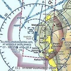
| Sectional chart |
|---|
|
CAUTION: Diagram may not be current
 Download PDF
of official airport diagram from the FAA
| Airport distance calculator |
|---|
|
|
| Sunrise and sunset |
|---|
|
Times for 29-Nov-2025
| | Local
(UTC-10) | | Zulu
(UTC) |
|---|
| Morning civil twilight | | 06:19 | | 16:19 |
| Sunrise | | 06:42 | | 16:42 |
| Sunset | | 17:43 | | 03:43 |
| Evening civil twilight | | 18:07 | | 04:07 |
|
| Current date and time |
|---|
| Zulu (UTC) | 30-Nov-2025 05:07:16 |
|---|
| Local (UTC-10) | 29-Nov-2025 19:07:16 |
|---|
|
| METAR |
|---|
| PHKO | 300453Z 01008KT 10SM CLR 26/21 A3001 RMK AO2 SLP162 T02560206 $
|
|
| TAF |
|---|
| PHKO | 300301Z 3003/0106 32010KT P6SM SCT050 FM300600 VRB05KT P6SM FEW050 FM302100 23008KT P6SM SCT020
|
|
| NOTAMs |
|---|
NOTAMs are issued by the DoD/FAA and will open in a separate window not controlled by AirNav.
|
|


