FAA INFORMATION EFFECTIVE 14 MAY 2026
Location
| FAA Identifier: | RZT |
| Lat/Long: | 39-26-25.5000N 083-01-23.0000W
39-26.425000N 083-01.383333W
39.4404167,-83.0230556
(estimated) |
| Elevation: | 725 ft. / 221.0 m (surveyed) |
| Variation: | 05W (1985) |
| From city: | 6 miles NW of CHILLICOTHE, OH |
| Time zone: | UTC -4 (UTC -5 during Standard Time) |
| Zip code: | 45601 |
Airport Operations
| Airport use: | Open to the public |
| Activation date: | 02/1965 |
| Control tower: | no |
| ARTCC: | INDIANAPOLIS CENTER |
| FSS: | DAYTON FLIGHT SERVICE STATION |
| NOTAMs facility: | RZT (NOTAM-D service available) |
| Attendance: | 0800-1700
UNATNDD NEW YEARS, JULY 4TH, THANKSGIVING, & CHRISTMAS. |
| Wind indicator: | lighted |
| Segmented circle: | yes |
| Lights: | ACTVT REIL RWY 05 & 23; PAPI RWY 05 & 23; MIRL RWY 05/23 - 123.0. |
| Beacon: | white-green (lighted land airport)
Operates sunset to sunrise. |
Airport Communications
| CTAF/UNICOM: | 122.8 |
| WX AWOS-3: | 119.225 (740-779-1364) |
| COLUMBUS APPROACH: | 134.0 132.3 ;100-279 |
| COLUMBUS DEPARTURE: | 134.0 132.3 ;100-279 |
| CLASS C/S: | 132.3 ;100-279 |
| IC: | 134.0 |
| WX AWOS-3PT at EOP (17 nm S): | 121.45 (740-947-0035) |
| WX AWOS-3PT at I23 (20 nm NW): | 132.1 (740-620-2255) |
Nearby radio navigation aids
| VOR radial/distance | | VOR name | | Freq | | Var |
|---|
| XUBr207/(5.6) | | YELLOW BUD VOR | | 112.50 | | 05W |
| MXQr093/36.1 | | MIDWEST VOR/DME | | 112.90 | | 04W |
| NDB name | | Hdg/Dist | | Freq | | Var | | ID |
|---|
| COURT HOUSE | | 125/19.6 | | 414 | | 06W | | CSS | -.-. ... ... |
Airport Services
| Fuel available: | 100LL JET-A |
| Parking: | hangars and tiedowns |
| Airframe service: | MINOR |
| Powerplant service: | MINOR |
| Bottled oxygen: | NONE |
| Bulk oxygen: | NONE |
Runway Information
Runway 5/23
| Dimensions: | 5405 x 100 ft. / 1647 x 30 m |
| Surface: | asphalt, in fair condition |
| Weight bearing capacity: | | Single wheel: | 75.0 | | Double wheel: | 100.0 |
|
| Runway edge lights: | medium intensity |
| RUNWAY 5 | | RUNWAY 23 |
| Latitude: | 39-26.096358N | | 39-26.753453N |
| Longitude: | 083-01.771055W | | 083-00.996345W |
| Elevation: | 724.9 ft. | | 704.5 ft. |
| Traffic pattern: | left | | left |
| Runway heading: | 047 magnetic, 042 true | | 227 magnetic, 222 true |
| Markings: | nonprecision, in fair condition | | nonprecision, in fair condition |
| Visual slope indicator: | 4-light PAPI on left (3.00 degrees glide path) | | 4-light PAPI on left (3.00 degrees glide path) |
| Runway end identifier lights: | yes | | yes |
| Touchdown point: | yes, no lights | | yes, no lights |
| Obstructions: | 70 ft. trees, 1411 ft. from runway, 345 ft. left of centerline, 17:1 slope to clear | | 41 ft. trees, 1216 ft. from runway, 345 ft. left of centerline, 24:1 slope to clear |
Airport Ownership and Management from official FAA records
| Ownership: | Publicly-owned |
| Owner: | ROSS COUNTY BOARD OF COMM
2 N PAINT ST STE H
CHILLICOTHE, OH 45601-3109
Phone 740-702-3085 |
| Manager: | DANNY CASH, INTERIM AMGR
1296 STONE RD
CHILLICOTHE, OH 45601-9739
Phone 740-773-4788
OR 800-764-3445. |
Additional Remarks
| - | FOR CD CTC COLUMBUS APCH AT 614-338-8537. |
Instrument Procedures
NOTE: All procedures below are presented as PDF files. If you need a reader for these files, you should download the free Adobe Reader.NOT FOR NAVIGATION. Please procure official charts for flight.
FAA instrument procedures published for use from 14 May 2026 at 0901Z to 11 June 2026 at 0900Z.
IAPs - Instrument Approach Procedures |
|---|
| RNAV (GPS) RWY 23 | |
download (263KB) |
| VOR RWY 23 | |
download (210KB) |
| NOTE: Special Alternate Minimums apply | |
download (143KB) |
| NOTE: Special Take-Off Minimums/Departure Procedures apply | |
download (164KB) |
Other nearby airports with instrument procedures:
KCYO - Pickaway County Memorial Airport (5 nm NE)
KEOP - Pike County Airport (17 nm S)
I23 - Fayette County Airport (20 nm NW)
KLCK - Rickenbacker International Airport (23 nm N)
KLHQ - Fairfield County Airport (25 nm NE)
|
|

Road maps at:
MapQuest
Bing
Google
| Aerial photo |
|---|
WARNING: Photo may not be current or correct
 Photo by Nick Green
Photo taken 26-Dec-2011
looking northeast.
Photo by Nick Green
Photo taken 26-Dec-2011
looking northeast.
Do you have a better or more recent aerial photo of Ross County Airport that you would like to share? If so, please send us your photo.
|
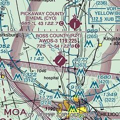
| Sectional chart |
|---|
|
| Airport distance calculator |
|---|
|
|
| Sunrise and sunset |
|---|
|
Times for 17-May-2026
| | Local
(UTC-4) | | Zulu
(UTC) |
|---|
| Morning civil twilight | | 05:47 | | 09:47 |
| Sunrise | | 06:17 | | 10:17 |
| Sunset | | 20:40 | | 00:40 |
| Evening civil twilight | | 21:10 | | 01:10 |
|
| Current date and time |
|---|
| Zulu (UTC) | 17-May-2026 13:39:16 |
|---|
| Local (UTC-4) | 17-May-2026 09:39:16 |
|---|
|
| METAR |
|---|
| KRZT | 171255Z AUTO 17005KT 10SM BKN120 18/18 A3014 RMK AO2 PWINO
|
KEOP
17nm S | 171315Z AUTO 00000KT 10SM CLR 19/19 A3013 RMK AO2
|
KI23
20nm NW | 171315Z AUTO 19009KT 10SM CLR 21/19 A3011 RMK AO2
|
|
| TAF |
|---|
KLCK
23nm N | 171120Z 1712/1812 16005KT P6SM BKN060 TEMPO 1712/1713 3SM -TSRA BR OVC025CB FM171300 19008KT P6SM BKN150 FM171600 21010G18KT P6SM SCT050 FM180000 18005KT P6SM SKC
|
|
| NOTAMs |
|---|
NOTAMs are issued by the DoD/FAA and will open in a separate window not controlled by AirNav.
|
|


