FAA INFORMATION EFFECTIVE 19 MARCH 2026
Location
| FAA Identifier: | TQK |
| Lat/Long: | 38-28-30.0830N 100-53-03.9800W
38-28.501383N 100-53.066333W
38.4750231,-100.8844389
(estimated) |
| Elevation: | 2968.7 ft. / 904.9 m (surveyed) |
| Variation: | 08E (1995) |
| From city: | 1 mile SE of SCOTT CITY, KS |
| Time zone: | UTC -5 (UTC -6 during Standard Time) |
| Zip code: | 67871 |
Airport Operations
| Airport use: | Open to the public |
| Activation date: | 12/1945 |
| Control tower: | no |
| ARTCC: | DENVER CENTER |
| FSS: | WICHITA FLIGHT SERVICE STATION |
| NOTAMs facility: | ICT (NOTAM-D service available) |
| Attendance: | 0800-1730 |
| Wind indicator: | lighted |
| Segmented circle: | yes |
| Lights: | MIRL RWY 17/35 PRESET LOW INTST; TO INCR INTST & ACTVT REIL, PAPI RWYS 17 & 35 - CTAF. |
| Beacon: | white-green (lighted land airport)
Operates sunset to sunrise. |
Airport Communications
| CTAF/UNICOM: | 122.8 |
| WX AWOS-3P: | 120.00 (620-872-2233) |
- APCH/DEP CTL SVC PRVDD BY DENVER ARTCC (ZDV) ON FREQS 132.7/226.675 (GOODLAND RCAG).
Nearby radio navigation aids
| VOR radial/distance | | VOR name | | Freq | | Var |
|---|
| GCKr336/34.2 | | GARDEN CITY VORTAC | | 113.30 | | 11E |
Airport Services
| Fuel available: | 100LL JET-A |
| Parking: | hangars and tiedowns |
| Airframe service: | MAJOR |
| Powerplant service: | MAJOR |
| Bottled oxygen: | NONE |
| Bulk oxygen: | NONE |
Runway Information
Runway 17/35
| Dimensions: | 5002 x 75 ft. / 1525 x 23 m |
| Surface: | concrete, in excellent condition |
| Weight bearing capacity: | | PCN 11 /R/C/X/U | | Single wheel: | 30.0 | | Double wheel: | 45.0 |
|
| Runway edge lights: | medium intensity |
| RUNWAY 17 | | RUNWAY 35 |
| Latitude: | 38-28.869487N | | 38-28.045573N |
| Longitude: | 100-53.101735W | | 100-53.089838W |
| Elevation: | 2959.7 ft. | | 2956.1 ft. |
| Traffic pattern: | left | | left |
| Runway heading: | 171 magnetic, 179 true | | 351 magnetic, 359 true |
| Markings: | nonprecision, in fair condition | | nonprecision, in fair condition |
| Visual slope indicator: | 2-light PAPI on left (3.00 degrees glide path) | | 2-light PAPI on left (3.00 degrees glide path) |
| Runway end identifier lights: | yes | | yes |
| Touchdown point: | yes, no lights | | yes, no lights |
| Obstructions: | 15 ft. road, 530 ft. from runway, 22:1 slope to clear
CONTROLLING OBSTN EXCEEDS A 45 DEG SLP. | | 10 ft. road, 201 ft. from runway, 283 ft. right of centerline |
Runway 8/26
| Dimensions: | 2145 x 60 ft. / 654 x 18 m |
| Surface: | turf, in good condition
ROUGH, WITH MULTIPLE RODENT HOLES. |
| Runway edge markings: | 08/26 MKD WITH PAINTED TIRES. |
| RUNWAY 8 | | RUNWAY 26 |
| Latitude: | 38-28.604663N | | 38-28.602625N |
| Longitude: | 100-53.222353W | | 100-52.772960W |
| Elevation: | 2960.3 ft. | | 2968.6 ft. |
| Traffic pattern: | left | | left |
| Runway heading: | 082 magnetic, 090 true | | 262 magnetic, 270 true |
| Touchdown point: | yes, no lights | | yes, no lights |
Airport Ownership and Management from official FAA records
| Ownership: | Publicly-owned |
| Owner: | CITY OF SCOTT CITY
221 W. 5TH
SCOTT CITY, KS 67871
Phone 620-872-5322 |
| Manager: | WARREN HARKNESS
300 SOUTH MESQUITE ROAD
SCOTT CITY, KS 67871
Phone (620) 872-5620 |
Additional Remarks
| - | PUB TELEPHONE AVBL 24 HRS 620-872-5378 |
| - | NUMEROUS BIRDS INVOF ARPT. |
| - | FOR CD CTC DENVER ARTCC AT 303-651-4257. |
Instrument Procedures
NOTE: All procedures below are presented as PDF files. If you need a reader for these files, you should download the free Adobe Reader.NOT FOR NAVIGATION. Please procure official charts for flight.
FAA instrument procedures published for use from 19 March 2026 at 0901Z to 16 April 2026 at 0900Z.
IAPs - Instrument Approach Procedures |
|---|
| RNAV (GPS) RWY 17 | |
download (196KB) |
| RNAV (GPS) RWY 35 | |
download (223KB) |
| NOTE: Special Alternate Minimums apply | |
download (140KB) |
| NOTE: Special Take-Off Minimums/Departure Procedures apply | |
download (324KB) |
Other nearby airports with instrument procedures:
3K7 - Mark Hoard Memorial Airport (22 nm W)
KGCK - Garden City Regional Airport (34 nm S)
KOEL - Oakley Municipal Airport (38 nm N)
5K2 - Tribune Municipal Airport (41 nm W)
1QK - Gove County Airport (45 nm NE)
|
|

Road maps at:
MapQuest
Bing
Google
| Aerial photo |
|---|
WARNING: Photo may not be current or correct
 Photo by Von Rothenberger and David Readio
Photo taken 18-Nov-2006
Photo by Von Rothenberger and David Readio
Photo taken 18-Nov-2006
Do you have a better or more recent aerial photo of Scott City Municipal Airport that you would like to share? If so, please send us your photo.
|
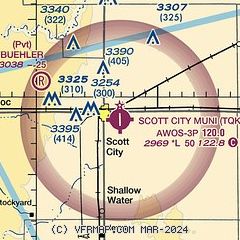
| Sectional chart |
|---|
|
| Airport distance calculator |
|---|
|
|
| Sunrise and sunset |
|---|
|
Times for 15-Apr-2026
| | Local
(UTC-5) | | Zulu
(UTC) |
|---|
| Morning civil twilight | | 06:41 | | 11:41 |
| Sunrise | | 07:09 | | 12:09 |
| Sunset | | 20:19 | | 01:19 |
| Evening civil twilight | | 20:46 | | 01:46 |
|
| Current date and time |
|---|
| Zulu (UTC) | 15-Apr-2026 05:25:42 |
|---|
| Local (UTC-5) | 15-Apr-2026 00:25:42 |
|---|
|
| METAR |
|---|
| KTQK | 150455Z AUTO 29015G20KT 10SM CLR 17/M07 A2973 RMK AO2 T01731075
|
|
| TAF |
|---|
KGCK
34nm S | 141720Z 1418/1518 24024G35KT P6SM SCT250 FM150100 23010KT P6SM SCT250 FM151500 29017G26KT P6SM SKC
|
|
| NOTAMs |
|---|
NOTAMs are issued by the DoD/FAA and will open in a separate window not controlled by AirNav.
|
|


