FAA INFORMATION EFFECTIVE 11 JUNE 2026
Location
| FAA Identifier: | LBR |
| Lat/Long: | 33-35-33.5050N 095-03-50.9300W
33-35.558417N 095-03.848833W
33.5926403,-95.0641472
(estimated) |
| Elevation: | 440 ft. / 134 m (estimated) |
| Variation: | 02E (2020) |
| From city: | 3 miles SW of CLARKSVILLE, TX |
| Time zone: | UTC -5 (UTC -6 during Standard Time) |
| Zip code: | 75426 |
Airport Operations
| Airport use: | Open to the public |
| Control tower: | no |
| ARTCC: | FORT WORTH CENTER |
| FSS: | FORT WORTH FLIGHT SERVICE STATION |
| NOTAMs facility: | LBR (NOTAM-D service available) |
| Attendance: | IREG |
| Wind indicator: | lighted |
| Segmented circle: | yes |
| Lights: | SS-SR |
| Beacon: | white-green (lighted land airport)
Operates sunset to sunrise. |
Airport Communications
| CTAF: | 122.9 |
| WX AWOS-3PT at PRX (19 nm W): | 119.675 (903-737-8784) |
Nearby radio navigation aids
| VOR radial/distance | | VOR name | | Freq | | Var |
|---|
| PRXr074/19.4 | | PARIS VOR/DME | | 113.60 | | 07E |
Airport Services
| Parking: | hangars and tiedowns |
| Airframe service: | NONE |
| Powerplant service: | NONE |
| Bottled oxygen: | NONE |
| Bulk oxygen: | NONE |
Runway Information
Runway 18/36
| Dimensions: | 3000 x 50 ft. / 914 x 15 m |
| Surface: | asphalt, in fair condition |
| Weight bearing capacity: | |
| Runway edge lights: | medium intensity |
| RUNWAY 18 | | RUNWAY 36 |
| Latitude: | 33-35.805833N | | 33-35.311000N |
| Longitude: | 095-03.853500W | | 095-03.844167W |
| Elevation: | 435.0 ft. | | 422.0 ft. |
| Traffic pattern: | left | | left |
| Runway heading: | 177 magnetic, 179 true | | 357 magnetic, 359 true |
| Markings: | basic, in good condition | | basic, in good condition |
| Touchdown point: | yes, no lights | | yes, no lights |
| Obstructions: | 35 ft. trees, 201 ft. from runway, 85 ft. right of centerline
23 FT TREES, 180-199 FT DSTC, 100 R. | | 44 ft. trees, 642 ft. from runway, 85 ft. left of centerline, 10:1 slope to clear |
Airport Ownership and Management from official FAA records
| Ownership: | Publicly-owned |
| Owner: | CLARKSVILLE-RED RIVER CO
400 N. WALNUT
CLARKSVILLE, TX 75426
Phone 903-427-0370 |
| Manager: | DAN HALLEY
550 S AUSTIN
AVERY, TX 75554
Phone 903-631-9531 |
Additional Remarks
| - | FOR CD CTC FORT WORTH ARTCC AT 817-858-7584. |
Instrument Procedures
There are no published instrument procedures at KLBR.
Some nearby airports with instrument procedures:
KPRX - Cox Field Airport (19 nm W)
4O4 - Mc Curtain County Regional Airport (22 nm NE)
F53 - Franklin County Airport (24 nm S)
KOSA - Mount Pleasant Regional Airport (30 nm S)
KHHW - Stan Stamper Municipal Airport (36 nm NW)
|
|

Road maps at:
MapQuest
Bing
Google
| Aerial photo |
|---|
WARNING: Photo may not be current or correct
 Photo taken 18-May-2020
looking east.
Photo taken 18-May-2020
looking east.
Do you have a better or more recent aerial photo of Clarksville/Red River County Airport-J D Trissell Field that you would like to share? If so, please send us your photo.
|
| Sectional chart |
|---|
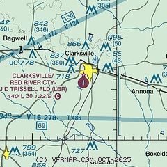
|
| Airport distance calculator |
|---|
|
|
| Sunrise and sunset |
|---|
|
Times for 12-Jun-2026
| | Local
(UTC-5) | | Zulu
(UTC) |
|---|
| Morning civil twilight | | 05:42 | | 10:42 |
| Sunrise | | 06:10 | | 11:10 |
| Sunset | | 20:30 | | 01:30 |
| Evening civil twilight | | 20:59 | | 01:59 |
|
| Current date and time |
|---|
| Zulu (UTC) | 12-Jun-2026 20:14:01 |
|---|
| Local (UTC-5) | 12-Jun-2026 15:14:01 |
|---|
|
| METAR |
|---|
KPRX
19nm W | 121955Z AUTO 08007KT 10SM FEW150 23/21 A2998 RMK AO2 PRESFR SLP148 T02280211 PNO
|
|
| NOTAMs |
|---|
NOTAMs are issued by the DoD/FAA and will open in a separate window not controlled by AirNav.
|
|

