FAA INFORMATION EFFECTIVE 19 MARCH 2026
Location
| FAA Identifier: | MO1 |
| Lat/Long: | 37-52-29.6000N 092-24-29.0000W
37-52.493333N 092-24.483333W
37.8748889,-92.4080556
(estimated) |
| Elevation: | 1110 ft. / 338.3 m (surveyed) |
| Variation: | 04E (1985) |
| From city: | 1 mile N of RICHLAND, MO |
| Time zone: | UTC -5 (UTC -6 during Standard Time) |
| Zip code: | 65556 |
Airport Operations
| Airport use: | Open to the public |
| Activation date: | 10/1970 |
| Control tower: | no |
| ARTCC: | KANSAS CITY CENTER |
| FSS: | COLUMBIA FLIGHT SERVICE STATION |
| NOTAMs facility: | COU (NOTAM-D service available) |
| Attendance: | UNATNDD |
| Wind indicator: | lighted |
| Segmented circle: | yes |
| Lights: | DUSK-DAWN. ACTVT LIRL RY 14/32 - CTAF. |
Airport Communications
| CTAF: | 122.9 |
| WX AWOS-3PT at OZS (15 nm NW): | 120.225 (573-233-1004) |
| WX AWOS-3PT at AIZ (15 nm NW): | 135.325 (573-348-0847) |
| WX ASOS at TBN (15 nm SE): | 118.7 |
| WX AWOS-3PT at LBO (18 nm SW): | 118.975 (417-533-3419) |
Nearby radio navigation aids
| VOR radial/distance | | VOR name | | Freq | | Var |
|---|
| SHYr137/13.5 | | SUNSHINE VOR/DME | | 108.40 | | 00E |
| TBNr302/(15.0) | | FORNEY VOR | | 110.00 | | 00E |
| VIHr237/37.1 | | VICHY VOR/DME | | 117.70 | | 06E |
Airport Services
| Bottled oxygen: | NONE |
| Bulk oxygen: | NONE |
Runway Information
Runway 14/32
| Dimensions: | 3000 x 60 ft. / 914 x 18 m |
| Surface: | asphalt, in good condition |
| Weight bearing capacity: | |
| Runway edge lights: | low intensity |
| RUNWAY 14 | | RUNWAY 32 |
| Latitude: | 37-52.681333N | | 37-52.306667N |
| Longitude: | 092-24.686167W | | 092-24.279333W |
| Elevation: | 1110.0 ft. | | 1110.0 ft. |
| Traffic pattern: | left | | left |
| Displaced threshold: | 170 ft. | | 130 ft. |
| Markings: | basic, in good condition | | basic, in good condition |
| Obstructions: | 40 ft. trees, 418 ft. from runway, 150 ft. left and right of centerline, 5:1 slope to clear
RWY 14 +40 FT TREES, 588 FT, 150FT L-R, 14:1 BASED ON DSPLCD THLD. | | 32 ft. trees, 202 ft. from runway, 125 ft. left and right of centerline
RWY 32 +1-6 FT GND; TREE, 35 FT, 55 FT FM RWY END 70 FT R; TREES 18-35 FT, 180-200 FT FM RWY END, L & R. |
Airport Ownership and Management from official FAA records
| Ownership: | Publicly-owned |
| Owner: | CITY OF RICHLAND
PO BOX 798
RICHLAND, MO 65556
Phone 573-765-4421 |
| Manager: | DANA TANNER
PO BOX 798
RICHLAND, MO 65556
Phone 573-765-3532
MAYOR |
Additional Remarks
| A96 | ULTRALIGHT ACTIVITY ON AND INVOF ARPT. |
| - | GOLFERS CROSSING RY APPROXIMATELY 800 FT NORTHWEST OF RY 32 THR. |
| - | WILDLIFE ON & INVOF ARPT. |
| - | FOR CD CTC KANSAS CITY ARTCC AT 913-254-8508. |
Instrument Procedures
There are no published instrument procedures at MO1.
Some nearby airports with instrument procedures:
KOZS - Camdenton Memorial-Lake Regional Airport (15 nm NW)
KAIZ - Lee C Fine Memorial Airport (15 nm NW)
KTBN - Waynesville-St. Robert Regional Airport-Forney Field (15 nm SE)
KLBO - Floyd W Jones Lebanon Airport (18 nm SW)
K15 - Grand Glaize-Osage Beach Airport (19 nm NW)
|
|

Road maps at:
MapQuest
Bing
Google
| Aerial photo |
|---|
WARNING: Photo may not be current or correct
 Photo taken 16-Mar-2019
looking northwest.
Photo taken 16-Mar-2019
looking northwest.
Do you have a better or more recent aerial photo of Richland Municipal Airport that you would like to share? If so, please send us your photo.
|
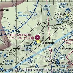
| Sectional chart |
|---|
|
| Airport distance calculator |
|---|
|
|
| Sunrise and sunset |
|---|
|
Times for 13-Apr-2026
| | Local
(UTC-5) | | Zulu
(UTC) |
|---|
| Morning civil twilight | | 06:11 | | 11:11 |
| Sunrise | | 06:38 | | 11:38 |
| Sunset | | 19:42 | | 00:42 |
| Evening civil twilight | | 20:09 | | 01:09 |
|
| Current date and time |
|---|
| Zulu (UTC) | 13-Apr-2026 14:44:13 |
|---|
| Local (UTC-5) | 13-Apr-2026 09:44:13 |
|---|
|
| METAR |
|---|
KOZS
15nm NW | 131435Z AUTO 21008G16KT 10SM OVC029 22/16 A3000 RMK AO2
|
KAIZ
15nm NW | 131356Z AUTO 20014KT 10SM OVC028 22/18 A2999 RMK AO2 SLP149 T02220178 $
|
KTBN
17nm SE | 131255Z AUTO 18007KT 10SM OVC027 21/17 A2998 RMK AO2 CIG 026 RWY33 SLP146 T02050169 $
|
KLBO
18nm SW | 131435Z AUTO 22014G20KT 10SM BKN023 OVC031 22/17 A3002 RMK AO2
|
|
| NOTAMs |
|---|
NOTAMs are issued by the DoD/FAA and will open in a separate window not controlled by AirNav.
|
|

