FAA INFORMATION EFFECTIVE 16 APRIL 2026
Location
| FAA Identifier: | MS95 |
| Lat/Long: | 33-50-50.4030N 090-43-30.3510W
33-50.840050N 090-43.505850W
33.8473342,-90.7250975
(estimated) |
| Elevation: | 142 ft. / 43 m (estimated) |
| Variation: | 03E (1985) |
| From city: | 1 mile N of MERIGOLD, MS |
| Time zone: | UTC -5 (UTC -6 during Standard Time) |
| Zip code: | 38759 |
Airport Operations
| Airport use: | Private use. Permission required prior to landing |
| Activation date: | 12/1974 |
| Control tower: | no |
| ARTCC: | MEMPHIS CENTER |
| FSS: | GREENWOOD FLIGHT SERVICE STATION |
| Attendance: | DAYLIGHT HOURS |
| Wind indicator: | yes |
| Segmented circle: | no |
Airport Communications
| WX AWOS-3PT at RNV (5 nm S): | 124.175 (662-843-3021) |
Nearby radio navigation aids
| VOR radial/distance | | VOR name | | Freq | | Var |
|---|
| GLHr030/23.3 | | GREENVILLE VOR/DME | | 114.25 | | 04E |
| SQSr313/32.1 | | SIDON VORTAC | | 114.70 | | 03E |
| NDB name | | Hdg/Dist | | Freq | | Var | | ID |
|---|
| METCALF | | 028/28.4 | | 359 | | 01W | | MTQ | -- - --.- |
Airport Services
| Parking: | hangars and tiedowns |
| Airframe service: | NONE |
| Powerplant service: | NONE |
| Bottled oxygen: | NONE |
| Bulk oxygen: | NONE |
Runway Information
Runway 9/27
| Dimensions: | 2800 x 200 ft. / 853 x 61 m |
| Surface: | turf, in poor condition |
| RUNWAY 9 | | RUNWAY 27 |
| Traffic pattern: | right | | left |
| Obstructions: | 25 ft. pole, 125 ft. from runway, 5:1 slope to clear | | 42 ft. trees, 300 ft. from runway, 7:1 slope to clear |
Runway 16/34
| Dimensions: | 2000 x 100 ft. / 610 x 30 m |
| Surface: | turf, in fair condition |
| RUNWAY 16 | | RUNWAY 34 |
| Traffic pattern: | right | | left |
| Obstructions: | 60 ft. tree, 200 ft. from runway, 25 ft. left of centerline, 3:1 slope to clear | | 53 ft. trees, 600 ft. from runway, 15 ft. right of centerline, 11:1 slope to clear
+3' STOCK FENCE. |
Runway 18/36
| Dimensions: | 1800 x 100 ft. / 549 x 30 m |
| Surface: | turf, in fair condition |
| RUNWAY 18 | | RUNWAY 36 |
| Traffic pattern: | left | | left |
| Obstructions: | 6 ft. road, 100 ft. from runway, 16:1 slope to clear | | 48 ft. trees, 150 ft. from runway, 3:1 slope to clear
+3' STOCK FENCE. |
Airport Ownership and Management from official FAA records
| Ownership: | Privately-owned |
| Owner: | GERALDINE F. LOGAN
PO BOX 1567
CLEVELAND, MS 38732
Phone 803-413-7392
662-748-2195 |
| Manager: | GERALDINE F. LOGAN
PO BOX 1567
CLEVELAND, MS 38732
Phone 803-413-7392 |
Additional Remarks
| A23 | INDICATOR MRKG FOR E/W RWY FOR RIGHT TFC PATTERN. |
| - | FOR CD CTC MEMPHIS ARTCC AT 901-368-8453/8449. |
Instrument Procedures
There are no published instrument procedures at MS95.
Some nearby airports with instrument procedures:
KRNV - Cleveland Municipal Airport (5 nm S)
M37 - Ruleville-Drew Airport (11 nm SE)
KIDL - Indianola Municipal Airport (22 nm S)
KGLH - Greenville Mid-Delta Airport (25 nm SW)
KCKM - Fletcher Field Airport (29 nm N)
|
|

Road maps at:
MapQuest
Bing
Google
| Aerial photo |
|---|

|
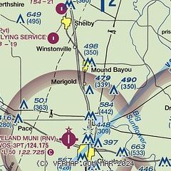
| Sectional chart |
|---|
|
| Airport distance calculator |
|---|
|
|
| Sunrise and sunset |
|---|
|
Times for 25-Apr-2026
| | Local
(UTC-5) | | Zulu
(UTC) |
|---|
| Morning civil twilight | | 05:55 | | 10:55 |
| Sunrise | | 06:21 | | 11:21 |
| Sunset | | 19:40 | | 00:40 |
| Evening civil twilight | | 20:07 | | 01:07 |
|
| Current date and time |
|---|
| Zulu (UTC) | 25-Apr-2026 06:48:46 |
|---|
| Local (UTC-5) | 25-Apr-2026 01:48:46 |
|---|
|
| METAR |
|---|
KRNV
5nm S | 250635Z AUTO 15006KT 9SM -RA FEW006 BKN075 BKN090 17/17 A2980 RMK AO2 RAB0615 P0000 T01700170 $
|
|
| TAF |
|---|
KGLH
25nm SW | 250520Z 2506/2606 17005KT 6SM TSRA BR OVC004CB FM250700 19005KT 5SM -SHRA BR VCTS OVC015CB FM250900 15005KT 6SM BR VCSH BKN007 FM251100 26005KT 6SM BR VCSH BKN004 FM251300 VRB04KT P6SM VCSH BKN007 FM251800 27005KT P6SM SCT027
|
|
| NOTAMs |
|---|
NOTAMs are issued by the DoD/FAA and will open in a separate window not controlled by AirNav.
|
|

