FAA INFORMATION EFFECTIVE 14 MAY 2026
Location
| FAA Identifier: | CDB |
| Lat/Long: | 55-12-21.3000N 162-43-34.5000W
55-12.355000N 162-43.575000W
55.2059167,-162.7262500
(estimated) |
| Elevation: | 99.5 ft. / 30.3 m (surveyed) |
| Variation: | 12E (2015) |
| Time zone: | UTC -8 (UTC -9 during Standard Time) |
| Zip code: | 99571 |
Airport Operations
| Airport use: | Open to the public |
| Activation date: | 04/1949 |
| Control tower: | no |
| ARTCC: | ANCHORAGE CENTER |
| FSS: | COLD BAY FLIGHT SERVICE STATION (on field) [907-532-2466] |
| Alternate FSS: | ENA KENAI FLIGHT SERVICE STATION [1-866-864-1737] |
| NOTAMs facility: | CDB (NOTAM-D service available) |
| Attendance: | MON - SAT 0700 - 1800 |
| Wind indicator: | yes |
| Segmented circle: | yes |
| Lights: | ATCVT MALSR RWY 15; PAPI RWY 08, 26 & 33; HIRL RWY 08/26 & 15/33 - CTAF. |
| Beacon: | white-green (lighted land airport)
PHOTOCELL OPS. |
| Fire and rescue: | ARFF index B |
| Airline operations: | CLSD TO ACR OPS MORE THAN 30 PAX SEATS EXC WRITTEN PPR - AMGR BOX 97 COLD BAY AK 99571. ARFF AVBL FOR PART 121 ETOPS ACR WITH 30 MIN NOTICE. |
Airport Communications
| CTAF: | 123.6 |
| WX ASOS: | 135.75 (907-532-2639) |
| WX AWOS-3P at KVC (17 nm E): | 118.325 (907-497-4279) |
- APCH/DEP SVC PRVDD BY ANCHORAGE ARTCC ON FREQS 118.5/278.3 (COLD BAY RCAG).
- COMMUNICATIONS PRVDD BY COLD BAY FSS ON FREQ 123.6 (CTAF).
Nearby radio navigation aids
| VOR radial/distance | | VOR name | | Freq | | Var |
|---|
| CDBr146/4.0 | | COLD BAY VORTAC | | 112.60 | | 10E |
| NDB name | | Hdg/Dist | | Freq | | Var | | ID |
|---|
| ELFEE | | 148/5.8 | | 341 | | 10E | | ELF | . .-.. ..-. |
Airport Services
| Fuel available: | 100LL JET-A |
| Parking: | tiedowns |
Runway Information
Runway 15/33
| Dimensions: | 10179 x 150 ft. / 3103 x 46 m |
| Surface: | asphalt/grooved, in good condition |
| Weight bearing capacity: | | Single wheel: | 120.0 | | Double wheel: | 246.0 | | Double tandem: | 433.0 | | Dual double tandem: | 970.0 |
|
| Runway edge lights: | high intensity |
| RUNWAY 15 | | RUNWAY 33 |
| Latitude: | 55-13.341663N | | 55-11.787380N |
| Longitude: | 162-44.273725W | | 162-43.195117W |
| Elevation: | 72.5 ft. | | 93.3 ft. |
| Traffic pattern: | left | | right |
| Runway heading: | 146 magnetic, 158 true | | 326 magnetic, 338 true |
| Declared distances: | TORA:10179 TODA:10179 ASDA:10179 LDA:10179 | | TORA:10179 TODA:10179 ASDA:10179 LDA:10179 |
| Markings: | precision, in good condition | | nonprecision, in good condition |
| Visual slope indicator: | | | 4-light PAPI on left (3.00 degrees glide path) |
| RVR equipment: | touchdown | | rollout |
| Approach lights: | MALSR: 1,400 foot medium intensity approach lighting system with runway alignment indicator lights | | |
| Touchdown point: | yes, no lights | | yes, no lights |
| Instrument approach: | ILS | | |
Runway 8/26
| Dimensions: | 4900 x 150 ft. / 1494 x 46 m |
| Surface: | asphalt/grooved, in good condition |
| Weight bearing capacity: | | Single wheel: | 120.0 | | Double wheel: | 250.0 | | Double tandem: | 431.0 | | Dual double tandem: | 966.0 |
|
| Runway edge lights: | high intensity |
| RUNWAY 8 | | RUNWAY 26 |
| Latitude: | 55-11.952648N | | 55-11.885708N |
| Longitude: | 162-43.945513W | | 162-42.543133W |
| Elevation: | 88.9 ft. | | 99.5 ft. |
| Traffic pattern: | left | | right |
| Runway heading: | 083 magnetic, 095 true | | 263 magnetic, 275 true |
| Declared distances: | TORA:4900 TODA:4900 ASDA:4900 LDA:4900 | | TORA:4900 TODA:4900 ASDA:4900 LDA:4900 |
| Markings: | nonprecision, in good condition | | nonprecision, in good condition |
| Visual slope indicator: | 4-light PAPI on left (3.50 degrees glide path)
UNUSBL BYD 5 DEGS RIGHT OF CNTRLN. | | 4-light PAPI on left (3.00 degrees glide path) |
| Touchdown point: | yes, no lights | | yes, no lights |
Airport Ownership and Management from official FAA records
| Ownership: | Publicly-owned |
| Owner: | ALASKA DOT&PF SOUTHCOAST REGION
P.O BOX 112506
JUNEAU, AK 99811-2506
Phone 907-465-1763 |
| Manager: | HAROLD KREMER
BOX 97
COLD BAY, AK 99571
Phone 907-532-5000 |
Additional Remarks
| A39-15/33 | PCR VALUE: 620/F/B/X/T |
| A39-08/26 | PCR VALUE: 620/F/B/X/T |
| - | SNOW, ICE REMOVAL & ARPT HAZ RPRTG DURG DUTY HR UNLESS PRIOR ARNGMT IN WRITING - AMGR. |
| - | PAEW ON RWYS. |
| - | ARPT SAND LRGR GRADE THAN FAA RCMDD/SEE AC150/5200-30. |
| - | WX CAMERA AVBL - HTTPS://WEATHERCAMS.FAA.GOV |
| - | DEICING & FUEL M-F 0800-1700 - 907-532-2467; AFT HR PPR & FEE - 907-532-7055. |
| - | BIRDS INVOF ARPT. |
| - | LOCKED WHEEL NA. |
| - | CUST UNAVBL. FOREIGN RFLG ARR 24-48 HR WRITTEN PPR - FAX 907-271-2684 OR 907-271-2686. |
| - | UNLGTD TWR 0.4 NM N, 0.9 NM S & 4.8 NM NW. |
Instrument Procedures
NOTE: All procedures below are presented as PDF files. If you need a reader for these files, you should download the free Adobe Reader.NOT FOR NAVIGATION. Please procure official charts for flight.
FAA instrument procedures published for use from 14 May 2026 at 0901Z to 11 June 2026 at 0900Z.
IAPs - Instrument Approach Procedures |
|---|
| HI-ILS OR LOC RWY 15 | |
download (254KB) |
| ILS OR LOC RWY 15 | |
download (370KB) |
| RNAV (GPS) RWY 15 | |
download (292KB) |
| RNAV (GPS) RWY 26 | |
download (308KB) |
| RNAV (GPS) RWY 33 | |
download (331KB) |
| LOC BC RWY 33 | |
download (387KB) |
| VOR RWY 15 | |
download (297KB) |
| HI-VOR OR TACAN RWY 15 | |
download (270KB) |
| NOTE: Special Alternate Minimums apply | |
download (154KB) |
Departure Procedures |
|---|
| CHUNA TWO | |
download (188KB) |
| WETSI TWO | |
download (155KB) |
| NOTE: Special Take-Off Minimums/Departure Procedures apply | |
download (344KB) |
Other nearby airports with instrument procedures:
PAVC - King Cove Airport (17 nm E)
PAOU - Nelson Lagoon Airport (72 nm NE)
PASD - Sand Point Airport (76 nm E)
|
|

Road maps at:
MapQuest
Bing
Google
| Aerial photo |
|---|
WARNING: Photo may not be current or correct
 Photo by Aaron Merculief
Photo taken 30-Sep-2017
looking south.
Photo by Aaron Merculief
Photo taken 30-Sep-2017
looking south.
Do you have a better or more recent aerial photo of Cold Bay Airport that you would like to share? If so, please send us your photo.
|
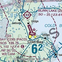
| Sectional chart |
|---|
|
 Download PDF
of official airport diagram from the FAA
| Airport distance calculator |
|---|
|
|
| Sunrise and sunset |
|---|
|
Times for 30-May-2026
| | Local
(UTC-8) | | Zulu
(UTC) |
|---|
| Morning civil twilight | | 05:27 | | 13:27 |
| Sunrise | | 06:21 | | 14:21 |
| Sunset | | 23:16 | | 07:16 |
| Evening civil twilight | | 00:10 | | 08:10 |
|
| Current date and time |
|---|
| Zulu (UTC) | 30-May-2026 09:43:28 |
|---|
| Local (UTC-8) | 30-May-2026 01:43:28 |
|---|
|
| METAR |
|---|
| PACD | 300853Z AUTO 14010KT 10SM BKN024 04/01 A2988 RMK AO2 SLP118 T00390006 400780011 51010 TSNO
|
PAVC
17nm E | 300856Z AUTO 05014KT 10SM OVC017 04/01 A2991 RMK AO2 SLP131 T00390006 400501022 51009 $
|
|
| TAF |
|---|
| PACD | 300520Z 3006/3106 16014KT P6SM FEW024 OVC110 FM300900 12008KT P6SM BKN025 FM301300 07011KT P6SM BKN035 FM301900 09011KT P6SM BKN025 FM302100 11012KT P6SM BKN060
|
|
| NOTAMs |
|---|
NOTAMs are issued by the DoD/FAA and will open in a separate window not controlled by AirNav.
|
|


