FAA INFORMATION EFFECTIVE 14 MAY 2026
Location
| FAA Identifier: | YAK |
| Lat/Long: | 59-30-11.9640N 139-39-36.9650W
59-30.199400N 139-39.616083W
59.5033233,-139.6602681
(estimated) |
| Elevation: | 39.7 ft. / 12.1 m (surveyed) |
| Variation: | 20E (2015) |
| From city: | 3 miles SE of YAKUTAT, AK |
| Time zone: | UTC -8 (UTC -9 during Standard Time) |
| Zip code: | 99689 |
Airport Operations
| Airport use: | Open to the public |
| Activation date: | 03/1949 |
| Control tower: | no |
| ARTCC: | ANCHORAGE CENTER |
| FSS: | JUNEAU FLIGHT SERVICE STATION [907-586-7380] |
| NOTAMs facility: | YAK (NOTAM-D service available) |
| Attendance: | 1530Z-0230Z |
| Wind indicator: | lighted |
| Segmented circle: | yes |
| Lights: | ACTVT MALSR RWY 11 & 29; REIL RWY 02/20; PAPI RWY 11/29 & 02/20; HIRL RWY 02/20, 11/29; TWY LIGHTS - CTAF. |
| Beacon: | white-green (lighted land airport)
Operates sunset to sunrise. |
| Fire and rescue: | ARFF index B |
| Airline operations: | ARFF INDEX B SVC AVBL DURG ACR OPS. CLSD TO ACR OPS GTR THAN 30 PAX SEATS EXC 24 HR PPR IN WRITING - AMGR PO BOX 186 YAKUTAT AK 99689. |
Airport Communications
| CTAF: | 123.6 |
| WX ASOS: | 135.75 (907-560-7615) |
- APCH/DEP SVC PRVDD BY ANCHORAGE ARTCC ON FREQS 119.0/263.1 (YAKUTAT RCAG).
- COMMUNICATIONS PRVDD BY JUNEAU FSS ON FREQ 123.6 (YAKUTAT RCO).
Nearby radio navigation aids
| VOR radial/distance | | VOR name | | Freq | | Var |
|---|
| YAK at field | | YAKUTAT VOR/DME | | 113.30 | | 20E |
| NDB name | | Hdg/Dist | | Freq | | Var | | ID |
|---|
| OCEAN CAPE | | 119/3.2 | | 385 | | 20E | | OCC | --- -.-. -.-. |
Airport Services
| Fuel available: | 100 JET-A1+ |
Runway Information
Runway 11/29
| Dimensions: | 7732 x 150 ft. / 2357 x 46 m |
| Surface: | asphalt/grooved, in good condition |
| Weight bearing capacity: | | Single wheel: | 120.0 | | Double wheel: | 203.0 | | Double tandem: | 271.0 |
|
| Runway edge lights: | high intensity |
| RUNWAY 11 | | RUNWAY 29 |
| Latitude: | 59-30.687425N | | 59-29.789665N |
| Longitude: | 139-39.881538W | | 139-38.116443W |
| Elevation: | 39.7 ft. | | 33.1 ft. |
| Traffic pattern: | left | | right |
| Runway heading: | 115 magnetic, 135 true | | 295 magnetic, 315 true |
| Markings: | precision, in fair condition | | precision, in good condition |
| Visual slope indicator: | 4-light PAPI on left (3.00 degrees glide path) | | 4-light PAPI on left (3.00 degrees glide path) |
| RVR equipment: | touchdown | | rollout |
| Approach lights: | MALSR: 1,400 foot medium intensity approach lighting system with runway alignment indicator lights | | MALSR: 1,400 foot medium intensity approach lighting system with runway alignment indicator lights |
| Touchdown point: | yes, no lights | | yes, no lights |
| Instrument approach: | ILS | | |
| Obstructions: | none | | 55 ft. trees, 1800 ft. from runway, 29:1 slope to clear |
Runway 2/20
| Dimensions: | 6475 x 150 ft. / 1974 x 46 m |
| Surface: | concrete, in good condition |
| Weight bearing capacity: | | Single wheel: | 38.0 | | Double wheel: | 107.0 | | Double tandem: | 200.0 |
|
| Runway edge lights: | high intensity
RWY LGTS RAISED 30 IN. |
| Operational restrictions: | UNMNTND & UNMNT 1 OCT - 1 MAY. RWY 02/20 NOT AVBL FOR PART 121/380 SKED AND NON-SKED OPS WITH PAX CARRYING OPS MORE THAN 30 PAX SEATS. |
| RUNWAY 2 | | RUNWAY 20 |
| Latitude: | 59-29.776610N | | 59-30.528357N |
| Longitude: | 139-41.092112W | | 139-39.614050W |
| Elevation: | 21.3 ft. | | 36.9 ft. |
| Traffic pattern: | right | | left |
| Runway heading: | 025 magnetic, 045 true | | 205 magnetic, 225 true |
| Displaced threshold: | 1388 ft. | | no |
| Declared distances: | TORA:6475 TODA:6475 ASDA:6475 LDA:5087 | | TORA:5087 TODA:5087 ASDA:6475 LDA:6475 |
| Markings: | nonprecision, in good condition | | nonprecision, in good condition |
| Visual slope indicator: | 4-light PAPI on right (3.00 degrees glide path) | | 4-light PAPI on left (3.00 degrees glide path) |
| Runway end identifier lights: | yes | | yes |
| Touchdown point: | yes, no lights | | yes, no lights |
| Obstructions: | 42 ft. brush, 1040 ft. from runway, 20:1 slope to clear | | 15 ft. brush, 500 ft. from runway, 33:1 slope to clear |
Airport Ownership and Management from official FAA records
| Ownership: | Publicly-owned |
| Owner: | ALASKA DOT&PF SOUTHCOAST REGION
6860 GLACIER HWY
JUNEAU, AK 99801-7999
Phone 907-465-1779 |
| Manager: | ROBERT LEKANOF
BOX 186
YAKUTAT, AK 99689
Phone 907-784-3293 |
Additional Remarks
| A39-11/29 | PCR VALUE: 632/F/D/X/T |
| A39-02/20 | PCR VALUE: 574/R/C/X/T |
| - | CTN: SN PILES & BERMS ON RAMP & TWY EDGES 1 OCT - 1 MAY. |
| - | PAJA NA. |
| - | TWY A1, D & APRON B CLSD TO 12500 LB & OVR. |
| - | SAND GRAD LRGR THAN FAA RCMDD/SEE AC150/5200-30. |
| - | TWY B, C, & D UNMNTND, UNMNT & LGT OTS 1 OCT - 1 MAY. |
| - | CARGO OPS OVR 100000 24 HR PPR - 907-784-3476. |
| - | WX CAMERAS AVBL AT: HTTPS://WEATHERCAMS.FAA.GOV. |
| - | PAPI RWY 02, 11, & 29; HIRL RWY 02/20; REIL RWY 02/20 OTS 1 OCT - 1 MAY. |
| - | ARPT & RWY COND RPRT, SN REMOVAL, WILDLIFE & ICE CTL DURG MAINT DUTY HR 0630-1730; AFT HR AMGR. |
| - | WX BLN LAUNCH FAC ON ARPT, SEE INSIDE BACK COVER FOR OPS DETAILS. |
| - | FUEL AVBL H24 WITH CREDIT CARD - 907-784-3311. |
| - | BIRDS & WILDLIFE ON & INVOF RWY. |
| - | TWY C & A1 CLSD DURG ACR OPS & 15 MIN AFT FOR JET BLAST. |
| - | PAEW ON RWY; RCMD VISUAL INSP BFR USE - CTC FSS FOR NOTAM. |
Instrument Procedures
NOTE: All procedures below are presented as PDF files. If you need a reader for these files, you should download the free Adobe Reader.NOT FOR NAVIGATION. Please procure official charts for flight.
FAA instrument procedures published for use from 14 May 2026 at 0901Z to 11 June 2026 at 0900Z.
STARs - Standard Terminal Arrivals |
|---|
| YAKUTAT THREE | |
download (94KB) |
IAPs - Instrument Approach Procedures |
|---|
| ILS OR LOC RWY 11 | |
download (271KB) |
| RNAV (GPS) RWY 02 | |
download (236KB) |
| RNAV (GPS) RWY 11 | |
download (276KB) |
| RNAV (GPS) RWY 29 | |
download (289KB) |
| LOC BC RWY 29 | |
download (280KB) |
| VOR/DME RWY 29 | |
download (229KB) |
| NOTE: Special Alternate Minimums apply | |
download (172KB) |
Departure Procedures |
|---|
| FAKES FOUR | |
download (139KB) |
| NOTE: Special Take-Off Minimums/Departure Procedures apply | |
download |
|
|

Road maps at:
MapQuest
Bing
Google
| Aerial photo |
|---|
WARNING: Photo may not be current or correct

Do you have a better or more recent aerial photo of Yakutat Airport that you would like to share? If so, please send us your photo.
|
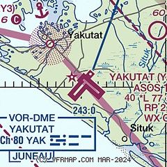
| Sectional chart |
|---|
|
| Airport distance calculator |
|---|
|
|
| Sunrise and sunset |
|---|
|
Times for 04-Jun-2026
| | Local
(UTC-8) | | Zulu
(UTC) |
|---|
| Morning civil twilight | | 02:47 | | 10:47 |
| Sunrise | | 04:09 | | 12:09 |
| Sunset | | 22:25 | | 06:25 |
| Evening civil twilight | | 23:47 | | 07:47 |
|
| Current date and time |
|---|
| Zulu (UTC) | 05-Jun-2026 06:19:53 |
|---|
| Local (UTC-8) | 04-Jun-2026 22:19:53 |
|---|
|
| METAR |
|---|
| PAYA | 050553Z AUTO 29003KT 10SM BKN011 OVC027 11/09 A2986 RMK AO2 SLP111 T01060094 10122 20106 58003 TSNO
|
|
| TAF |
|---|
| PAYA | 050521Z 0506/0606 31005KT P6SM -SHRA SCT007 BKN015 BKN035 FM051000 23005KT 5SM BR SCT007 OVC015 FM051800 17005KT P6SM VCSH SCT007 OVC015 AMD LTD TO CLD VIS AND WIND
|
|
| NOTAMs |
|---|
NOTAMs are issued by the DoD/FAA and will open in a separate window not controlled by AirNav.
|
|


