FAA INFORMATION EFFECTIVE 14 MAY 2026
Location
| FAA Identifier: | PRX |
| Lat/Long: | 33-38-11.8000N 095-27-02.7000W
33-38.196667N 095-27.045000W
33.6366111,-95.4507500
(estimated) |
| Elevation: | 547.6 ft. / 166.9 m (surveyed) |
| Variation: | 04E (2005) |
| From city: | 6 miles E of PARIS, TX |
| Time zone: | UTC -5 (UTC -6 during Standard Time) |
| Zip code: | 75462 |
Airport Operations
| Airport use: | Open to the public |
| Activation date: | 08/1943 |
| Control tower: | no |
| ARTCC: | FORT WORTH CENTER |
| FSS: | FORT WORTH FLIGHT SERVICE STATION |
| NOTAMs facility: | PRX (NOTAM-D service available) |
| Attendance: | MON-SAT 0800-1700 |
| Wind indicator: | lighted |
| Segmented circle: | yes |
| Lights: | MIRL RWY 17/35 PRESET LOW INTST DUSK-DAWN; TO INCR INTST ACTVT - CTAF. PAPI RWYS 17 & 35 OPRS CONSLY. |
| Beacon: | white-green (lighted land airport)
Operates sunset to sunrise. |
Airport Communications
| CTAF/UNICOM: | 122.975 |
| WX AWOS-3PT: | 119.675 (903-737-8784) |
- APCH/DEP SVC PRVDD BY FORT WORTH ARTCC (ZFW) ON FREQS 124.875/370.95 (BONHAM RCAG).
Nearby radio navigation aids
| VOR radial/distance | | VOR name | | Freq | | Var |
|---|
| PRXr352/5.7 | | PARIS VOR/DME | | 113.60 | | 07E |
| BYPr075/39.6 | | BONHAM VORTAC | | 114.60 | | 06E |
Airport Services
| Fuel available: | 100LL JET-A
100LL:100LL AVBL 24 HR SELF SERVE. FOR JET AFTR HRS, CALL 903-784-4648. |
| Parking: | tiedowns |
| Airframe service: | MINOR |
| Powerplant service: | MINOR |
| Bottled oxygen: | NONE |
| Bulk oxygen: | NONE |
Runway Information
Runway 17/35
| Dimensions: | 6002 x 100 ft. / 1829 x 30 m |
| Surface: | asphalt, in good condition |
| Weight bearing capacity: | |
| Runway edge lights: | medium intensity |
| RUNWAY 17 | | RUNWAY 35 |
| Latitude: | 33-38.689210N | | 33-37.699783N |
| Longitude: | 095-27.265865W | | 095-27.248850W |
| Elevation: | 541.0 ft. | | 526.3 ft. |
| Traffic pattern: | left | | left |
| Runway heading: | 175 magnetic, 179 true | | 355 magnetic, 359 true |
| Declared distances: | TORA:6002 TODA:6002 ASDA:6002 LDA:6002 | | TORA:6002 TODA:6002 ASDA:6002 LDA:6002 |
| Markings: | nonprecision, in good condition | | nonprecision, in good condition |
| Visual slope indicator: | 4-light PAPI on left (3.00 degrees glide path) | | 4-light PAPI on left (3.00 degrees glide path) |
| Touchdown point: | yes, no lights | | yes, no lights |
| Obstructions: | none
39 FT TREES, 100 FT DSTC, 390 FT L. | | 37 ft. trees, 325 ft. from runway, 260 ft. left of centerline, 3:1 slope to clear
20 FT TREES, 0-199 FT DSTC, 250 L. |
Runway 3/21
| Dimensions: | 4624 x 150 ft. / 1409 x 46 m |
| Surface: | concrete, in poor condition
RWY COND NOT MNTND. VEGETATION GROWING THROUGH CRACKS. |
| Weight bearing capacity: | |
| Runway edge markings: | MKGS FADED. |
| RUNWAY 3 | | RUNWAY 21 |
| Latitude: | 33-37.816727N | | 33-38.424280N |
| Longitude: | 095-27.180907W | | 095-26.630207W |
| Elevation: | 530.3 ft. | | 546.2 ft. |
| Traffic pattern: | left | | left |
| Runway heading: | 033 magnetic, 037 true | | 213 magnetic, 217 true |
| Declared distances: | TORA:4624 TODA:4624 ASDA:4624 LDA:4624 | | TORA:4624 TODA:4624 ASDA:4624 LDA:4624 |
| Markings: | basic, in poor condition | | basic, in poor condition |
| Touchdown point: | yes, no lights | | yes, no lights |
| Obstructions: | 28 ft. trees, 860 ft. from runway, 185 ft. left of centerline, 23:1 slope to clear | | 18 ft. trees, 407 ft. from runway, 135 ft. left and right of centerline, 11:1 slope to clear
40 FT TREES 132 FT DSTC, 245 FT L |
Runway 14/32
| Dimensions: | 4624 x 150 ft. / 1409 x 46 m |
| Surface: | concrete, in fair condition |
| Weight bearing capacity: | |
| RUNWAY 14 | | RUNWAY 32 |
| Latitude: | 33-38.573853N | | 33-37.979888N |
| Longitude: | 095-27.194007W | | 095-26.622472W |
| Elevation: | 539.5 ft. | | 547.3 ft. |
| Traffic pattern: | left | | left |
| Runway heading: | 137 magnetic, 141 true | | 317 magnetic, 321 true |
| Declared distances: | TORA:4624 TODA:4624 ASDA:4624 LDA:4624 | | TORA:4624 TODA:4624 ASDA:4624 LDA:4624 |
| Markings: | basic, in fair condition | | basic, in fair condition |
| Touchdown point: | yes, no lights | | yes, no lights |
| Obstructions: | 30 ft. trees, 455 ft. from runway, 245 ft. left of centerline, 8:1 slope to clear
10 FT BRUSH, 30 FT DSTC, 244 FT L. | | none |
Helipad H1
| Dimensions: | 40 x 40 ft. / 12 x 12 m |
| Surface: | concrete, in good condition |
| Latitude: | 33-38.071333N | | |
| Longitude: | 095-27.393667W | | |
| Elevation: | 547.6 ft. | | |
| Traffic pattern: | left | | left |
| Markings: | none, in fair condition | | |
Airport Ownership and Management from official FAA records
| Ownership: | Publicly-owned |
| Owner: | CITY OF PARIS
BOX 9037
PARIS, TX 75461
Phone 903-784-4648 |
| Manager: | THOMAS HERNDON
6780 COLLIER DR
PARIS, TX 75462
Phone 903-784-4648
THERNDON@PARISTEXAS.GOV |
Additional Remarks
| - | RWYS 03/21 & 14/32 NOT AVBL FOR ACR OPNS WITH MORE THAN 30 PSGR SEATS. |
| - | TWY LGTS FROM TRML APRON TO RWY 17/35 ON MIDFIELD TWY ONLY. |
| - | RWY 14/32 NO LINE OF SIGHT BTN RWY ENDS. |
| - | FOR CD IF UNA TO CTC ON FSS FREQ, CTC FORT WORTH ARTCC AT 817-858-7584. |
| A52-H1 | APPROACH RATIO 5:1; 28 FT TREES 178 FT WEST |
Instrument Procedures
NOTE: All procedures below are presented as PDF files. If you need a reader for these files, you should download the free Adobe Reader.NOT FOR NAVIGATION. Please procure official charts for flight.
FAA instrument procedures published for use from 14 May 2026 at 0901Z to 11 June 2026 at 0900Z.
IAPs - Instrument Approach Procedures |
|---|
| RNAV (GPS) RWY 17 | |
download (245KB) |
| RNAV (GPS) RWY 35 | |
download (264KB) |
| VOR RWY 35 | |
download (197KB) |
| NOTE: Special Alternate Minimums apply | |
download (117KB) |
| NOTE: Special Take-Off Minimums/Departure Procedures apply | |
download (299KB) |
Other nearby airports with instrument procedures:
KHHW - Stan Stamper Municipal Airport (24 nm N)
F53 - Franklin County Airport (27 nm SE)
KSLR - Sulphur Springs Municipal Airport (30 nm S)
2F7 - Commerce Municipal Airport (30 nm SW)
4O4 - Mc Curtain County Regional Airport (34 nm NE)
|
|

Road maps at:
MapQuest
Bing
Google
| Aerial photo |
|---|
WARNING: Photo may not be current or correct
 Photo by Paul Strahan
Photo taken 23-Jan-2025
looking northwest.
Photo by Paul Strahan
Photo taken 23-Jan-2025
looking northwest.
Do you have a better or more recent aerial photo of Cox Field Airport that you would like to share? If so, please send us your photo.
|
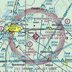
| Sectional chart |
|---|
|
| Airport distance calculator |
|---|
|
|
| Sunrise and sunset |
|---|
|
Times for 04-Jun-2026
| | Local
(UTC-5) | | Zulu
(UTC) |
|---|
| Morning civil twilight | | 05:44 | | 10:44 |
| Sunrise | | 06:13 | | 11:13 |
| Sunset | | 20:27 | | 01:27 |
| Evening civil twilight | | 20:56 | | 01:56 |
|
| Current date and time |
|---|
| Zulu (UTC) | 04-Jun-2026 09:41:50 |
|---|
| Local (UTC-5) | 04-Jun-2026 04:41:50 |
|---|
|
| METAR |
|---|
| KPRX | 040855Z AUTO 12004KT 10SM SCT030 22/21 A3006 RMK AO2 SLP174 T02220206 56003
|
|
| NOTAMs |
|---|
NOTAMs are issued by the DoD/FAA and will open in a separate window not controlled by AirNav.
|
|

