FAA INFORMATION EFFECTIVE 27 NOVEMBER 2025
Location
| FAA Identifier: | PWG |
| Lat/Long: | 31-29-05.7000N 097-18-59.5000W
31-29.095000N 097-18.991667W
31.4849167,-97.3165278
(estimated) |
| Elevation: | 591.7 ft. / 180.4 m (surveyed) |
| Variation: | 06E (2000) |
| From city: | 4 miles W of WACO, TX |
| Time zone: | UTC -6 (UTC -5 during Daylight Saving Time) |
| Zip code: | 76657 |
Airport Operations
| Airport use: | Open to the public |
| Activation date: | 01/1940 |
| Control tower: | no |
| ARTCC: | FORT WORTH CENTER |
| FSS: | FORT WORTH FLIGHT SERVICE STATION |
| NOTAMs facility: | PWG (NOTAM-D service available) |
| Attendance: | 0700-1900 |
| Wind indicator: | lighted |
| Segmented circle: | yes |
| Lights: | ACTVT REIL RWY 17 - CTAF. MIRL RWY 17/35 PRESET LOW INTST; TO INCR INTST ACTVT - CTAF. |
| Beacon: | white-green (lighted land airport)
Operates sunset to sunrise. |
Airport Communications
| CTAF/UNICOM: | 123.05 |
| WX AWOS-3PT: | 135.525 (254-848-4581) |
| WACO APPROACH: | 127.65 [0600-0000] |
| WACO DEPARTURE: | 126.125 [0600-0000] |
| ASR: | 132.525 |
| WX ASOS at ACT (9 nm NE): | PHONE 254-218-3267 |
| WX AWOS-3PT at CNW (15 nm NE): | 134.225 (254-867-3880) |
- APCH/DEP CTL SVC PRVDD BY FORT WORTH ARTCC (ZFW) ON FREQS 133.3/269.5 (WACO RCAG) WHEN WACO APCH CTL (ACT) CLSD.
Nearby radio navigation aids
| VOR radial/distance | | VOR name | | Freq | | Var |
|---|
| ACTr184/10.9 | | WACO VORTAC | | 115.30 | | 09E |
| GRKr036/37.2 | | GRAY VOR/DME | | 111.80 | | 07E |
| NDB name | | Hdg/Dist | | Freq | | Var | | ID |
|---|
| ROBINSON | | 262/12.7 | | 400 | | 03E | | ROB | .-. --- -... |
Airport Services
| Fuel available: | 100LL JET-A1+
100LL:AFT HRS FUEL CALL 254-379-8204. CALL-IN FEE. MILITARY FUEL CONTRACT. |
| Parking: | hangars and tiedowns |
| Airframe service: | MAJOR |
| Powerplant service: | MAJOR |
| Bottled oxygen: | HIGH/LOW |
| Bulk oxygen: | HIGH/LOW |
Runway Information
Runway 17/35
| Dimensions: | 5501 x 75 ft. / 1677 x 23 m |
| Surface: | asphalt, in good condition |
| Weight bearing capacity: | | Single wheel: | 30.0 | | Double wheel: | 50.0 |
|
| Runway edge lights: | medium intensity |
| RUNWAY 17 | | RUNWAY 35 |
| Latitude: | 31-29.627567N | | 31-28.720350N |
| Longitude: | 097-19.100483W | | 097-19.082000W |
| Elevation: | 590.5 ft. | | 566.0 ft. |
| Traffic pattern: | left | | left |
| Runway heading: | 173 magnetic, 179 true | | 353 magnetic, 359 true |
| Markings: | nonprecision, in good condition | | nonprecision, in good condition |
| Visual slope indicator: | 4-light PAPI on left (3.00 degrees glide path) | | 4-light PAPI on left (3.00 degrees glide path) |
| Runway end identifier lights: | yes | | |
| Touchdown point: | yes, no lights | | yes, no lights |
| Obstructions: | 32 ft. trees, 1100 ft. from runway, 235 ft. left and right of centerline, 28:1 slope to clear | | 42 ft. trees, 1200 ft. from runway, 680 ft. left and right of centerline, 23:1 slope to clear |
Runway 4/22
| Dimensions: | 3484 x 55 ft. / 1062 x 17 m |
| Surface: | asphalt, in fair condition |
| Weight bearing capacity: | |
| RUNWAY 4 | | RUNWAY 22 |
| Latitude: | 31-28.763567N | | 31-29.177467N |
| Longitude: | 097-19.066500W | | 097-18.601283W |
| Elevation: | 567.6 ft. | | 568.0 ft. |
| Traffic pattern: | left | | left |
| Runway heading: | 038 magnetic, 044 true | | 218 magnetic, 224 true |
| Markings: | basic, in good condition | | basic, in good condition |
| Touchdown point: | yes, no lights | | yes, no lights |
| Obstructions: | 80 ft. trees, 2650 ft. from runway, 375 ft. left and right of centerline, 30:1 slope to clear | | none |
Airport Ownership and Management from official FAA records
| Ownership: | Publicly-owned |
| Owner: | CITY OF MCGREGOR
302 S MADISON ST, P O BOX 192
MC GREGOR, TX 76657
Phone 254-840-2806 |
| Manager: | BARRY LIGHTFOOT
PO BOX 192
MC GREGOR, TX 76657
Phone 254-848-5477
OR 254-848-2345. (FBO) 254-840-2855 (POLICE) |
Additional Remarks
| - | CALM WIND LESS THAN 5 KNOTS USE RWY 17. |
| - | 2550 FT MSL TWRS, 8 MILES SOUTH RWY 35 END. |
| - | FOR CD IF UNA VIA GCO CTC FORT WORTH ARTCC AT 817-858-7584. |
Instrument Procedures
NOTE: All procedures below are presented as PDF files. If you need a reader for these files, you should download the free Adobe Reader.NOT FOR NAVIGATION. Please procure official charts for flight.
FAA instrument procedures published for use from 27 November 2025 at 0901Z to 25 December 2025 at 0900Z.
IAPs - Instrument Approach Procedures |
|---|
| RNAV (GPS) RWY 17 | |
download (232KB) |
| RNAV (GPS) RWY 35 | |
download (254KB) |
| VOR RWY 17 | |
download (191KB) |
| Radar Approach Procedures available | |
download (164KB) |
| NOTE: Special Alternate Minimums apply | |
download (117KB) |
| NOTE: Special Take-Off Minimums/Departure Procedures apply | |
download (294KB) |
Other nearby airports with instrument procedures:
KACT - Waco Regional Airport (9 nm NE)
KCNW - TSTC Waco Airport (15 nm NE)
KTPL - Draughon-Miller Central Texas Regional Airport (21 nm S)
T15 - Marlin Airport (25 nm E)
KHLR - Yoakum-Defrenn Army Heliport (29 nm SW)
|
|

Road maps at:
MapQuest
Bing
Google
| Aerial photo |
|---|
WARNING: Photo may not be current or correct
 Photo by J. Gary Hendricks
Photo taken 04-May-2020
Photo by J. Gary Hendricks
Photo taken 04-May-2020
Do you have a better or more recent aerial photo of Mc Gregor Executive Airport that you would like to share? If so, please send us your photo.
|
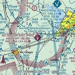
| Sectional chart |
|---|
|
| Airport distance calculator |
|---|
|
|
| Sunrise and sunset |
|---|
|
Times for 15-Dec-2025
| | Local
(UTC-6) | | Zulu
(UTC) |
|---|
| Morning civil twilight | | 06:55 | | 12:55 |
| Sunrise | | 07:22 | | 13:22 |
| Sunset | | 17:27 | | 23:27 |
| Evening civil twilight | | 17:54 | | 23:54 |
|
| Current date and time |
|---|
| Zulu (UTC) | 16-Dec-2025 00:57:44 |
|---|
| Local (UTC-6) | 15-Dec-2025 18:57:44 |
|---|
|
| METAR |
|---|
| KPWG | 152356Z AUTO 16005KT 10SM CLR 08/M05 A3028 RMK AO2 SLP257 T00831050 10117 20072 56013
|
KACT
9nm NE | 152051Z 15006KT 10SM CLR 11/M06 A3032
|
KCNW
16nm NE | 152355Z 17005KT 10SM CLR 09/M08 A3028
|
|
| TAF |
|---|
KACT
9nm NE | 152048Z 1521/1618 17006KT P6SM BKN250 FM161500 18014KT P6SM BKN250
|
|
| NOTAMs |
|---|
NOTAMs are issued by the DoD/FAA and will open in a separate window not controlled by AirNav.
|
|


