FAA INFORMATION EFFECTIVE 14 MAY 2026
Location
| FAA Identifier: | 0G7 |
| Lat/Long: | 42-53-00.8000N 076-46-52.2000W
42-53.013333N 076-46.870000W
42.8835556,-76.7811667
(estimated) |
| Elevation: | 491.8 ft. / 149.9 m (surveyed) |
| Variation: | 12W (1985) |
| From city: | 2 miles SE of SENECA FALLS, NY |
| Time zone: | UTC -4 (UTC -5 during Standard Time) |
| Zip code: | 13148 |
Airport Operations
| Airport use: | Open to the public |
| Activation date: | 06/1943 |
| Control tower: | no |
| ARTCC: | BOSTON CENTER |
| FSS: | BUFFALO FLIGHT SERVICE STATION |
| NOTAMs facility: | BUF (NOTAM-D service available) |
| Attendance: | 0800-1600 |
| Wind indicator: | lighted |
| Segmented circle: | yes |
| Lights: | ACTVT REIL RWY 01 & 19; MIRL RWY 01/19 - CTAF. |
| Beacon: | white-green (lighted land airport)
Operates sunset to sunrise. |
| Landing fee: | yes, LANDING FEE FOR JETS AND TURBO PROPS. |
Airport Communications
| CTAF/UNICOM: | 122.8 |
| WX AWOS-3: | 120.0 (315-568-5362) |
| ELMIRA APPROACH: | 124.3 ;SW-SE 119.55 ;W-NW 126.125 |
| ELMIRA DEPARTURE: | 126.125 |
| IC: | 124.3 ;SW-SE 119.55 ;W-NW |
| WX AWOS-3P at 6B9 (15 nm E): | 120.125 (315-685-5790) |
| WX ASOS at PEO (19 nm SW): | 121.175 (315-536-4102) |
- APCH SVC PRVDD BY NEW YORK ARTCC ON FREQS 133.35/372.0 (SAYRE RCAG) WHEN ELMIRA APCH CTL CLSD.
Nearby radio navigation aids
| VOR radial/distance | | VOR name | | Freq | | Var |
|---|
| SYRr248/30.3 | | SYRACUSE VORTAC | | 117.00 | | 11W |
| NDB name | | Hdg/Dist | | Freq | | Var | | ID |
|---|
| ALPINE | | 011/38.7 | | 245 | | 12W | | ALP | .- .-.. .--. |
Airport Services
| Fuel available: | 100LL JET-A |
| Parking: | hangars and tiedowns |
| Airframe service: | MAJOR |
| Powerplant service: | MAJOR |
| Bottled oxygen: | NONE |
| Bulk oxygen: | NONE |
Runway Information
Runway 1/19
| Dimensions: | 4592 x 75 ft. / 1400 x 23 m |
| Surface: | asphalt, in good condition |
| Weight bearing capacity: | | Single wheel: | 12.5 | | Double wheel: | 30.0 |
|
| Runway edge lights: | medium intensity |
| RUNWAY 1 | | RUNWAY 19 |
| Latitude: | 42-52.611355N | | 42-53.364773N |
| Longitude: | 076-46.888417W | | 076-46.970995W |
| Elevation: | 490.7 ft. | | 481.6 ft. |
| Traffic pattern: | left | | left |
| Runway heading: | 007 magnetic, 355 true | | 187 magnetic, 175 true |
| Displaced threshold: | 392 ft. | | no |
| Declared distances: | TORA:4592 TODA:4592 ASDA:4592 LDA:4199 | | TORA:4592 TODA:4592 ASDA:4592 LDA:4292 |
| Markings: | nonprecision, in fair condition | | basic, in fair condition |
| Visual slope indicator: | 2-light PAPI on left (3.00 degrees glide path) | | 2-light PAPI on left (3.00 degrees glide path) |
| Runway end identifier lights: | yes | | yes |
| Touchdown point: | yes, no lights | | yes, no lights |
| Obstructions: | 35 ft. trees, 404 ft. from runway, 243 ft. left of centerline, 5:1 slope to clear
RWY 01 HAS 15 FT ROAD 90 FT FM RWY PERPENDICULAR TO RWY; 2 FT BERM, PARL TO RWY, 99 FT RIGHT. | | 4 ft. crops, 201 ft. from runway, 112 ft. left of centerline
4 FT CROPS, AT THLD, 111 FT LEFT. |
Runway 11/29
| Dimensions: | 1850 x 60 ft. / 564 x 18 m |
| Surface: | turf, in good condition |
| RUNWAY 11 | | RUNWAY 29 |
| Latitude: | 42-53.092798N | | 42-53.059662N |
| Longitude: | 076-46.927987W | | 076-46.516285W |
| Elevation: | 488.9 ft. | | 465.7 ft. |
| Traffic pattern: | left | | left |
| Runway heading: | 108 magnetic, 096 true | | 288 magnetic, 276 true |
| Runway end identifier lights: | no | | no |
| Touchdown point: | yes, no lights | | yes, no lights |
| Obstructions: | 33 ft. trees, 457 ft. from runway, 81 ft. left of centerline, 13:1 slope to clear
RWY 29 HAS 17 FT ROAD 30 FT FM RWY THLD, PERPENDICULAR TO RWY. | | 53 ft. trees, 74 ft. from runway, 82 ft. right of centerline, 1:1 slope to clear |
Airport Ownership and Management from official FAA records
| Ownership: | Publicly-owned |
| Owner: | SENECA COUNTY
1 DEPRONIO DR
WATERLOO, NY 13165
Phone 315-539-5655 |
| Manager: | DAVID HAIMES
2727 MARTIN RD
SENECA FALLS, NY 13148
Phone 315-539-1640 |
Additional Remarks
| - | MEDIVAC HEL FLT SERVICE ON ARPT; MONITOR CTAF FOR OPS. |
| - | FOR CD CTC SYRACUSE APCH AT 315-455-6218. |
Instrument Procedures
NOTE: All procedures below are presented as PDF files. If you need a reader for these files, you should download the free Adobe Reader.NOT FOR NAVIGATION. Please procure official charts for flight.
FAA instrument procedures published for use from 14 May 2026 at 0901Z to 11 June 2026 at 0900Z.
IAPs - Instrument Approach Procedures |
|---|
| RNAV (GPS) RWY 01 | |
download (261KB) |
| RNAV (GPS) RWY 19 | |
download (239KB) |
| NOTE: Special Take-Off Minimums/Departure Procedures apply | |
download |
Other nearby airports with instrument procedures:
6B9 - Skaneateles Aero Drome (15 nm E)
B16 - Whitfords Airport (16 nm NE)
KPEO - Penn Yan/Yates County Airport (19 nm SW)
KIUA - Canandaigua Airport (24 nm W)
KSDC - Williamson/Sodus Airport (26 nm NW)
|
|

Road maps at:
MapQuest
Bing
Google
| Aerial photo |
|---|
WARNING: Photo may not be current or correct

Do you have a better or more recent aerial photo of Finger Lakes Regional Airport that you would like to share? If so, please send us your photo.
|
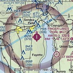
| Sectional chart |
|---|
|
| Airport distance calculator |
|---|
|
|
| Sunrise and sunset |
|---|
|
Times for 30-May-2026
| | Local
(UTC-4) | | Zulu
(UTC) |
|---|
| Morning civil twilight | | 04:59 | | 08:59 |
| Sunrise | | 05:33 | | 09:33 |
| Sunset | | 20:36 | | 00:36 |
| Evening civil twilight | | 21:10 | | 01:10 |
|
| Current date and time |
|---|
| Zulu (UTC) | 30-May-2026 13:45:03 |
|---|
| Local (UTC-4) | 30-May-2026 09:45:03 |
|---|
|
| METAR |
|---|
K6B9
15nm E | 301335Z AUTO 36008G16KT 320V020 10SM SCT020 BKN026 OVC032 11/07 A3004 RMK AO2
|
KPEO
18nm SW | 301336Z AUTO 34012G20KT 10SM BKN022 OVC034 11/06 A3008 RMK AO2 T01060056
|
KIUA
24nm W | 301335Z AUTO 02013G17KT 10SM OVC026 12/07 A3011 RMK AO2 T01150066 PWINO
|
KSDC
26nm NW | 301335Z AUTO 01007KT 330V070 10SM BKN030 OVC036 10/05 A3012 RMK AO2
|
KITH
29nm SE | 301256Z 34009G20KT 10SM OVC018 09/07 A3001 RMK AO2 RAB48E52 PRESRR SLP163 T00940067 PNO
|
|
| TAF |
|---|
KITH
29nm SE | 301120Z 3012/3112 32010G20KT P6SM BKN025 FM301500 34012G24KT P6SM FEW035 FM310200 VRB03KT P6SM SKC
|
KSYR
33nm NE | 301120Z 3012/3112 32010G20KT P6SM BKN029 FM301330 36013G23KT P6SM SCT035 FM310200 VRB03KT P6SM SKC
|
|
| NOTAMs |
|---|
NOTAMs are issued by the DoD/FAA and will open in a separate window not controlled by AirNav.
|
|

