FAA INFORMATION EFFECTIVE 09 JULY 2026
Location
| FAA Identifier: | 0M4 |
| Lat/Long: | 36-00-34.3500N 088-07-29.0200W
36-00.572500N 088-07.483667W
36.0095417,-88.1247278
(estimated) |
| Elevation: | 468 ft. / 142.6 m (surveyed) |
| Variation: | 02W (2010) |
| From city: | 3 miles S of CAMDEN, TN |
| Time zone: | UTC -5 (UTC -6 during Standard Time) |
| Zip code: | 38320 |
Airport Operations
| Airport use: | Open to the public |
| Activation date: | 08/1964 |
| Control tower: | no |
| ARTCC: | MEMPHIS CENTER |
| FSS: | JACKSON FLIGHT SERVICE STATION |
| NOTAMs facility: | MKL (NOTAM-D service available) |
| Attendance: | MON-SAT 0800-1600
UNATNDD HOL.
AFT HR - 731-441-2196. |
| Wind indicator: | lighted |
| Segmented circle: | yes |
| Lights: | ACTVT REIL RWY 04 & 22 - CTAF. |
| Beacon: | white-green (lighted land airport)
Operates sunset to sunrise. |
Airport Communications
| CTAF/UNICOM: | 122.8 |
| WX AWOS-3 at HZD (17 nm W): | 133.275 (731-352-2854) |
- APCH/DEP SVC PRVDD BY MEMPHIS ARTCC ON FREQS 125.85/379.25 (CENTERVILLE RCAG).
Airport Services
| Fuel available: | 100LL JET-A |
| Parking: | tiedowns |
Runway Information
Runway 4/22
| Dimensions: | 5001 x 75 ft. / 1524 x 23 m |
| Surface: | asphalt, in good condition |
| Weight bearing capacity: | | PCN 15 /F/D/X/T | | Single wheel: | 39.5 | | Double wheel: | 52.0 |
|
| Runway edge lights: | medium intensity |
| RUNWAY 4 | | RUNWAY 22 |
| Latitude: | 36-00.234000N | | 36-00.911000N |
| Longitude: | 088-07.773167W | | 088-07.194167W |
| Elevation: | 468.0 ft. | | 464.9 ft. |
| Traffic pattern: | left | | left |
| Runway heading: | 037 magnetic, 035 true | | 217 magnetic, 215 true |
| Markings: | nonprecision, in good condition | | nonprecision, in good condition |
| Visual slope indicator: | 2-light PAPI on left (3.50 degrees glide path) | | 2-light PAPI on left (3.35 degrees glide path) |
| Runway end identifier lights: | yes | | yes |
| Touchdown point: | yes, no lights | | yes, no lights |
| Obstructions: | 68 ft. trees, 1558 ft. from runway, 295 ft. left of centerline, 19:1 slope to clear | | 73 ft. trees, 1655 ft. from runway, 193 ft. right of centerline, 19:1 slope to clear |
Airport Ownership and Management from official FAA records
| Ownership: | Publicly-owned |
| Owner: | BENTON COUNTY
1 COURT SQUARE, ROOM 102
CAMDEN, TN 38320
Phone 731-584-6011 |
| Manager: | RITA HASLAM
275 AIRPORT DR
CAMDEN, TN 38320
Phone 731-584-5343 |
Additional Remarks
| - | FOR CD CTC MEMPHIS ARTCC AT 901-368-8453/8449. |
Instrument Procedures
NOTE: All procedures below are presented as PDF files. If you need a reader for these files, you should download the free Adobe Reader.NOT FOR NAVIGATION. Please procure official charts for flight.
FAA instrument procedures published for use from 09 July 2026 at 0901Z to 06 August 2026 at 0900Z.
IAPs - Instrument Approach Procedures |
|---|
| RNAV (GPS) RWY 04 **CHANGED** | |
download (204KB) |
| RNAV (GPS) RWY 22 **CHANGED** | |
download (215KB) |
| NOTE: Special Take-Off Minimums/Departure Procedures apply | |
download (400KB) |
Other nearby airports with instrument procedures:
KHZD - Sgt. Lee Russell Carroll County Airport (17 nm W)
0M5 - Humphreys County Airport (20 nm E)
KPVE - Beech River Regional Airport (21 nm S)
KPHT - Henry County Airport (23 nm NW)
M02 - Dickson Municipal Airport (34 nm E)
|
|

Road maps at:
MapQuest
Bing
Google
| Aerial photo |
|---|
WARNING: Photo may not be current or correct
 Taken early May 2010
Do you have a better or more recent aerial photo of Benton County Airport that you would like to share? If so, please send us your photo.
|
| Sectional chart |
|---|
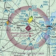
|
| Airport distance calculator |
|---|
|
|
| Sunrise and sunset |
|---|
|
Times for 10-Jul-2026
| | Local
(UTC-5) | | Zulu
(UTC) |
|---|
| Morning civil twilight | | 05:15 | | 10:15 |
| Sunrise | | 05:45 | | 10:45 |
| Sunset | | 20:11 | | 01:11 |
| Evening civil twilight | | 20:40 | | 01:40 |
|
| Current date and time |
|---|
| Zulu (UTC) | 11-Jul-2026 02:40:39 |
|---|
| Local (UTC-5) | 10-Jul-2026 21:40:39 |
|---|
|
| METAR |
|---|
KHZD
17nm W | 110210Z AUTO 20005KT 10SM SCT120 26/24 A2996 RMK A01
|
KPVE
21nm S | 110155Z AUTO 00000KT 10SM CLR 24/22 A2999 RMK A01
|
KPHT
23nm NW | 110155Z AUTO 00000KT 10SM SCT120 26/26 A2997 RMK A01
|
|
| NOTAMs |
|---|
NOTAMs are issued by the DoD/FAA and will open in a separate window not controlled by AirNav.
|
|

