FAA INFORMATION EFFECTIVE 14 MAY 2026
Location
| FAA Identifier: | HZD |
| Lat/Long: | 36-05-21.4705N 088-27-47.8756W
36-05.357842N 088-27.797927W
36.0892974,-88.4632988
(estimated) |
| Elevation: | 496.6 ft. / 151.4 m (surveyed) |
| Variation: | 02W (2010) |
| From city: | 4 miles NW of HUNTINGDON, TN |
| Time zone: | UTC -5 (UTC -6 during Standard Time) |
| Zip code: | 38201 |
Airport Operations
| Airport use: | Open to the public |
| Activation date: | 06/1987 |
| Control tower: | no |
| ARTCC: | MEMPHIS CENTER |
| FSS: | JACKSON FLIGHT SERVICE STATION |
| NOTAMs facility: | MKL (NOTAM-D service available) |
| Attendance: | MON-SAT 0800-1700, ALL SUN 1300-1700
AFT HR - 731-641-0123. |
| Wind indicator: | lighted |
| Segmented circle: | yes |
| Lights: | ACTVT REIL RWY 01 & 19; PAPI RWY 01 & 19; MIRL RWY 01/19 - CTAF. MIRL RWY 01/19 PRESET MED INTST; INCR INTST - CTAF. |
| Beacon: | white-green (lighted land airport)
Operates sunset to sunrise. |
Airport Communications
| CTAF/UNICOM: | 122.8 |
| WX AWOS-3: | 133.275 (731-352-2854) |
| WX AWOS-3 at PHT (15 nm N): | 118.825 (731-644-0451) |
- APCH/DEP SVC PRVDD BY MEMPHIS ARTCC ON FREQS 134.65/316.15 (MCKELLAR RCAG).
Nearby radio navigation aids
| VOR radial/distance | | VOR name | | Freq | | Var |
|---|
| MKLr038/36.4 | | MC KELLAR VOR/DME | | 114.85 | | 01W |
Airport Services
| Fuel available: | 100LL JET-A+ |
| Parking: | hangars and tiedowns |
| Airframe service: | MAJOR |
| Powerplant service: | MAJOR |
| Bottled oxygen: | NONE |
| Bulk oxygen: | NONE |
Runway Information
Runway 1/19
| Dimensions: | 5507 x 100 ft. / 1679 x 30 m |
| Surface: | asphalt, in good condition |
| Weight bearing capacity: | | PCN 6 /F/D/X/T | | Single wheel: | 16.5 |
|
| Runway edge lights: | medium intensity |
| RUNWAY 1 | | RUNWAY 19 |
| Latitude: | 36-04.914290N | | 36-05.801393N |
| Longitude: | 088-27.916293W | | 088-27.679558W |
| Elevation: | 495.3 ft. | | 496.6 ft. |
| Traffic pattern: | left | | left |
| Runway heading: | 014 magnetic, 012 true | | 194 magnetic, 192 true |
| Markings: | nonprecision, in good condition | | nonprecision, in fair condition |
| Visual slope indicator: | 4-light PAPI on left (3.00 degrees glide path)
PAPI UNUSBL BYD 9 DEGS RIGHT OF CNTRLN. | | 4-light PAPI on left (4.00 degrees glide path)
PAPI UNUSBL BYD 9 DEGS LEFT AND 8 DEGS RIGHT OF CNTRLN. |
| Runway end identifier lights: | yes | | yes |
| Touchdown point: | yes, no lights | | yes, no lights |
| Obstructions: | 73 ft. tree, 2166 ft. from runway, 468 ft. right of centerline, 26:1 slope to clear | | 74 ft. tree, 1317 ft. from runway, 322 ft. left of centerline, 15:1 slope to clear |
Helipad H1
| Dimensions: | 50 x 50 ft. / 15 x 15 m |
| Surface: | concrete/dirt |
| Latitude: | 36-05.066667N | | |
| Longitude: | 088-27.971500W | | |
| Elevation: | 497.0 ft. | | |
| Traffic pattern: | left | | left |
Airport Ownership and Management from official FAA records
| Ownership: | Publicly-owned |
| Owner: | CARROLL COUNTY
625 HIGH STREET, SUITE 101
HUNTINGDON, TN 38344
Phone 731-986-1936 |
| Manager: | RICHARD DOMINAS
535 AIRPORT LANE
MCKENZIE, TN 38201
Phone 731-352-7278 |
Additional Remarks
| - | FOR CD CTC MEMPHIS ARTCC AT 901-368-8453/8449. |
Instrument Procedures
NOTE: All procedures below are presented as PDF files. If you need a reader for these files, you should download the free Adobe Reader.NOT FOR NAVIGATION. Please procure official charts for flight.
FAA instrument procedures published for use from 14 May 2026 at 0901Z to 11 June 2026 at 0900Z.
IAPs - Instrument Approach Procedures |
|---|
| RNAV (GPS) RWY 01 | |
download (251KB) |
| RNAV (GPS) RWY 19 | |
download (248KB) |
| NOTE: Special Take-Off Minimums/Departure Procedures apply | |
download (402KB) |
Other nearby airports with instrument procedures:
KPHT - Henry County Airport (15 nm N)
0M4 - Benton County Airport (17 nm E)
KTGC - Gibson County Airport (21 nm SW)
M53 - Humboldt Municipal Airport (26 nm SW)
KPVE - Beech River Regional Airport (29 nm SE)
|
|

Road maps at:
MapQuest
Bing
Google
| Aerial photo |
|---|
WARNING: Photo may not be current or correct
 Photo courtesy of AirNav, LLC
Photo taken 15-Sep-2013
Photo courtesy of AirNav, LLC
Photo taken 15-Sep-2013
Do you have a better or more recent aerial photo of Sgt. Lee Russell Carroll County Airport that you would like to share? If so, please send us your photo.
|
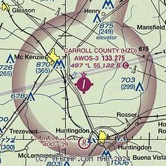
| Sectional chart |
|---|
|
| Airport distance calculator |
|---|
|
|
| Sunrise and sunset |
|---|
|
Times for 01-Jun-2026
| | Local
(UTC-5) | | Zulu
(UTC) |
|---|
| Morning civil twilight | | 05:09 | | 10:09 |
| Sunrise | | 05:39 | | 10:39 |
| Sunset | | 20:04 | | 01:04 |
| Evening civil twilight | | 20:34 | | 01:34 |
|
| Current date and time |
|---|
| Zulu (UTC) | 01-Jun-2026 09:38:56 |
|---|
| Local (UTC-5) | 01-Jun-2026 04:38:56 |
|---|
|
| METAR |
|---|
| KHZD | 010910Z AUTO 00000KT 6SM BR FEW100 19/19 A2994 RMK A01
|
KPHT
15nm N | 010915Z AUTO 00000KT 6SM BR 19/19 A2994 RMK A01
|
|
| TAF |
|---|
KMKL
37nm SW | 010520Z 0106/0206 00000KT P6SM SCT250 TEMPO 0108/0112 3SM BR FEW003 FM011300 VRB02KT P6SM VCTS SCT025CB BKN200 PROB30 0115/0117 34015G30KT 1SM +TSRA BKN025CB FM011800 27005KT P6SM SCT045 PROB30 0200/0202 34010G20KT 4SM -TSRA BKN035CB FM020300 02005KT P6SM FEW100
|
|
| NOTAMs |
|---|
NOTAMs are issued by the DoD/FAA and will open in a separate window not controlled by AirNav.
|
|

