FAA INFORMATION EFFECTIVE 11 JUNE 2026
Location
| FAA Identifier: | 14G |
| Lat/Long: | 41-19-59.1000N 083-09-40.3000W
41-19.985000N 083-09.671667W
41.3330833,-83.1611944
(estimated) |
| Elevation: | 663.2 ft. / 202.1 m (surveyed) |
| Variation: | 05W (1985) |
| From city: | 2 miles SW of FREMONT, OH |
| Time zone: | UTC -4 (UTC -5 during Standard Time) |
| Zip code: | 43420 |
Airport Operations
| Airport use: | Open to the public |
| Activation date: | 06/1962 |
| Control tower: | no |
| ARTCC: | CLEVELAND CENTER |
| FSS: | CLEVELAND FLIGHT SERVICE STATION |
| NOTAMs facility: | CLE (NOTAM-D service available) |
| Attendance: | MON-SAT 0900-1600, ALL SUN 1200-1600 |
| Wind indicator: | yes, WINDCONE FADED. |
| Segmented circle: | no |
| Lights: | ACTVT LIRL RWY 09/27 - 5 SLOW CLICKS CTAF. |
Airport Communications
| CTAF/UNICOM: | 122.8 |
| TOLEDO APPROACH: | 126.1 |
| TOLEDO DEPARTURE: | 126.1 |
| WX AWOS-3P at S24 (6 nm E): | 119.575 (419-547-6932) |
| WX AWOS-3 at FZI (13 nm SW): | 124.625 (419-436-0053) |
| WX AWOS-3PT at 16G (15 nm S): | 127.175 (419-443-1043) |
| WX AWOS-3 at PCW (17 nm NE): | 118.775 (419-734-9955) |
Nearby radio navigation aids
| VOR radial/distance | | VOR name | | Freq | | Var |
|---|
| FBCr052/35.2 | | FLAG CITY VORTAC | | 108.20 | | 02W |
| NDB name | | Hdg/Dist | | Freq | | Var | | ID |
|---|
| TIFFIN | | 015/14.5 | | 269 | | 05W | | TII | - .. .. |
Airport Services
| Fuel available: | 100LL
100LL:AFT HRS FUEL 419-307-3111. |
| Parking: | hangars and tiedowns |
| Airframe service: | MAJOR |
| Powerplant service: | MAJOR |
Runway Information
Runway 9/27
| Dimensions: | 4137 x 60 ft. / 1261 x 18 m |
| Surface: | asphalt, in poor condition
OUTER 15 FT EACH SIDE WDSPR CRACKING, LOOSE STONES, & VEGETATION GROWTH; CNTR 30 FT FAIR COND. |
| Weight bearing capacity: | |
| Runway edge lights: | low intensity |
| Runway edge markings: | RWY NR FADED.
NSTD DUE TO WHITE LN MARKS RWY END. |
| RUNWAY 9 | | RUNWAY 27 |
| Latitude: | 41-20.053565N | | 41-20.050283N |
| Longitude: | 083-10.044718W | | 083-09.140987W |
| Elevation: | 652.2 ft. | | 660.3 ft. |
| Traffic pattern: | left | | left |
| Runway heading: | 095 magnetic, 090 true | | 275 magnetic, 270 true |
| Displaced threshold: | 126 ft. | | no |
| Markings: | NSTD, in fair condition | | NSTD, in poor condition |
| Runway end identifier lights: | no | | no |
| Touchdown point: | yes, no lights | | yes, no lights |
| Obstructions: | 16 ft. road, 223 ft. from runway, 125 ft. left and right of centerline, 1:1 slope to clear
16 FT ROAD, 120 FT DIST, 250 FT L/R. | | 39 ft. trees, 293 ft. from runway, 73 ft. right of centerline, 2:1 slope to clear
+50 FT TREES, 0 FT DIST, 100 FT L; -15 FT DROP OFF EAST END. EAST 330 FT UNUSBL. |
Runway 18/36
| Dimensions: | 2238 x 130 ft. / 682 x 40 m
MOWED 58 FT WIDE. EAST EDGE OF RWY OBSTD BY +60 FT TREES, 50 FT FM CNTRLN, ENTR LEN OF RWY. |
| Surface: | turf, in fair condition |
| RUNWAY 18 | | RUNWAY 36 |
| Latitude: | 41-20.046347N | | 41-19.677858N |
| Longitude: | 083-09.815092W | | 083-09.823760W |
| Elevation: | 654.2 ft. | | 656.9 ft. |
| Traffic pattern: | left | | left |
| Runway heading: | 186 magnetic, 181 true | | 006 magnetic, 001 true |
| Markings: | none | | none |
| Obstructions: | 90 ft. trees, 262 ft. from runway, 94 ft. left of centerline, 2:1 slope to clear
+60 TREES, 0 FT DIST, 125 FT L/R. CTLG OBSTN EXCEEDS A 45 DEG SLP. | | 60 ft. tree, 125 ft. both sides of centerline |
Airport Ownership and Management from official FAA records
| Ownership: | Privately-owned |
| Owner: | FREMONT AIRPORT LLC
365 S STATE ROUTE 53
FREMONT, OH 43420-9668
Phone 419-332-8037 |
| Manager: | REX DAMSCHRODER
365 S STATE ROUTE 53
FREMONT, OH 43420-9668
Phone 419-307-3111
ADNL CTC MOLLY JOHNSON 419-443-5108. |
Additional Remarks
| - | RWY 27 ONLY 3390 FT LGTD. 3900 FT PAVEMENT AVBL DALGT HRS. |
| - | RWY 27: WHITE LN MARKS RWY END, 330 FT OF PAVEMENT EAST OF LINE FAILED & UNSUITABLE FOR ACFT DUE TO WDSPR SVR CRACKING, DSTNS OVR 3 IN, & WDSPR VEGETATION GROWTH. |
| - | DEER & BIRDS ON & INVOF ARPT. |
| - | FOR CD CTC TOLEDO APCH AT 419-865-1495. |
| - | PUBLD RWY DIMENSIONS DO NOT MATCH PAVEMENT MRKGS. |
Instrument Procedures
NOTE: All procedures below are presented as PDF files. If you need a reader for these files, you should download the free Adobe Reader.NOT FOR NAVIGATION. Please procure official charts for flight.
FAA instrument procedures published for use from 11 June 2026 at 0901Z to 09 July 2026 at 0900z.
IAPs - Instrument Approach Procedures |
|---|
| RNAV (GPS) RWY 09 | |
download (182KB) |
| NOTE: Special Take-Off Minimums/Departure Procedures apply | |
download (164KB) |
Other nearby airports with instrument procedures:
S24 - Sandusky County Regional Airport (6 nm E)
KFZI - Donald P Miller Airport (13 nm SW)
16G - Seneca County Airport (15 nm S)
KPCW - Erie-Ottawa International Airport (17 nm NE)
KTDZ - Toledo Executive Airport (20 nm NW)
|
|

Road maps at:
MapQuest
Bing
Google
| Aerial photo |
|---|
WARNING: Photo may not be current or correct
 Photo courtesy of AirNav, LLC
Photo taken 21-Jul-2010
Photo courtesy of AirNav, LLC
Photo taken 21-Jul-2010
Do you have a better or more recent aerial photo of Fremont Airport that you would like to share? If so, please send us your photo.
|
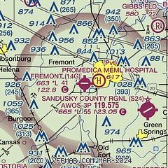
| Sectional chart |
|---|
|
| Airport distance calculator |
|---|
|
|
| Sunrise and sunset |
|---|
|
Times for 03-Jul-2026
| | Local
(UTC-4) | | Zulu
(UTC) |
|---|
| Morning civil twilight | | 05:32 | | 09:32 |
| Sunrise | | 06:05 | | 10:05 |
| Sunset | | 21:09 | | 01:09 |
| Evening civil twilight | | 21:42 | | 01:42 |
|
| Current date and time |
|---|
| Zulu (UTC) | 03-Jul-2026 19:44:36 |
|---|
| Local (UTC-4) | 03-Jul-2026 15:44:36 |
|---|
|
| METAR |
|---|
KPCW
17nm NE | 031935Z AUTO 35007KT 10SM SCT060 SCT085 33/24 A3001 RMK AO2
|
KTDZ
20nm NW | 031853Z AUTO 25010G16KT 200V270 10SM FEW055 34/22 A3004 RMK AO2 SLP166 T03440217
|
KFDY
30nm SW | 031853Z AUTO 26010KT 10SM SCT047 34/23 A3005 RMK AO2 SLP163 T03390233
|
KTOL
32nm NW | 031852Z 25010G18KT 10SM SCT050 SCT065 35/22 A3003 RMK AO2 SLP162 T03500217 $
|
KDUH
33nm NW | 031935Z AUTO 26010KT 10SM FEW060 35/21 A3001 RMK AO2
|
|
| TAF |
|---|
KFDY
30nm SW | 031732Z 0318/0418 24009G15KT P6SM SKC FM032300 26009KT P6SM VCSH BKN050 TEMPO 0400/0404 VRB20G40KT 2SM TSRA OVC025CB FM040500 26004KT P6SM SCT050
|
KTOL
32nm NW | 031136Z 0312/0412 24006KT P6SM BKN150 FM032000 25010KT P6SM VCSH SCT040 TEMPO 0321/0324 VRB20G40KT 2SM TSRA OVC025CB FM040200 26004KT P6SM SCT050
|
|
| NOTAMs |
|---|
NOTAMs are issued by the DoD/FAA and will open in a separate window not controlled by AirNav.
|
|


