FAA INFORMATION EFFECTIVE 16 APRIL 2026
Location
| FAA Identifier: | 17FL |
| Lat/Long: | 29-16-41.2650N 082-07-16.9850W
29-16.687750N 082-07.283083W
29.2781292,-82.1213847
(estimated) |
| Elevation: | 100 ft. / 30 m (estimated) |
| Variation: | 06W (2020) |
| From city: | 5 miles NE of OCALA, FL |
| Time zone: | UTC -4 (UTC -5 during Standard Time) |
| Zip code: | 34479 |
Airport Operations
| Airport use: | Private use. Permission required prior to landing |
| Activation date: | 10/1980 |
| Control tower: | no |
| ARTCC: | JACKSONVILLE CENTER |
| FSS: | GAINESVILLE FLIGHT SERVICE STATION |
| Attendance: | MON-FRI 0800-1700 |
| Wind indicator: | yes |
| Segmented circle: | no |
| Beacon: | white-green (lighted land airport)
Operates sunset to sunrise. |
| Landing fee: | yes |
Airport Communications
| CTAF/UNICOM: | 122.7 |
| WX AWOS-3PT at OCF (8 nm SW): | 128.125 (352-237-8525) |
| WX AWOS-3T at X60 (19 nm W): | 118.425 (352-528-9949) |
Nearby radio navigation aids
| VOR radial/distance | | VOR name | | Freq | | Var |
|---|
| OCFr042/8.2 | | OCALA VORTAC | | 113.70 | | 00E |
| GNVr166/26.1 | | GATORS VORTAC | | 116.55 | | 04W |
Airport Services
| Fuel available: | 100 JET-A JET-A+ |
Runway Information
Runway 18/36
| Dimensions: | 7380 x 190 ft. / 2249 x 58 m |
| Surface: | asphalt, in fair condition |
| Weight bearing capacity: | | Single wheel: | 68.0, MAX LNDG WT 60,000 LB SNGL WHEELS ALL OTRS PCN/ACN 22/F/B/X/T. | | Double wheel: | 100.0 |
|
| Runway edge lights: | medium intensity |
| RUNWAY 18 | | RUNWAY 36 |
| Latitude: | 29-17.247000N | | 29-16.030667N |
| Longitude: | 082-07.194667W | | 082-07.261333W |
| Elevation: | 100.0 ft. | | 75.0 ft. |
| Traffic pattern: | left | | left |
| Runway heading: | 189 magnetic, 183 true | | 009 magnetic, 003 true |
| Displaced threshold: | 907 ft. | | 1844 ft. |
| Markings: | basic, in fair condition | | basic, in fair condition |
| Visual slope indicator: | | | 2-box VASI on left |
| Touchdown point: | yes, no lights | | yes, no lights |
| Obstructions: | 12 ft. trees | | 18 ft. fence |
Runway 9/27
| Dimensions: | 3457 x 100 ft. / 1054 x 30 m |
| Surface: | turf, in fair condition |
| Operational restrictions: | RWY 09/27 CLSD INDEFLY. |
| RUNWAY 9 | | RUNWAY 27 |
| Latitude: | 29-16.792167N | | 29-16.792167N |
| Longitude: | 082-07.726000W | | 082-07.075333W |
| Elevation: | 100.0 ft. | | 100.0 ft. |
| Traffic pattern: | left | | left |
| Runway heading: | 096 magnetic, 090 true | | 276 magnetic, 270 true |
| Markings: | none, in fair condition | | none, in fair condition |
| Touchdown point: | yes, no lights | | yes, no lights |
| Obstructions: | pline, marked, 1000 ft. from runway | | trees, 900 ft. from runway |
Airport Ownership and Management from official FAA records
| Ownership: | Privately-owned |
| Owner: | JUMBOLAIR OPERATIONS, LLC
8400 NE JACKSONVILLE RD
OCALA, FL 34479
Phone 321-339-8902
1423 NE 77TH ST OCALA, FL 34479 |
| Manager: | JUMBOLAIR OPERATIONS, LLC
8400 NE JACKSONVILLE RD
OCALA, FL 34479-1162
Phone 321-339-8902 |
Additional Remarks
| A39-18/36 | PCR VALUE: 220/F/A/X/T |
| - | 1500 FT TOWER 2 MIS E AND 600 FT TOWER 2.0 MIS S. |
| - | FOR CD CTC JACKSONVILLE APCH AT 904-741-0284. |
Instrument Procedures
There are no published instrument procedures at 17FL.
Some nearby airports with instrument procedures:
KOCF - Ocala International Airport-Jim Taylor Field (8 nm SW)
X35 - Marion County Airport (19 nm SW)
X60 - Williston Regional Airport (19 nm W)
KGNV - Gainesville Regional Airport (26 nm N)
KINF - Inverness Airport (30 nm S)
|
|

Road maps at:
MapQuest
Bing
Google
| Aerial photo |
|---|
WARNING: Photo may not be current or correct
 Photo by Michael Caban
Taken in November 2005
Photo by Michael Caban
Taken in November 2005
Do you have a better or more recent aerial photo of Jumbolair Airport that you would like to share? If so, please send us your photo.
|
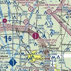
| Sectional chart |
|---|
|
| Airport distance calculator |
|---|
|
|
| Sunrise and sunset |
|---|
|
Times for 26-Apr-2026
| | Local
(UTC-4) | | Zulu
(UTC) |
|---|
| Morning civil twilight | | 06:27 | | 10:27 |
| Sunrise | | 06:52 | | 10:52 |
| Sunset | | 20:00 | | 00:00 |
| Evening civil twilight | | 20:25 | | 00:25 |
|
| Current date and time |
|---|
| Zulu (UTC) | 26-Apr-2026 23:18:42 |
|---|
| Local (UTC-4) | 26-Apr-2026 19:18:42 |
|---|
|
| METAR |
|---|
KOCF
8nm SW | 262251Z 26007KT 10SM CLR 27/19 A2985 RMK AO2 LTG DSNT E SLP107 T02720189
|
KX60
19nm W | 118.425 352-528-9949
260955Z AUTO 00000KT 10SM CLR 16/15 A2985 RMK AO2
|
|
| TAF |
|---|
KGNV
27nm N | 261757Z 2618/2718 28010G16KT P6SM VCTS SCT035CB SCT110 PROB30 2620/2623 VRB15G30KT 4SM -TSRA BR BKN035CB FM270300 33006KT P6SM FEW050 BKN100 FM271100 04007KT P6SM BKN035 FM271500 05012G20KT P6SM SCT015 BKN035
|
KLEE
32nm SE | 262208Z 2622/2718 27008KT P6SM VCSH SCT060 SCT100 FM270100 VRB06KT P6SM FEW060 SCT080 SCT250 FM271400 05010KT P6SM SCT040
|
|
| NOTAMs |
|---|
NOTAMs are issued by the DoD/FAA and will open in a separate window not controlled by AirNav.
|
|


