FAA INFORMATION EFFECTIVE 25 DECEMBER 2025
Location
| FAA Identifier: | GNV |
| Lat/Long: | 29-41-24.2000N 082-16-18.4000W
29-41.403333N 082-16.306667W
29.6900556,-82.2717778
(estimated) |
| Elevation: | 151.4 ft. / 46.1 m (surveyed) |
| Variation: | 04W (2005) |
| From city: | 3 miles NE of GAINESVILLE, FL |
| Time zone: | UTC -5 (UTC -4 during Daylight Saving Time) |
| Zip code: | 32609 |
Airport Operations
| Airport use: | Open to the public |
| Activation date: | 04/1940 |
| Control tower: | yes |
| ARTCC: | JACKSONVILLE CENTER |
| FSS: | GAINESVILLE FLIGHT SERVICE STATION |
| NOTAMs facility: | GNV (NOTAM-D service available) |
| Attendance: | CONTINUOUS |
| Wind indicator: | lighted |
| Segmented circle: | yes |
| Lights: | WHEN ATCT CLSD ACTVT MALSR RWY 29; MIRL RWY 07/25; HIRL RWY 11/29 - CTAF. |
| Beacon: | white-green (lighted land airport)
Operates sunset to sunrise. |
| Fire and rescue: | ARFF index B |
| Airline operations: | RWY 7/25 NOT AVBL FOR SKED ACR OPS WITH MORE THAN 9 PAX SEATS OR UNSKED ACR AT LEAST 31 PAX SEATS. |
Airport Communications
| CTAF: | 119.55 |
| UNICOM: | 122.95 |
| ATIS: | 127.15 |
| WX ASOS: | 127.15 (352-335-8672) |
| GAINESVILLE GROUND: | 121.7 [0645-2230] |
| GAINESVILLE TOWER: | 119.55 353.7 [0645-2230] |
| JACKSONVILLE APPROACH: | 118.175 ;10000 FT & BLW |
| JACKSONVILLE DEPARTURE: | 118.175 ;10000 FT & BLW |
| WX AWOS-3 at 42J (15 nm NE): | 124.275 (352-473-8273) |
Nearby radio navigation aids
| VOR radial/distance | | VOR name | | Freq | | Var |
|---|
| GNV at field | | GATORS VORTAC | | 116.55 | | 04W |
| OCFr356/30.8 | | OCALA VORTAC | | 113.70 | | 00E |
| NDB name | | Hdg/Dist | | Freq | | Var | | ID |
|---|
| REYNOLDS | | 250/36.0 | | 338 | | 07W | | RYD | .-. -.-- -.. |
Airport Services
| Fuel available: | 100 JET-A |
| Parking: | hangars and tiedowns |
| Airframe service: | MAJOR |
| Powerplant service: | MAJOR |
| Bottled oxygen: | HIGH |
| Bulk oxygen: | HIGH |
Runway Information
Runway 11/29
| Dimensions: | 7504 x 150 ft. / 2287 x 46 m |
| Surface: | asphalt/grooved, in good condition
STD GROOVING FULL LENGTH AND 130 FT WIDE CENTER PORTION. |
| Weight bearing capacity: | | Single wheel: | 118.0 | | Double wheel: | 195.0 | | Double tandem: | 331.0 | | Dual double tandem: | 796.0 |
|
| Runway edge lights: | high intensity |
| RUNWAY 11 | | RUNWAY 29 |
| Latitude: | 29-41.433435N | | 29-41.170223N |
| Longitude: | 082-16.835913W | | 082-15.450460W |
| Elevation: | 147.4 ft. | | 105.1 ft. |
| Traffic pattern: | left | | left |
| Runway heading: | 106 magnetic, 102 true | | 286 magnetic, 282 true |
| Markings: | precision, in good condition | | precision, in good condition |
| Visual slope indicator: | 4-light PAPI on left (3.00 degrees glide path) | | 4-light PAPI on right (3.00 degrees glide path) |
| RVR equipment: | rollout | | touchdown |
| Approach lights: | | | MALSR: 1,400 foot medium intensity approach lighting system with runway alignment indicator lights |
| Runway end identifier lights: | yes | | |
| Touchdown point: | yes, no lights | | yes, no lights |
| Instrument approach: | | | ILS |
| Obstructions: | 81 ft. trees, 2783 ft. from runway, 626 ft. right of centerline, 31:1 slope to clear | | 68 ft. trees, 3535 ft. from runway, 458 ft. left of centerline, 49:1 slope to clear |
Runway 7/25
| Dimensions: | 4158 x 100 ft. / 1267 x 30 m |
| Surface: | asphalt/grooved, in fair condition |
| Weight bearing capacity: | | Single wheel: | 83.0 | | Double wheel: | 137.0 | | Double tandem: | 227.0 |
|
| Runway edge lights: | medium intensity |
| Operational restrictions: | RWY 07/25 NOT AVBL FOR PART 121/PART 380 OPS WITH SKED PAX CARRYING OPS MORE THAN 9 PAX SEATS AND NON-SKED PAX CARRYING OPS MORE THAN 30 PAX SEATS. |
| RUNWAY 7 | | RUNWAY 25 |
| Latitude: | 29-41.418368N | | 29-41.750638N |
| Longitude: | 082-16.943497W | | 082-16.256110W |
| Elevation: | 151.4 ft. | | 130.2 ft. |
| Traffic pattern: | left | | left |
| Runway heading: | 065 magnetic, 061 true | | 245 magnetic, 241 true |
| Markings: | nonprecision, in good condition | | nonprecision, in good condition |
| Visual slope indicator: | 4-light PAPI on left (3.00 degrees glide path) | | 4-light PAPI on left (3.00 degrees glide path) |
| Runway end identifier lights: | no | | |
| Touchdown point: | yes, no lights | | yes, no lights |
| Obstructions: | 70 ft. trees, 2006 ft. from runway, 432 ft. left of centerline, 25:1 slope to clear | | 34 ft. trees, 1389 ft. from runway, 423 ft. left of centerline, 34:1 slope to clear |
Airport Ownership and Management from official FAA records
| Ownership: | Publicly-owned |
| Owner: | GAINESVILLE-ALACHUA CO AUTH
3880 NE 39TH AVE
GAINESVILLE, FL 32609
Phone 352-373-0249
GAINESVILLE-ALACHUA CO REGIONAL ARPT AUTHORITY |
| Manager: | ALLAN PENKSA
3880 NE 39 AVE STE A
GAINESVILLE, FL 32609
Phone 352-373-0249 |
Additional Remarks
| A39-11/29 | PCR VALUE: 480/F/B/X/T |
| A39-07/25 | PCR VALUE: 320/F/B/X/T |
| - | WHEN ATCT CLSD ACFT MORE THAN 12500 LBS CTC FBO FOR PRKG INSTR PRIOR TO EXITING TWY A DUE TO IREG PAVEMENT STRENGTHS - 352-335-4681. |
| - | GA RAMP LMTD TO ACFT 110,000 LB OR BLW; OTHERS PPR. |
| - | BANNER TOWING NA EXC 72 HR PPR - AMGR. |
| - | ARPT SFC COND NOT MNTD BTW 2330 - 0400 DLY. |
| - | FOR CD IF UNA TO CTC ON FSS FREQ, CTC JACKSONVILLE APCH AT 904-741-0284. |
| - | RWY 11-29 MRKGS ON W END ARE NOT STD DUE TO MRKGS NOT FULLY REMOVED/GHOSTING. |
| - | TWY B LMTD TO 75,000 LB OR BLW; OTHERS PPR |
| - | TWY C LMTD TO 120,000 LB OR BLW; OTHERS PPR |
| - | TWY D LMTD TO 120,000 LB OR BLW; OTHERS PPR |
| - | ACFT EQUIPPED WITH WX MODIFICATION OR GEOENGINEERING EQPT CTC ARPT OPS 352-262-6691. |
| - | PORTIONS OF RWY 07/25 & NE 1000 FT OF TWY A NOT VSB FM ATCT; BLOCKED BY VORTAC BLDG. |
| - | WILDLIFE ON & INVOF ARPT. |
Instrument Procedures
NOTE: All procedures below are presented as PDF files. If you need a reader for these files, you should download the free Adobe Reader.NOT FOR NAVIGATION. Please procure official charts for flight.
FAA instrument procedures published for use from 25 December 2025 at 0901z to 22 January 2026 at 0900z.
IAPs - Instrument Approach Procedures |
|---|
| ILS OR LOC RWY 29 | |
download (294KB) |
| RNAV (GPS) RWY 07 | |
download (240KB) |
| RNAV (GPS) RWY 11 | |
download (276KB) |
| RNAV (GPS) RWY 25 | |
download (269KB) |
| RNAV (GPS) RWY 29 | |
download (299KB) |
| NOTE: Special Alternate Minimums apply | |
download (127KB) |
| NOTE: Special Take-Off Minimums/Departure Procedures apply | |
download (162KB) |
Other nearby airports with instrument procedures:
42J - Keystone Heights Airport (15 nm NE)
X60 - Williston Regional Airport (23 nm SW)
28J - Palatka Municipal Airport/Lt. Kay Larkin Field (30 nm E)
KOCF - Ocala International Airport-Jim Taylor Field (31 nm S)
KLCQ - Lake City Gateway Airport (34 nm NW)
|
|

Road maps at:
MapQuest
Bing
Google
| Aerial photo |
|---|
WARNING: Photo may not be current or correct
 Photo taken 26-Nov-2017
looking east-northeast.
Photo taken 26-Nov-2017
looking east-northeast.
Do you have a better or more recent aerial photo of Gainesville Regional Airport that you would like to share? If so, please send us your photo.
|
| Sectional chart |
|---|
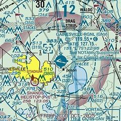
|
 Download PDF
of official airport diagram from the FAA
| Airport distance calculator |
|---|
|
|
| Sunrise and sunset |
|---|
|
Times for 10-Jan-2026
| | Local
(UTC-5) | | Zulu
(UTC) |
|---|
| Morning civil twilight | | 07:01 | | 12:01 |
| Sunrise | | 07:27 | | 12:27 |
| Sunset | | 17:47 | | 22:47 |
| Evening civil twilight | | 18:13 | | 23:13 |
|
| Current date and time |
|---|
| Zulu (UTC) | 10-Jan-2026 16:01:51 |
|---|
| Local (UTC-5) | 10-Jan-2026 11:01:51 |
|---|
|
| METAR |
|---|
| KGNV | 101553Z 18009G17KT 10SM SCT014 24/19 A3021 RMK AO2 SLP227 T02440194
|
K42J
15nm NE | 101555Z AUTO 20012KT 10SM BKN015 24/20 A3018 RMK A01
|
|
| TAF |
|---|
| KGNV | 101258Z 1013/1112 16003KT 1/4SM FG BKN002 TEMPO 1013/1014 2SM BR SCT004 SCT250 FM101400 20008KT P6SM FEW015 FEW050 SCT250 FM101900 23011KT P6SM SCT050 FM102300 25005KT P6SM FEW050
|
|
| NOTAMs |
|---|
NOTAMs are issued by the DoD/FAA and will open in a separate window not controlled by AirNav.
|
|


