FAA INFORMATION EFFECTIVE 11 JUNE 2026
Location
| FAA Identifier: | 20T |
| Lat/Long: | 32-28-14.5010N 097-33-37.0820W
32-28.241683N 097-33.618033W
32.4706947,-97.5603006
(estimated) |
| Elevation: | 985 ft. / 300 m (estimated) |
| Variation: | 07E (1985) |
| From city: | 2 miles NW of GODLEY, TX |
| Time zone: | UTC -5 (UTC -6 during Standard Time) |
| Zip code: | 76044 |
Airport Operations
| Airport use: | Open to the public |
| Activation date: | 07/1987 |
| Control tower: | no |
| ARTCC: | FORT WORTH CENTER |
| FSS: | FORT WORTH FLIGHT SERVICE STATION |
| NOTAMs facility: | FTW (NOTAM-D service not available) |
| Attendance: | CONTINUOUS |
| Wind indicator: | lighted |
| Segmented circle: | no |
| Landing fee: | yes |
Airport Communications
| CTAF: | 122.9 |
| WX AWOS-3 at CPT (10 nm SE): | 119.525 (817-641-4135) |
| WX AWOS-3PT at GDJ (13 nm W): | 118.925 (817-573-7514) |
| WX AWOS-3PT at FWS (14 nm NE): | 120.025 (817-426-4172) |
Nearby radio navigation aids
| VOR radial/distance | | VOR name | | Freq | | Var |
|---|
| MQPr116/26.9 | | MILLSAP VORTAC | | 117.70 | | 09E |
| FUZr211/31.6 | | RANGER VORTAC | | 115.70 | | 06E |
| TTTr222/35.5 | | MAVERICK VOR/DME | | 113.10 | | 06E |
Airport Services
Runway Information
Runway 14/32
| Dimensions: | 2500 x 60 ft. / 762 x 18 m |
| Surface: | turf, in good condition |
| RUNWAY 14 | | RUNWAY 32 |
| Traffic pattern: | right | | right |
| Obstructions: | 30 ft. pline, 115 ft. right of centerline
ALSO 26 FT RR, PARALLEL TO RWY FULL LENGTH. | | 30 ft. pline, 87 ft. left of centerline |
Airport Ownership and Management from official FAA records
| Ownership: | Privately-owned |
| Owner: | ARESTI AERODROME, INC.
10137 CR 1001
GODLEY, TX 76044
Phone 817-648-9193 |
| Manager: | SHELTON STEWART
10141 COUNTY RD 1001
GODLEY, TX 76044
Phone 817-304-4658
SHELTONSAF@GMAIL.COM; JEFF CAIN 817-966-8083, CAINJFTW@YAHOO.COM; DAN CLARK 682-262-4669. |
Additional Remarks
| - | FOR CD CTC LONE STAR APCH AT 972-615-2799. |
| - | PILOTS RQD TO CTC ARPT OPNS AT 817-304-4658 FOR SAFETY BRIEF AND LDG AUTH. |
| - | 30 FT UNMKD PLINE, PARALLEL TO & 60 FT SW OF RWY EDGE, FULL LENGTH, PARTIALLY OBSCURED BY TREES. |
| - | THREE 60 FT ANTENNAS, 145 FT NE OF RWY EDGE, MID-FIELD. |
| - | AEROBATIC BOX 1 MI NORTH OF RWY 14 THR, 300 FT AGL TO 3500 FT AGL. |
| - | NOISE SENSITVE AREA 1 MI WEST OF AER 14. |
| - | STUDENT TRNG PPR. |
| - | DO NOT TAXI ON NON-MOWED AREAS. |
| - | THE FLWG OPNS PROHIBITED: ULTRALIGHTS, PWRD PRCHTS, SAILPLANES, AUTO-GYROS, PAJA, AG OPNS, AIRSHIPS. |
| - | UNCTLD VEHICLE TFC INVOF HNGRS AND RWY. |
| - | FQT MOWING OPNS. |
| - | ARPT SFC COND NOT RPRTD. PPR 30 MIN PRIOR AT 817-304-4658. |
Instrument Procedures
There are no published instrument procedures at 20T.
Some nearby airports with instrument procedures:
50F - Bourland Field Airport (7 nm N)
KCPT - Cleburne Regional Airport (10 nm SE)
KGDJ - Granbury Regional Airport (13 nm W)
KFWS - Fort Worth Spinks Airport (14 nm NE)
KWEA - Parker County Airport (18 nm N)
KNFW - Fort Worth Naval Air Station JRB (Carswell Field) Airport (19 nm N)
|
|

Road maps at:
MapQuest
Bing
Google
| Aerial photo |
|---|

|
| Sectional chart |
|---|
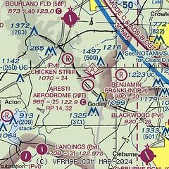
|
| Airport distance calculator |
|---|
|
|
| Sunrise and sunset |
|---|
|
Times for 21-Jun-2026
| | Local
(UTC-5) | | Zulu
(UTC) |
|---|
| Morning civil twilight | | 05:56 | | 10:56 |
| Sunrise | | 06:24 | | 11:24 |
| Sunset | | 20:40 | | 01:40 |
| Evening civil twilight | | 21:08 | | 02:08 |
|
| Current date and time |
|---|
| Zulu (UTC) | 21-Jun-2026 23:52:05 |
|---|
| Local (UTC-5) | 21-Jun-2026 18:52:05 |
|---|
|
| METAR |
|---|
KCPT
10nm SE | 212335Z AUTO 17014G21KT 10SM CLR 32/25 A2968 RMK AO2 T03250245 $
|
KGDJ
13nm W | AWOS-3 118.925 817-573-7514
212335Z AUTO 18016G23KT 10SM CLR 34/22 A2969 RMK AO2
|
KFWS
14nm NE | 212253Z 17013KT 10SM CLR 33/24 A2974
|
KNFW
19nm N | 212152Z 17016G21KT 10SM FEW040 FEW049 33/23 A2975 RMK AO2 SLP058 T03330233 CHINO S VISNO S $
|
|
| NOTAMs |
|---|
NOTAMs are issued by the DoD/FAA and will open in a separate window not controlled by AirNav.
|
|


