FAA INFORMATION EFFECTIVE 14 MAY 2026
Location
| FAA Identifier: | 21F |
| Lat/Long: | 33-13-40.3000N 098-08-47.2000W
33-13.671667N 098-08.786667W
33.2278611,-98.1464444
(estimated) |
| Elevation: | 1062 ft. / 324 m (estimated) |
| Variation: | 07E (1985) |
| From city: | 1 mile NE of JACKSBORO, TX |
| Time zone: | UTC -5 (UTC -6 during Standard Time) |
| Zip code: | 76458 |
Airport Operations
| Airport use: | Open to the public |
| Activation date: | 03/1968 |
| Control tower: | no |
| ARTCC: | FORT WORTH CENTER |
| FSS: | FORT WORTH FLIGHT SERVICE STATION |
| NOTAMs facility: | FTW (NOTAM-D service available) |
| Attendance: | UNATND |
| Wind indicator: | lighted |
| Segmented circle: | yes |
| Lights: | SS-SR |
| Beacon: | white-green (lighted land airport)
Operates sunset to sunrise. |
Airport Communications
| CTAF: | 122.9 |
| WX AWOS-3PT at XBP (16 nm E): | 119.225 (940-683-8027) |
Nearby radio navigation aids
| VOR radial/distance | | VOR name | | Freq | | Var |
|---|
| UKWr215/24.6 | | BOWIE VORTAC | | 117.15 | | 06E |
| MQPr337/31.0 | | MILLSAP VORTAC | | 117.70 | | 09E |
Airport Services
| Fuel available: | 100LL |
| Parking: | tiedowns |
| Bottled oxygen: | NONE |
| Bulk oxygen: | NONE |
Runway Information
Runway 18/36
| Dimensions: | 3220 x 75 ft. / 981 x 23 m |
| Surface: | asphalt, in good condition |
| Weight bearing capacity: | |
| Runway edge lights: | medium intensity |
| RUNWAY 18 | | RUNWAY 36 |
| Latitude: | 33-13.936885N | | 33-13.406852N |
| Longitude: | 098-08.765978W | | 098-08.805815W |
| Elevation: | 1022.0 ft. | | 1062.0 ft. |
| Traffic pattern: | left | | left |
| Runway heading: | 177 magnetic, 184 true | | 357 magnetic, 004 true |
| Markings: | basic, in fair condition | | basic, in fair condition |
| Obstructions: | 67 ft. pole, 1500 ft. from runway, 19:1 slope to clear
10 FT TREES, 20-199 FT DSTC, 115 L. | | 20 ft. trees, 201 ft. from runway, 30 ft. left of centerline
15 FT TREES, 0-199 FT DSTC. |
Airport Ownership and Management from official FAA records
| Ownership: | Publicly-owned |
| Owner: | CITY OF JACKSBORO
112 WEST BELKNAP
JACKSBORO, TX 76458
Phone 940-567-6321 |
| Manager: | JESSE MAXWELL
112 WEST BELKNAP
JACKSBORO, TX 76458
Phone 940-507-3147
FOR AFTR HRS ASSISTANCE, CTC CENTRAL DISPATCH 940-567-2161. |
Additional Remarks
| - | ARPT GATE LOCKED-COMBINATION 1581. |
| - | PILOT LOUNGE/RESTROOM ACCESS 1200. |
| - | BIRDS ON AND INVOF ARPT. |
| - | COURTESY CAR AVBL. NEXT TO FUEL PUMP, KEYBOX ON NW POLE, CODE 1581. CALL 940-507-3147 TO RES OR USE CAR. |
| - | 6 FT OPEN DRAINAGE DITCH NEAR RWY 18 THR, 81 FT EAST OF CNTRLN ON BOTH SIDES OF TWY. |
| - | 5 FT OPEN DRAINAGE DITCH 84 FT EAST OF RWY 18 CNTRLN ON BOTH SIDES OF RAMP SOUTH TWY. |
Instrument Procedures
There are no published instrument procedures at 21F.
Some nearby airports with instrument procedures:
KXBP - Bridgeport Municipal Airport (16 nm E)
KRPH - Graham Municipal Airport (22 nm W)
F35 - Possum Kingdom Airport (23 nm SW)
KMWL - Mineral Wells Regional Airport (27 nm S)
KLUD - Decatur Municipal Airport (28 nm E)
|
|

Road maps at:
MapQuest
Bing
Google
| Aerial photo |
|---|
WARNING: Photo may not be current or correct
 Photo courtesy of Civil Air Patrol
Photo taken 16-Sep-2006
Photo courtesy of Civil Air Patrol
Photo taken 16-Sep-2006
Do you have a better or more recent aerial photo of Jacksboro Municipal Airport that you would like to share? If so, please send us your photo.
|
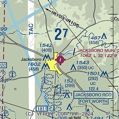
| Sectional chart |
|---|
|
| Airport distance calculator |
|---|
|
|
| Sunrise and sunset |
|---|
|
Times for 09-Jun-2026
| | Local
(UTC-5) | | Zulu
(UTC) |
|---|
| Morning civil twilight | | 05:55 | | 10:55 |
| Sunrise | | 06:24 | | 11:24 |
| Sunset | | 20:40 | | 01:40 |
| Evening civil twilight | | 21:08 | | 02:08 |
|
| Current date and time |
|---|
| Zulu (UTC) | 09-Jun-2026 05:18:05 |
|---|
| Local (UTC-5) | 09-Jun-2026 00:18:05 |
|---|
|
| METAR |
|---|
KXBP
16nm E | 090430Z AUTO 19007KT CLR 27/22 A2998 RMK AO2 T02710215 PWINO
|
KRPH
22nm W | 090455Z AUTO 17009KT 120V200 10SM CLR 27/22 A2994 RMK AO2 T02750222 $
|
KMWL
27nm S | 090453Z AUTO 16011KT 10SM CLR 27/22 A2995 RMK AO2 SLP127 T02670222
|
KLUD
28nm E | 118.22 940-927-2365
090455Z AUTO 18012G18KT 10SM CLR 27/22 A2997 RMK AO2 T02730221
|
K0F2
29nm NE | 090455Z AUTO 17013G19KT 10SM CLR 27/23 A2995 RMK AO2 T02660233
|
|
| TAF |
|---|
KAFW
45nm E | 090256Z 0903/0924 18016KT P6SM FEW035 FM090900 19011KT P6SM BKN015 FM091600 18015KT P6SM SCT040
|
KNFW
45nm SE | 0823/0923 19018G25KT 9999 FEW050 FEW250 510008 QNH2983INS FM090400 19012KT 9999 FEW250 500000 QNH2992INS FM090800 19012KT 9999 BKN018 QNH2999INS FM091700 19012G22KT 9999 SCT040 SCT200 QNH2992INS AUTOMATED SENSOR METWATCH 0904 TIL 0911 TX34/0922Z TN23/0912Z FN20048
|
KFTW
46nm SE | 090256Z 0903/0924 18016KT P6SM FEW035 FM090900 19011KT P6SM BKN015 FM091600 18015KT P6SM SCT040
|
KSPS
49nm N | 090247Z 0903/0924 18013KT P6SM FEW250 FM091400 20016G22KT P6SM SCT250
|
|
| NOTAMs |
|---|
NOTAMs are issued by the DoD/FAA and will open in a separate window not controlled by AirNav.
|
|


