FAA INFORMATION EFFECTIVE 09 JULY 2026
Location
| FAA Identifier: | AFW |
| Lat/Long: | 32-59-25.1040N 097-19-09.9460W
32-59.418400N 097-19.165767W
32.9903067,-97.3194294
(estimated) |
| Elevation: | 723.2 ft. / 220.4 m (surveyed) |
| Variation: | 04E (2015) |
| From city: | 14 miles N of FORT WORTH, TX |
| Time zone: | UTC -5 (UTC -6 during Standard Time) |
| Zip code: | 76177 |
Airport Operations
| Airport use: | Open to the public |
| Activation date: | 12/1989 |
| Control tower: | yes |
| ARTCC: | FORT WORTH CENTER |
| FSS: | FORT WORTH FLIGHT SERVICE STATION |
| NOTAMs facility: | AFW (NOTAM-D service available) |
| Attendance: | CONTINUOUS |
| Wind indicator: | lighted |
| Segmented circle: | yes |
| Lights: | SS-SR |
| Beacon: | white-green (lighted land airport)
Operates sunset to sunrise. |
| Fire and rescue: | ARFF index E |
| Airline operations: | PPR FOR ACR OPNS WITH MORE THAN 30 PSGR SEATS CALL 817-890-1000 OR 800-318-9268. |
| International operations: | US CUSTOMS USER FEE ARPT. |
Airport Communications
| ATIS: | 126.925 |
| WX ASOS: | PHONE 817-491-6188 |
| ALLIANCE GROUND: | 132.65 306.2 |
| ALLIANCE TOWER: | 120.825 ;HELICOPTERS 135.15 257.9 |
| LONE STAR APPROACH: | 118.1 |
| LONE STAR DEPARTURE: | 118.1 |
| CLEARANCE DELIVERY: | 128.725 |
| BOTCH DP: | 118.1 |
| DALLAS AREA DP: | 118.1 |
| DODJE STAR: | 125.2 125.9 |
| GARLAND DP: | 118.1 |
| JOE POOL DP: | 118.1 |
| LIKES STAR: | 125.8 ;SOUTH 135.975 ;NORTH |
| MOTZA STAR: | 118.1 ;SOUTH 125.8 ;NORTH |
| NANDR RNAV DP: | 118.1 |
| REEKO STAR: | 125.2 |
| SASIE STAR: | 124.3 |
| TRUUK RNAV STAR: | 124.3 |
| WESAT STAR: | 118.1 ;SOUTH 125.8 ;NORTH |
| WX ASOS at FTW (10 nm S): | PHONE 817-740-3346 |
| WX ASOS at DTO (14 nm NE): | 119.325 (940-354-2971) |
| WX ASOS at DFW (15 nm E): | PHONE 214-600-7784 |
- ARINC FREQ 129.75 AVBL.
- EMERGENCY FREQ NOT AVBL.
- SAID IN USE. OPERATE TRANSPONDERS WITH ALTITUDE REPORTING MODE AND ADS-B (IF EQUIPPED) ENABLED ON ALL AIRPORT SURFACES.
Nearby radio navigation aids
| VOR radial/distance | | VOR name | | Freq | | Var |
|---|
| FUZr305/9.3 | | RANGER VORTAC | | 115.70 | | 06E |
| TTTr291/15.8 | | MAVERICK VOR/DME | | 113.10 | | 06E |
| CVEr280/21.8 | | COWBOY VOR/DME | | 116.20 | | 06E |
| MQPr056/37.7 | | MILLSAP VORTAC | | 117.70 | | 09E |
| NDB name | | Hdg/Dist | | Freq | | Var | | ID |
|---|
| MUFIN | | 017/6.4 | | 365 | | 08E | | FT | ..-. - |
Airport Services
| Fuel available: | 100LL JET-A1+ |
| Parking: | hangars and tiedowns |
| Airframe service: | MAJOR
PRIOR ARRANGEMENTS REQUIRED FOR AIRFRAME OR POWER PLANT REPAIRS FOR DESIGN GROUP III & ABOVE. |
| Powerplant service: | MAJOR |
| Bottled oxygen: | LOW |
Runway Information
Runway 16R/34L
| Dimensions: | 11125 x 150 ft. / 3391 x 46 m |
| Surface: | concrete/grooved, in good condition |
| Weight bearing capacity: | | Double wheel: | 200.0 | | Double tandem: | 400.0 | | Dual double tandem: | 870.0 |
|
| Runway edge lights: | high intensity |
| RUNWAY 16R | | RUNWAY 34L |
| Latitude: | 33-00.308878N | | 32-58.501110N |
| Longitude: | 097-19.407327W | | 097-19.037282W |
| Elevation: | 721.2 ft. | | 664.7 ft. |
| Traffic pattern: | right | | left |
| Runway heading: | 166 magnetic, 170 true | | 346 magnetic, 350 true |
| Displaced threshold: | no | | 716 ft. |
| Declared distances: | TORA:11010 TODA:11010 ASDA:10410 LDA:10410 | | TORA:11010 TODA:11010 ASDA:11010 LDA:10409 |
| Markings: | precision, in good condition | | precision, in good condition |
| Visual slope indicator: | 4-light PAPI on right (3.00 degrees glide path) | | 4-light PAPI on left (3.00 degrees glide path) |
| Runway end identifier lights: | yes | | yes |
| Touchdown point: | yes, no lights | | yes, no lights |
| Obstructions: | 19 ft. rr, 607 ft. from runway, 287 ft. right of centerline, 21:1 slope to clear
APCH RATIO 0:1 BASED ON DSPLCD THLD; +5 FT FENCE 0 FT, 250 FT R. | | 4 ft. fence, 200 ft. from runway, 250 ft. left of centerline
+4 FT FENCE 0 FT 250 FT L; APCH RATIO 0:1 BASED ON DSPLCD THLD. |
Runway 16L/34R
| Dimensions: | 11000 x 150 ft. / 3353 x 46 m |
| Surface: | concrete/grooved, in good condition |
| Weight bearing capacity: | | Double wheel: | 200.0 | | Double tandem: | 400.0 | | Dual double tandem: | 870.0 |
|
| Runway edge lights: | high intensity |
| RUNWAY 16L | | RUNWAY 34R |
| Latitude: | 33-00.325685N | | 32-58.538248N |
| Longitude: | 097-19.291575W | | 097-18.925727W |
| Elevation: | 723.1 ft. | | 664.2 ft. |
| Traffic pattern: | right | | left |
| Runway heading: | 166 magnetic, 170 true | | 346 magnetic, 350 true |
| Declared distances: | TORA:11000 TODA:11000 ASDA:10600 LDA:10600 | | TORA:11000 TODA:11000 ASDA:11000 LDA:11000 |
| Markings: | precision, in good condition | | precision, in good condition |
| RVR equipment: | touchdown, midfield, rollout | | touchdown, midfield, rollout |
| Approach lights: | ALSF2: standard 2,400 foot high intensity approach lighting system with centerline sequenced flashers (category II or III) | | MALSR: 1,400 foot medium intensity approach lighting system with runway alignment indicator lights |
| Centerline lights: | yes | | yes |
| Touchdown point: | yes, lighted | | yes, lighted |
| Instrument approach: | ILS/DME | | ILS/DME |
| Obstructions: | none | | 182 ft. pline, lighted, 7920 ft. from runway, 590 ft. right of centerline, 42:1 slope to clear |
Airport Ownership and Management from official FAA records
| Ownership: | Publicly-owned |
| Owner: | CITY OF FORT WORTH
1000 THROCKMORTON
FORT WORTH, TX 76177
Phone 817-392-6116 |
| Manager: | CHRISTOPHER ASH
13901 AVIATOR WAY
FORT WORTH, TX 76177
Phone 817-890-1000 |
Additional Remarks
| A39-16L/34R | PCR VALUE: 786/R/B/W/T |
| A39-16R/34L | PCR VALUE: 786/R/B/W/T |
| - | FLIGHT NOTIFICATION SERVICE (ADCUS) AVBL. |
| - | PORTIONS OF TWY H MOVEMENT AREA EAST OF TWY A IS NOT VISIBLE FROM ATCT. |
Instrument Procedures
NOTE: All procedures below are presented as PDF files. If you need a reader for these files, you should download the free Adobe Reader.NOT FOR NAVIGATION. Please procure official charts for flight.
FAA instrument procedures published for use from 09 July 2026 at 0901Z to 06 August 2026 at 0900Z.
STARs - Standard Terminal Arrivals |
|---|
| DODJE SIX **NEW** | |
2 pages:
[1] [2] (673KB) |
| LIKES FOUR (RNAV) **NEW** | |
download (192KB) |
| MOTZA ONE **NEW** | |
2 pages:
[1] [2] (424KB) |
| REEKO THREE (RNAV) **NEW** | |
download (214KB) |
| SASIE EIGHT **NEW** | |
2 pages:
[1] [2] (437KB) |
| TRUUK THREE (RNAV) **NEW** | |
download (198KB) |
| WESAT THREE (RNAV) **NEW** | |
download (210KB) |
IAPs - Instrument Approach Procedures |
|---|
| ILS OR LOC RWY 16L | |
download (299KB) |
| ILS OR LOC RWY 34R | |
download (293KB) |
| ILS RWY 16L (CAT II - III) | |
download (250KB) |
| RNAV (GPS) RWY 16L | |
download (266KB) |
| RNAV (GPS) RWY 16R | |
download (251KB) |
| RNAV (GPS) RWY 34R | |
download (244KB) |
| NOTE: Special Alternate Minimums apply | |
download (139KB) |
Departure Procedures |
|---|
| BOTCH TWO (RNAV) **NEW** | |
2 pages:
[1] [2] (401KB) |
| DALLAS FOUR | |
2 pages:
[1] [2] (378KB) |
| GARLAND SIX | |
2 pages:
[1] [2] (374KB) |
| JOE POOL EIGHT | |
2 pages:
[1] [2] (493KB) |
| KINGDOM FIVE | |
2 pages:
[1] [2] (399KB) |
| KUSSO THREE (RNAV) **NEW** | |
2 pages:
[1] [2] (375KB) |
| NANDR FOUR (RNAV) **NEW** | |
2 pages:
[1] [2] (385KB) |
| TEXOMA FIVE | |
2 pages:
[1] [2] (484KB) |
| WORTH ONE | |
2 pages:
[1] [2] (464KB) |
| NOTE: Special Take-Off Minimums/Departure Procedures apply | |
download (305KB) |
Other nearby airports with instrument procedures:
4T2 - Kenneth Copeland Airport (9 nm W)
KFTW - Fort Worth Meacham International Airport (10 nm S)
KDTO - Denton Enterprise Airport (14 nm NE)
KNFW - Fort Worth Naval Air Station JRB (Carswell Field) Airport (15 nm SW)
KDFW - Dallas-Fort Worth International Airport (15 nm E)
|
|

Road maps at:
MapQuest
Bing
Google
| Aerial photo |
|---|
WARNING: Photo may not be current or correct
 Taken in April 2024
looking north.
Taken in April 2024
looking north.
Do you have a better or more recent aerial photo of Perot Field/Fort Worth Alliance Airport that you would like to share? If so, please send us your photo.
|
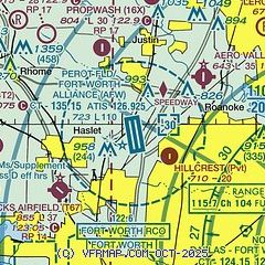
| Sectional chart |
|---|
|
CAUTION: Diagram may not be current
 Download PDF
of official airport diagram from the FAA
| Airport distance calculator |
|---|
|
|
| Sunrise and sunset |
|---|
|
Times for 11-Jul-2026
| | Local
(UTC-5) | | Zulu
(UTC) |
|---|
| Morning civil twilight | | 06:02 | | 11:02 |
| Sunrise | | 06:30 | | 11:30 |
| Sunset | | 20:39 | | 01:39 |
| Evening civil twilight | | 21:08 | | 02:08 |
|
| Current date and time |
|---|
| Zulu (UTC) | 11-Jul-2026 22:20:12 |
|---|
| Local (UTC-5) | 11-Jul-2026 17:20:12 |
|---|
|
| METAR |
|---|
| KAFW | 112153Z 14012G21KT 10SM SCT065 BKN085 BKN250 36/19 A2997 RMK AO2 SLP130 T03610194 $
|
KFTW
10nm S | 112053Z 16009KT 130V190 10SM FEW001 SCT060 37/21 A2997 RMK AO2 SLP138 T03670206 58018 $
|
KDTO
14nm NE | 112153Z 14012G19KT 10SM CLR 36/21 A2997 RMK AO2 SLP138 T03610206
|
KNFW
15nm SW | 112152Z 17010KT 10SM SCT065 37/19 A2997 RMK AO2 SLP132 T03670194
|
KDFW
16nm E | 112153Z 14012G19KT 10SM SCT060 SCT250 36/19 A2996 RMK AO2 SLP135 T03610194 $
|
|
| TAF |
|---|
| KAFW | 111720Z 1118/1218 19012KT P6SM SCT250
|
KFTW
10nm S | 111958Z 1120/1218 16011KT P6SM SCT250
|
KNFW
15nm SW | 111500Z 1115/1215 19009G20KT 9999 BKN070 QNH2993INS AUTOMATED SENSOR METWATCH 1122 TIL 1211 TX37/1122Z TN26/1211Z FN20070
|
KDFW
16nm E | 111720Z 1118/1224 19012KT P6SM SCT250 FM122000 16012KT P6SM VCTS SCT050CB BKN100
|
|
| NOTAMs |
|---|
NOTAMs are issued by the DoD/FAA and will open in a separate window not controlled by AirNav.
|
|


