FAA INFORMATION EFFECTIVE 22 JANUARY 2026
Location
| FAA Identifier: | 21W |
| Lat/Long: | 47-00-47.3000N 121-32-01.2000W
47-00.788333N 121-32.020000W
47.0131389,-121.5336667
(estimated) |
| Elevation: | 2650 ft. / 808 m (estimated) |
| Variation: | 19E (1995) |
| From city: | 10 miles SE of GREENWATER, WA |
| Time zone: | UTC -8 (UTC -7 during Daylight Saving Time) |
| Zip code: | 98022 |
Airport Operations
| Airport use: | Open to the public |
| Activation date: | 03/1997 |
| Control tower: | no |
| ARTCC: | SEATTLE CENTER |
| FSS: | SEATTLE FLIGHT SERVICE STATION |
| NOTAMs facility: | SEA (NOTAM-D service available) |
| Attendance: | UNATNDD |
| Wind indicator: | yes |
| Segmented circle: | no |
Airport Communications
Airport Services
Runway Information
Runway 15/33
| Dimensions: | 2875 x 30 ft. / 876 x 9 m |
| Surface: | asphalt, in fair condition |
| RUNWAY 15 | | RUNWAY 33 |
| Latitude: | 47-01.016428N | | 47-00.560888N |
| Longitude: | 121-32.112878W | | 121-31.926357W |
| Elevation: | 2558.0 ft. | | 2583.0 ft. |
| Traffic pattern: | left | | left |
| Runway heading: | 145 magnetic, 164 true | | 325 magnetic, 344 true |
| Markings: | numbers only, in fair condition | | numbers only, in fair condition |
| Obstructions: | 100 ft. trees, 1406 ft. from runway, 12:1 slope to clear
RWY 15 2 FT SIGN, 45 FT R & 11 FT FM THR; 65 FT TREES 87 FT R; GUARDRAIL & ROAD 55 FT L; 2 FT SIGN 45 FT L & 11 FT FM THR. | | 75 ft. trees, 965 ft. from runway, 10:1 slope to clear
HAS ROAD, GUARD & +95 FT TREES 90 FT R OF CNTRLN & 80 FT TREES 84 FT L OF CNTRLN. 2 FT SIGNS, 35 FT R & 43 FT L & 11 FT FM THR. |
Airport Ownership and Management from official FAA records
| Ownership: | Publicly-owned |
| Owner: | WSDOT AVIATION DIVISION
PO BOX 47312
OLYMPIA, WA 98504-7264
Phone 800-552-0666 |
| Manager: | JOHN WILSON
PO BOX 47312
OLYMPIA, WA 98504-7264
Phone 360-618-2477 |
Additional Remarks
| - | CLSD 1 OCT TO 1 JUN EXC FOR APPROVED MIL & PUBLIC SAFETY/LAW ENFORCEMENT HELI OPS. |
| - | GUARDRAIL AND ROAD RUNS FULL LEN OF EASTSIDE OF RWY. |
| - | CTN: MOUNTAINOUS TRRN SURROUNDS ARPT. |
| - | VEHICLES, PEDESTRIANS, & ANIMALS ON & INVOF RY. |
| - | USFS CAMPGROUNDS E & N OF RY. |
Instrument Procedures
There are no published instrument procedures at 21W.
Some nearby airports with instrument procedures:
KPLU - Pierce County Airport/Thun Field (31 nm W)
S50 - Auburn Municipal Airport (34 nm NW)
KTCM - McChord Field Airport (Joint Base Lewis-McChord) (39 nm W)
KRNT - Renton Municipal Airport (40 nm NW)
KELN - Bowers Field Airport (41 nm E)
|
|

Road maps at:
MapQuest
Bing
Google
| Aerial photo |
|---|
WARNING: Photo may not be current or correct
 Photo by Tom Jensen, Washington Pilots Association
Photo taken 15-Oct-2012
looking northwest.
Photo by Tom Jensen, Washington Pilots Association
Photo taken 15-Oct-2012
looking northwest.
Do you have a better or more recent aerial photo of Ranger Creek Airport that you would like to share? If so, please send us your photo.
|
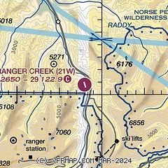
| Sectional chart |
|---|
|
| Airport distance calculator |
|---|
|
|
| Sunrise and sunset |
|---|
|
Times for 01-Feb-2026
| | Local
(UTC-8) | | Zulu
(UTC) |
|---|
| Morning civil twilight | | 06:59 | | 14:59 |
| Sunrise | | 07:32 | | 15:32 |
| Sunset | | 17:08 | | 01:08 |
| Evening civil twilight | | 17:40 | | 01:40 |
|
| Current date and time |
|---|
| Zulu (UTC) | 02-Feb-2026 03:17:06 |
|---|
| Local (UTC-8) | 01-Feb-2026 19:17:06 |
|---|
|
| METAR |
|---|
KSMP
18nm NE | 020256Z AUTO VRB05KT 3SM RA BR BKN005 OVC009 02/02 A3015 RMK AO2 SLP844 6//// T00170017 50011 PNO $
|
KPLU
31nm W | 020255Z AUTO 00000KT 10SM BKN035 BKN044 OVC049 09/08 A3022 RMK AO2
|
|
| TAF |
|---|
KTCM
39nm W | 012100Z 0121/0303 16010G15KT 8000 -SHRA SCT025 OVC050 640509 QNH3003INS BECMG 0122/0123 20010G15KT 9999 VCSH BKN020 610509 QNH3004INS BECMG 0201/0202 18010G15KT 9000 -SHRA BKN030 QNH3009INS BECMG 0205/0206 19010KT 9999 NSW BKN015 QNH3020INS BECMG 0215/0216 17012G18KT 8000 -SHRA BKN025 OVC040 640509 QNH3028INS TX12/0123Z TN08/0212Z
|
KSEA
41nm NW | 012057Z 0121/0224 19010G20KT P6SM VCSH FEW015 BKN030 FM012200 19010KT P6SM VCSH SCT025 OVC035 FM020300 19008KT P6SM OVC050 FM020600 18008KT 3SM BR SCT001 OVC050 FM021200 18006KT 3SM BR BKN003 OVC030 FM021700 14007KT 3SM BR SCT005 OVC020 PROB30 0217/0218 -SHRA
|
KBFI
45nm NW | 012054Z 0121/0218 17007KT P6SM VCSH FEW015 SCT030 BKN045 FM020300 17007KT P6SM OVC050 FM020600 16006KT 3SM BR SCT001 OVC050 FM021200 15005KT 5SM BR BKN005 FM021700 13004KT 4SM BR OVC030 PROB30 0217/0218 -SHRA
|
|
| NOTAMs |
|---|
NOTAMs are issued by the DoD/FAA and will open in a separate window not controlled by AirNav.
|
|

