FAA INFORMATION EFFECTIVE 16 APRIL 2026
Location
| FAA Identifier: | 2O7 |
| Lat/Long: | 36-48-58.9406N 118-12-17.7572W
36-48.982343N 118-12.295953W
36.8163724,-118.2049326
(estimated) |
| Elevation: | 3908.2 ft. / 1191 m (estimated) |
| Variation: | 15E (1985) |
| From city: | 1 mile N of INDEPENDENCE, CA |
| Time zone: | UTC -7 (UTC -8 during Standard Time) |
| Zip code: | 93526 |
Airport Operations
| Airport use: | Open to the public |
| Activation date: | 04/1940 |
| Control tower: | no |
| ARTCC: | LOS ANGELES CENTER |
| FSS: | RIVERSIDE FLIGHT SERVICE STATION |
| NOTAMs facility: | RAL (NOTAM-D service available) |
| Attendance: | UNATNDD |
| Pattern altitude: | 4708.2 ft. MSL |
| Wind indicator: | lighted |
| Segmented circle: | yes
TFC PAT INDICATORS FOR RWY 14/32 ONLY. |
| Lights: | ACTVT MIRL RY 14/32 - CTAF. |
Airport Communications
| CTAF: | 122.9 |
| WX AWOS-3 at O26 (16 nm SE): | 118.25 (760-876-4014) |
Nearby radio navigation aids
| VOR radial/distance | | VOR name | | Freq | | Var |
|---|
| BIHr152/34.5 | | BISHOP VOR/DME | | 113.35 | | 15E |
Airport Services
| Parking: | tiedowns |
| Airframe service: | NONE |
| Powerplant service: | NONE |
| Bottled oxygen: | NONE |
| Bulk oxygen: | NONE |
Runway Information
Runway 14/32
| Dimensions: | 3533 x 60 ft. / 1077 x 18 m |
| Surface: | asphalt, in fair condition
EXTSV LRG CRACKS ON THE NORTH END OF THE RWY. |
| Weight bearing capacity: | |
| Runway edge lights: | medium intensity |
| RUNWAY 14 | | RUNWAY 32 |
| Latitude: | 36-49.233667N | | 36-48.696833N |
| Longitude: | 118-12.428833W | | 118-12.148333W |
| Elevation: | 3894.4 ft. | | 3893.4 ft. |
| Traffic pattern: | left | | right |
| Runway heading: | 142 magnetic, 157 true | | 322 magnetic, 337 true |
| Markings: | basic, in good condition | | basic, in good condition |
| Runway end identifier lights: | no | | no |
| Touchdown point: | yes, no lights | | yes, no lights |
| Obstructions: | 6 ft. fence, 325 ft. from runway, 20:1 slope to clear | | 43 ft. trees, 900 ft. from runway, 110 ft. right of centerline, 16:1 slope to clear |
Runway 5/23
| Dimensions: | 1498 x 30 ft. / 457 x 9 m |
| Surface: | dirt/L
SFC UNEVEN, ROUGH, UNDULATING WITH EXTSV BRUSH. UNSAFE FOR ACFT USE. |
| Runway edge markings: | & RY 23 MARKED WITH AN R ON EACH END; NO NUMBERS OR CNTRLN MARKINGS; MARKINGS FADED. |
| Operational restrictions: | RESTRICTED CAN BE USED ONLY DURING EXTREME CROSSWIND CONDS. |
| RUNWAY 5 | | RUNWAY 23 |
| Latitude: | 36-48.977000N | | 36-49.068333N |
| Longitude: | 118-12.456000W | | 118-12.170667W |
| Elevation: | 3908.2 ft. | | 3879.6 ft. |
| Traffic pattern: | left | | left |
| Runway heading: | 053 magnetic, 068 true | | 233 magnetic, 248 true |
| Markings: | NSTD, in poor condition | | NSTD, in poor condition |
| Runway end identifier lights: | no | | no |
| Touchdown point: | yes, no lights | | yes, no lights |
| Obstructions: | 15 ft. road, 210 ft. from runway, 14:1 slope to clear | | 6 ft. fence, 150 ft. from runway, 140 ft. right of centerline, 25:1 slope to clear |
Airport Ownership and Management from official FAA records
| Ownership: | Publicly-owned |
| Owner: | CITY OF LOS ANGELES
200 NORTH SPRING STREET
LOS ANGELES, CA 90012
LEASED & MAINTAINED BY INYO COUNTY. |
| Manager: | ASHLEY HELMS
703 AIRPORT ROAD
BISHOP, CA 93514
Phone 760-872-2971
DIRECTOR OF PUBLIC WORKS INYO COUNTY. |
Additional Remarks
| - | FOR CD CTC JOSHUA APCH AT 661-277-3843. |
| - | RWY 5/23 UNDULATING UNEVEN DIRT SFC. BRUSH IN SPORADIC LOCATIONS ON RWY. |
| - | RWY 5/23 CLSD FOR PUBLIC USE. |
| - | RWY 5/23 UNSAFE FOR ACFT. |
Instrument Procedures
There are no published instrument procedures at 2O7.
Some nearby airports with instrument procedures:
KBIH - Bishop Airport (34 nm N)
KMMH - Mammoth Yosemite Airport (57 nm NW)
O32 - Reedley Municipal Airport (61 nm W)
KPTV - Porterville Municipal Airport (63 nm SW)
KVIS - Visalia Municipal Airport (65 nm SW)
|
|

Road maps at:
MapQuest
Bing
Google
| Aerial photo |
|---|
WARNING: Photo may not be current or correct
 Photo courtesy of Mark Robinson at eatsleepfly.com
Photo taken 08-Mar-2014
looking west.
Photo courtesy of Mark Robinson at eatsleepfly.com
Photo taken 08-Mar-2014
looking west.
Do you have a better or more recent aerial photo of Independence Airport that you would like to share? If so, please send us your photo.
|
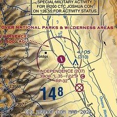
| Sectional chart |
|---|
|
| Airport distance calculator |
|---|
|
|
| Sunrise and sunset |
|---|
|
Times for 21-Apr-2026
| | Local
(UTC-7) | | Zulu
(UTC) |
|---|
| Morning civil twilight | | 05:45 | | 12:45 |
| Sunrise | | 06:12 | | 13:12 |
| Sunset | | 19:31 | | 02:31 |
| Evening civil twilight | | 19:58 | | 02:58 |
|
| Current date and time |
|---|
| Zulu (UTC) | 22-Apr-2026 00:50:41 |
|---|
| Local (UTC-7) | 21-Apr-2026 17:50:41 |
|---|
|
| METAR |
|---|
KO26
16nm SE | 220035Z AUTO 18015G26KT 10SM CLR 14/M03 A2988 RMK A01
|
|
| TAF |
|---|
KBIH
34nm N | 211720Z 2118/2218 17025G35KT P6SM SCT120 FM212300 22018G28KT P6SM FEW120 FM220300 17012G21KT P6SM VCSH SCT100 FM220800 01010KT P6SM FEW200
|
|
| NOTAMs |
|---|
NOTAMs are issued by the DoD/FAA and will open in a separate window not controlled by AirNav.
|
|

