FAA INFORMATION EFFECTIVE 09 JULY 2026
Location
| FAA Identifier: | O26 |
| Lat/Long: | 36-35-19.3000N 118-02-57.8000W
36-35.321667N 118-02.963333W
36.5886944,-118.0493889
(estimated) |
| Elevation: | 3709.8 ft. / 1130.7 m (surveyed) |
| Variation: | 15E (1985) |
| From city: | 1 mile SE of LONE PINE, CA |
| Time zone: | UTC -7 (UTC -8 during Standard Time) |
| Zip code: | 93545 |
Airport Operations
| Airport use: | Open to the public |
| Activation date: | 06/1942 |
| Control tower: | no |
| ARTCC: | LOS ANGELES CENTER |
| FSS: | RIVERSIDE FLIGHT SERVICE STATION |
| NOTAMs facility: | RAL (NOTAM-D service available) |
| Attendance: | IREG |
| Pattern altitude: | 4509.8 ft. MSL |
| Wind indicator: | lighted |
| Segmented circle: | yes |
| Lights: | ACTVT MIRL RY 16/34 - CTAF. |
| Beacon: | white-green (lighted land airport)
ACTVT BCN - CTAF. |
Airport Communications
| CTAF/UNICOM: | 122.8 |
| WX AWOS-3: | 118.25 (760-876-4014) |
- COMMUNICATIONS (N) PRVDD BY RIVERSIDE RADIO ON FREQ 122.6 (BISHOP RCO).
- COMMUNICATIONS (S) PRVDD BY RIVERSIDE RADIO ON FREQ 122.4 (RAND MOUNTAIN RCO).
Airport Services
| Fuel available: | 100LL JET-A
A:FUEL JET A LTD; MUST MAKE PRIOR ARNGMTS WITH FUEL PRVDR 760-872-2971.
100LL:FUEL 100LL AVBL 24 HRS BY CREDIT CARD. |
| Parking: | tiedowns |
Runway Information
Runway 16/34
| Dimensions: | 3991 x 60 ft. / 1216 x 18 m |
| Surface: | asphalt, in excellent condition |
| Weight bearing capacity: | |
| Runway edge lights: | medium intensity |
| RUNWAY 16 | | RUNWAY 34 |
| Latitude: | 36-35.622583N | | 36-34.965417N |
| Longitude: | 118-02.792333W | | 118-02.763507W |
| Elevation: | 3683.7 ft. | | 3678.6 ft. |
| Traffic pattern: | left | | right |
| Runway heading: | 162 magnetic, 177 true | | 342 magnetic, 357 true |
| Markings: | basic, in good condition | | basic, in good condition |
| Runway end identifier lights: | no | | no |
| Touchdown point: | yes, no lights | | yes, no lights |
| Obstructions: | 40 ft. tree, 1300 ft. from runway, 100 ft. right of centerline, 27:1 slope to clear | | 4 ft. fence, 315 ft. from runway, 28:1 slope to clear |
Helipad H1
| Dimensions: | 30 x 30 ft. / 9 x 9 m |
| Surface: | asphalt, in fair condition |
| Latitude: | 36-35.412833N | | |
| Longitude: | 118-03.347500W | | |
| Elevation: | 3701.0 ft. | | |
| Traffic pattern: | left | | left |
Runway 13/31
| Dimensions: | 2391 x 90 ft. / 729 x 27 m |
| Surface: | dirt, in fair condition |
| Runway edge markings: | 13G/31G NO NRS; THRS & DSPLCD THR RY 13G MKD WITH TIRES PAINTED WHITE; WHITE R'S BOTH ENDS OF RY LEFT SIDE. |
| RUNWAY 13 | | RUNWAY 31 |
| Latitude: | 36-35.528690N | | 36-35.211327N |
| Longitude: | 118-03.417605W | | 118-03.128255W |
| Elevation: | 3709.8 ft. | | 3691.4 ft. |
| Traffic pattern: | right | | left |
| Runway heading: | 129 magnetic, 144 true | | 308 magnetic, 323 true |
| Displaced threshold: | 530 ft. | | no |
| Touchdown point: | yes, no lights | | yes, no lights |
| Obstructions: | 40 ft. trees, 85 ft. from runway, 205 ft. right of centerline, 2:1 slope to clear
APCH RATIO 20:1 TO DSPLCD THLD. THLD ACTUALLY DSPLCD 625 FEET. | | 3 ft. fence, 100 ft. from runway, 50 ft. left of centerline, 33:1 slope to clear |
Airport Ownership and Management from official FAA records
| Ownership: | Publicly-owned |
| Owner: | CITY OF LOS ANGELES
200 NORTH SPRING STREET
LOS ANGELES, CA 90012
Phone 213-485-5617
LEASED & MNTND BY INYO CO PUBLIC WORKS, 760-872-2971 |
| Manager: | ASHLEY HELMS
703 AIRPORT ROAD
BISHOP, CA 93514
Phone 760-872-2971
168 N EDWARDS ST, INDEPENDENCE, CA |
Additional Remarks
| - | HANG GLDR AND SKYDIVING ACT IN VICINTY OF ARPT. |
| - | RY 13/31 RSTD TO GLIDERS ONLY EXCEPT PPR - CTAF. |
| - | HELICOPTER TFC APCH ARPT FM EAST ALONG TWY TO HELIPAD. |
| - | PILOTS BE ALERT TO PSBL WIND SHEAR OVER TREES WHILE ON APCH RY 16 WITH SE WINDS 15 KTS OR GTR. |
| - | TWR LCTD 2700 FT NW RY 16 APCH END, (136 AGL) 3717 MSL, UNLGTD. |
| - | FOR CD CTC JOSHUA APCH AT 661-277-3843. |
Instrument Procedures
There are no published instrument procedures at O26.
Some nearby airports with instrument procedures:
KBIH - Bishop Airport (49 nm N)
KIYK - Inyokern Airport (57 nm S)
KNID - China Lake Naval Air Weapons Station (Armitage Field) (57 nm S)
KPTV - Porterville Municipal Airport (59 nm SW)
KVIS - Visalia Municipal Airport (67 nm W)
|
|

Road maps at:
MapQuest
Bing
Google
| Aerial photo |
|---|
WARNING: Photo may not be current or correct

Do you have a better or more recent aerial photo of Lone Pine/Death Valley Airport that you would like to share? If so, please send us your photo.
|
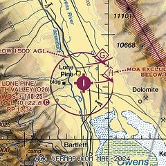
| Sectional chart |
|---|
|
| Airport distance calculator |
|---|
|
|
| Sunrise and sunset |
|---|
|
Times for 19-Jul-2026
| | Local
(UTC-7) | | Zulu
(UTC) |
|---|
| Morning civil twilight | | 05:20 | | 12:20 |
| Sunrise | | 05:49 | | 12:49 |
| Sunset | | 20:08 | | 03:08 |
| Evening civil twilight | | 20:37 | | 03:37 |
|
| Current date and time |
|---|
| Zulu (UTC) | 19-Jul-2026 15:19:27 |
|---|
| Local (UTC-7) | 19-Jul-2026 08:19:27 |
|---|
|
| METAR |
|---|
| KO26 | 191455Z AUTO 00000KT 10SM CLR 26/10 A3011 RMK A01
|
|
| TAF |
|---|
KBIH
49nm N | 191120Z 1912/2012 VRB06KT P6SM SCT120 FM192000 16012G20KT P6SM SCT120 FM200500 33007KT P6SM FEW100 SCT120
|
|
| NOTAMs |
|---|
NOTAMs are issued by the DoD/FAA and will open in a separate window not controlled by AirNav.
|
|

