FAA INFORMATION EFFECTIVE 30 OCTOBER 2025
Location
| FAA Identifier: | 30F |
| Lat/Long: | 33-07-53.0000N 097-00-51.1000W
33-07.883333N 097-00.851667W
33.1313889,-97.0141944
(estimated) |
| Elevation: | 535 ft. / 163 m (estimated) |
| Variation: | 07E (1985) |
| From city: | 1 mile NE of LAKE DALLAS, TX |
| Time zone: | UTC -5 (UTC -6 during Standard Time) |
| Zip code: | 75065 |
Airport Operations
| Airport use: | Open to the public |
| Activation date: | 03/1959 |
| Control tower: | no |
| ARTCC: | FORT WORTH CENTER |
| FSS: | FORT WORTH FLIGHT SERVICE STATION |
| NOTAMs facility: | FTW (NOTAM-D service available) |
| Attendance: | UNATNDD |
| Wind indicator: | yes |
| Segmented circle: | no |
Airport Communications
| CTAF: | 122.9 |
| WX ASOS at DTO (10 nm NW): | 119.325 (940-383-8457) |
| WX AWOS-3PT at ADS (13 nm SE): | PHONE 972-386-4855 |
| WX ASOS at DFW (14 nm S): | PHONE 214-600-7784 |
| WX ASOS at AFW (18 nm SW): | PHONE 817-491-6188 |
| WX ASOS at DAL (19 nm SE): | PHONE 214-353-1551 |
Nearby radio navigation aids
| VOR radial/distance | | VOR name | | Freq | | Var |
|---|
| CVEr333/15.5 | | COWBOY VOR/DME | | 116.20 | | 06E |
| TTTr359/15.8 | | MAVERICK VOR/DME | | 113.10 | | 06E |
| FUZr024/16.7 | | RANGER VORTAC | | 115.70 | | 06E |
| NDB name | | Hdg/Dist | | Freq | | Var | | ID |
|---|
| PINCK | | 131/12.9 | | 257 | | 04E | | DT | -.. - |
Airport Services
| Parking: | tiedowns |
| Bottled oxygen: | NONE |
| Bulk oxygen: | NONE |
Runway Information
Runway 18R/36L
| Dimensions: | 2815 x 30 ft. / 858 x 9 m |
| Surface: | asphalt, in poor condition
RWY PAVEMENT UNEVEN WITH LOOSE STONES, VEGETATION, & POT HOLES. |
| RUNWAY 18R | | RUNWAY 36L |
| Traffic pattern: | left | | left |
| Obstructions: | 25 ft. trees, 201 ft. from runway, 85 ft. right of centerline | | 22 ft. pole, 326 ft. from runway, 135 ft. left of centerline, 5:1 slope to clear |
Runway 18L/36R
| Dimensions: | 2600 x 75 ft. / 792 x 23 m |
| Surface: | turf, in fair condition |
| RUNWAY 18L | | RUNWAY 36R |
| Latitude: | 33-08.096678N | | 33-07.668668N |
| Longitude: | 097-00.836512W | | 097-00.868162W |
| Elevation: | 534.0 ft. | | 531.0 ft. |
| Traffic pattern: | left | | left |
| Runway heading: | 177 magnetic, 184 true | | 357 magnetic, 004 true |
| Obstructions: | 40 ft. trees, 400 ft. from runway, 140 ft. right of centerline, 10:1 slope to clear
20 FT TREES 60 FT DSTC, ACRS APCH. | | 22 ft. pole, 326 ft. from runway, 25 ft. left of centerline, 14:1 slope to clear
15 FT RD 168 FT DSTC ACROSS APCH. |
Airport Ownership and Management from official FAA records
| Ownership: | Publicly-owned |
| Owner: | U S GOVT & SQUIER FAMILY
PO BOX 1026
LAKE DALLAS, TX 75065
Phone 214-850-8180
ARPT PROPERTY SOUTH FM S-TWY LEASED FROM U.S. GOVT-CORPS OF ENGINEERS BY LAKE DALLAS BOAT WORKS & LAKEVIEW AIRPORT; BLDG AREA & RY NORTH OF S-TWY OWNED BY LAKEVIEW ARPT. |
| Manager: | RANDY SQUIER
PO BOX 356
LAKE DALLAS, TX 75065
Phone 214-850-8180 |
Additional Remarks
| - | NO TGL PERMITTED. |
| - | RWY 18R/36L BOATS & TRAILERS PARKED ALONG WEST EDGE OF RWY. |
| - | RWY 18R/36L DEFINED BY MOWING. UNA TO DTRM LCTN OF RWY, NOT INSPD. |
| - | ARPT CLSD TO TSNT STUDENTS. |
| - | BIRDS ON AND INVOF ARPT. |
| - | POWERED PARACHUTES AND BALLOONS PROHIBITED. |
| - | RWY 18L/36R LAKE 350 FT FM NORTH END OF RWY, 170 FT FM SOUTH END. PORTIONS OF RWY MAY BE UNDER WATER DURING HEAVY RAINS. |
| - | GATE LOCKED 24 HRS. |
| - | FOR CD CTC REGIONAL APCH AT 972-615-2799. |
| - | RWY 36 30-50 FT TREES, 65 FT R, PARALLEL TO RWY. |
Instrument Procedures
There are no published instrument procedures at 30F.
Some nearby airports with instrument procedures:
KDTO - Denton Enterprise Airport (10 nm NW)
KADS - Addison Airport (13 nm SE)
KDFW - Dallas-Fort Worth International Airport (14 nm S)
KAFW - Perot Field/Fort Worth Alliance Airport (18 nm SW)
KDAL - Dallas Love Field Airport (19 nm SE)
|
|

Road maps at:
MapQuest
Bing
Google
| Aerial photo |
|---|
WARNING: Photo may not be current or correct
 Photo by Mike Mee
Taken in the Summer of 2017
looking south.
Photo by Mike Mee
Taken in the Summer of 2017
looking south.
Do you have a better or more recent aerial photo of Lakeview Airport that you would like to share? If so, please send us your photo.
|
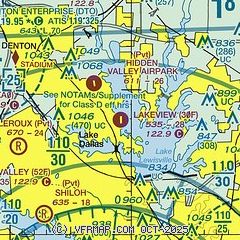
| Sectional chart |
|---|
|
| Airport distance calculator |
|---|
|
|
| Sunrise and sunset |
|---|
|
Times for 31-Oct-2025
| | Local
(UTC-5) | | Zulu
(UTC) |
|---|
| Morning civil twilight | | 07:21 | | 12:21 |
| Sunrise | | 07:47 | | 12:47 |
| Sunset | | 18:37 | | 23:37 |
| Evening civil twilight | | 19:02 | | 00:02 |
|
| Current date and time |
|---|
| Zulu (UTC) | 31-Oct-2025 20:46:35 |
|---|
| Local (UTC-5) | 31-Oct-2025 15:46:35 |
|---|
|
| METAR |
|---|
KDTO
10nm NW | 311953Z VRB04KT 10SM CLR 21/M01 A3006 RMK AO2 SLP177 T02111011
|
KDFW
14nm S | 311953Z 10SM FEW250 22/02 A3004 RMK AO2 SLP169 T02170017
|
KADS
14nm SE | 311947Z 15006KT 10SM SKC 21/01 A3007
|
KAFW
18nm SW | 311953Z 15007KT 10SM SCT200 22/01 A3006 RMK AO2 SLP176 T02170011
|
KDAL
19nm SE | 311953Z VRB03KT 10SM FEW250 21/01 A3006 RMK AO2 SLP176 T02110011
|
|
| TAF |
|---|
KDFW
14nm S | 311730Z 3118/0124 15006KT P6SM FEW250 FM010900 10007KT P6SM OVC120 FM011800 02008KT P6SM OVC080
|
KAFW
18nm SW | 311730Z 3118/0118 15006KT P6SM FEW250 FM010900 10007KT P6SM OVC120
|
KDAL
19nm SE | 311730Z 3118/0118 15006KT P6SM FEW250 FM010900 10007KT P6SM OVC120
|
|
| NOTAMs |
|---|
NOTAMs are issued by the DoD/FAA and will open in a separate window not controlled by AirNav.
|
|


