FAA INFORMATION EFFECTIVE 11 JUNE 2026
Location
| FAA Identifier: | 33S |
| Lat/Long: | 47-07-24.4300N 118-23-21.5800W
47-07.407167N 118-23.359667W
47.1234528,-118.3893278
(estimated) |
| Elevation: | 1801 ft. / 548.9 m (surveyed) |
| Variation: | 19E (1985) |
| From city: | 1 mile W of RITZVILLE, WA |
| Time zone: | UTC -7 (UTC -8 during Standard Time) |
| Zip code: | 99169 |
Airport Operations
| Airport use: | Open to the public |
| Activation date: | 10/1945 |
| Control tower: | no |
| ARTCC: | SEATTLE CENTER |
| FSS: | SEATTLE FLIGHT SERVICE STATION |
| NOTAMs facility: | SEA (NOTAM-D service available) |
| Attendance: | UNATNDD |
| Wind indicator: | lighted |
| Segmented circle: | no |
| Lights: | ACTVT MIRL RY 01/19 AND PAPI RYS 01 & 19 - CTAF. |
| Beacon: | white-green (lighted land airport)
Operates sunset to sunrise. |
Airport Communications
Nearby radio navigation aids
| VOR radial/distance | | VOR name | | Freq | | Var |
|---|
| MWHr080/38.2 | | MOSES LAKE VOR/DME | | 115.00 | | 18E |
Airport Services
| Parking: | tiedowns |
| Airframe service: | NONE |
| Powerplant service: | NONE |
| Bottled oxygen: | NONE |
| Bulk oxygen: | NONE |
Runway Information
Runway 1/19
| Dimensions: | 3433 x 40 ft. / 1046 x 12 m |
| Surface: | asphalt, in good condition |
| Weight bearing capacity: | |
| Runway edge lights: | medium intensity |
| Runway edge markings: | MRKGS ARE FADED. |
| RUNWAY 1 | | RUNWAY 19 |
| Latitude: | 47-07.157500N | | 47-07.657000N |
| Longitude: | 118-23.552833W | | 118-23.166500W |
| Elevation: | 1783.0 ft. | | 1801.0 ft. |
| Traffic pattern: | left | | left |
| Runway heading: | 009 magnetic, 028 true | | 189 magnetic, 208 true |
| Displaced threshold: | no | | 820 ft. |
| Declared distances: | TORA:2614 TODA:2614 ASDA:3433 LDA:3433 | | TORA:3433 TODA:3433 ASDA:3433 LDA:2614 |
| Markings: | basic, in poor condition | | basic, in poor condition |
| Visual slope indicator: | 2-light PAPI on left (4.00 degrees glide path) | | 2-light PAPI on right (3.50 degrees glide path) |
| Touchdown point: | yes, no lights | | yes, no lights |
| Obstructions: | 27 ft. pline, 1282 ft. from runway, 69 ft. right of centerline, 39:1 slope to clear | | 48 ft. tree, 540 ft. from runway, 32 ft. right of centerline, 7:1 slope to clear
HOUSES, ROAD, SIGNS, AND TREES FM 0-200 FT OF THLD. 60 FT TREE 170 FT FM THLD, 70 FT RIGHT. |
Airport Ownership and Management from official FAA records
| Ownership: | Publicly-owned |
| Owner: | CITY OF RITZVILLE
216 E. MAIN
RITZVILLE, WA 99169-1417
Phone 509-659-1930 |
| Manager: | DAVE BREAZEALE
216 E. MAIN
RITZVILLE, WA 99169-1417
Phone 509-659-1930 |
Additional Remarks
| - | ARPT CLSD WHEN SNOW/ICE ON RY. |
| - | FOR CD CTC GRANT COUNTY APCH AT 509-762-2842, WHEN APCH CLSD CTC SEATTLE ARTCC AT 253-351-3694. |
Instrument Procedures
There are no published instrument procedures at 33S.
Some nearby airports with instrument procedures:
KMWH - Grant County International Airport (38 nm W)
2S8 - Wilbur Airport (40 nm N)
KSKA - Fairchild Air Force Base (42 nm NE)
KGEG - Spokane International Airport (46 nm NE)
KEPH - Ephrata Municipal Airport (47 nm W)
|
|

Road maps at:
MapQuest
Bing
Google
| Aerial photo |
|---|
WARNING: Photo may not be current or correct
 Photo by David Wyatt
Photo taken 22-Jun-2007
Photo by David Wyatt
Photo taken 22-Jun-2007
Do you have a better or more recent aerial photo of Pru Field Airport that you would like to share? If so, please send us your photo.
|
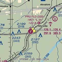
| Sectional chart |
|---|
|
| Airport distance calculator |
|---|
|
|
| Sunrise and sunset |
|---|
|
Times for 24-Jun-2026
| | Local
(UTC-7) | | Zulu
(UTC) |
|---|
| Morning civil twilight | | 04:20 | | 11:20 |
| Sunrise | | 05:00 | | 12:00 |
| Sunset | | 20:52 | | 03:52 |
| Evening civil twilight | | 21:32 | | 04:32 |
|
| Current date and time |
|---|
| Zulu (UTC) | 24-Jun-2026 17:38:44 |
|---|
| Local (UTC-7) | 24-Jun-2026 10:38:44 |
|---|
|
| METAR |
|---|
KMWH
38nm W | 241652Z 12003KT 10SM CLR 27/06 A2998 RMK AO2 SLP143 T02670056
|
KSKA
42nm NE | 241555Z 04005KT 10SM CLR 23/07 A3003 RMK AO2A SLP149 T02330065 $
|
KGEG
46nm NE | 241653Z 03004KT 10SM FEW022 BKN260 24/07 A3002 RMK AO2 SLP148 T02390067
|
KEPH
47nm W | 241653Z AUTO VRB04KT 10SM CLR 28/03 A2997 RMK AO2 SLP137 T02830033
|
|
| TAF |
|---|
KMWH
38nm W | 241139Z 2412/2512 VRB04KT P6SM SCT250 FM250000 27011G20KT P6SM SCT110 FM250200 31015G21KT P6SM SCT110 FM250400 32008KT P6SM SCT110 FM251100 30005KT P6SM FEW210
|
KSKA
42nm NE | 241100Z 2411/2517 01006KT 9999 SCT200 QNH3000INS BECMG 2418/2419 04009KT 9999 SCT150 BKN220 QNH2987INS BECMG 2503/2504 34006KT 9999 VCSH BKN150 QNH2984INS BECMG 2511/2512 VRB06KT 9999 NSW BKN200 QNH2983INS TX30/2422Z TN14/2412Z
|
KGEG
46nm NE | 241139Z 2412/2512 VRB04KT P6SM FEW200 FM241800 05005KT P6SM BKN240 FM242300 VRB06KT P6SM BKN090 FM250400 31010G18KT P6SM BKN100 FM250600 02007KT P6SM BKN110
|
|
| NOTAMs |
|---|
NOTAMs are issued by the DoD/FAA and will open in a separate window not controlled by AirNav.
|
|

