FAA INFORMATION EFFECTIVE 19 MARCH 2026
Location
| FAA Identifier: | 40C |
| Lat/Long: | 42-12-02.5982N 086-14-57.7160W
42-12.043303N 086-14.961933W
42.2007217,-86.2493656
(estimated) |
| Elevation: | 656 ft. / 200 m (estimated) |
| Variation: | 03W (1985) |
| From city: | 1 mile NE of WATERVLIET, MI |
| Time zone: | UTC -4 (UTC -5 during Standard Time) |
| Zip code: | 49098 |
Airport Operations
| Airport use: | Open to the public |
| Activation date: | 12/1950 |
| Control tower: | no |
| ARTCC: | CHICAGO CENTER |
| FSS: | LANSING FLIGHT SERVICE STATION |
| NOTAMs facility: | LAN (NOTAM-D service available) |
| Attendance: | UNATNDD |
| Wind indicator: | yes |
| Segmented circle: | yes |
| Lights: | ACTVT MIRL RWY 02/20 - CTAF. |
Airport Communications
| CTAF: | 122.9 |
| WX ASOS at BEH (9 nm SW): | 121.55 (269-925-9008) |
| WX AWOS-3P at LWA (9 nm N): | 118.025 (269-637-7016) |
Nearby radio navigation aids
| VOR radial/distance | | VOR name | | Freq | | Var |
|---|
| PMMr202/17.2 | | PULLMAN VOR/DME | | 112.10 | | 00E |
| GIJr007/26.1 | | GIPPER VORTAC | | 115.40 | | 00E |
Airport Services
| Parking: | tiedowns |
| Airframe service: | NONE |
| Powerplant service: | NONE |
| Bottled oxygen: | NONE |
| Bulk oxygen: | NONE |
Runway Information
Runway 2/20
| Dimensions: | 2600 x 200 ft. / 792 x 61 m |
| Surface: | turf, in good condition
SOFT WHEN WET & DURG SPRING DUE TO POOR DRAINAGE. |
| Runway edge lights: | medium intensity |
| Runway edge markings: | RWY & DTHR MKD WITH 3 FT YELLOW CONES. |
| RUNWAY 2 | | RUNWAY 20 |
| Latitude: | 42-11.876833N | | 42-12.292167N |
| Longitude: | 086-15.002833W | | 086-14.863500W |
| Elevation: | 650.0 ft. | | 651.0 ft. |
| Traffic pattern: | left | | left |
| Runway heading: | 017 magnetic, 014 true | | 197 magnetic, 194 true |
| Displaced threshold: | 600 ft. | | 800 ft. |
| Obstructions: | 70 ft. trees, 50 ft. from runway, 125 ft. right of centerline
APCH RATIO 9:1 TO DTHR OVR 70 FT TREES, 650 FT DIST, 125 FT R. | | 70 ft. trees, 320 ft. from runway, 125 ft. right of centerline, 4:1 slope to clear
APCH RATIO 4:1 TO DTHR OVR 98 FT TREES, 392 FT DIST, 165 FT L. |
Runway 7/25
| Dimensions: | 1540 x 200 ft. / 469 x 61 m |
| Surface: | turf, in fair condition
SOFT WHEN WET & DURG SPRING DUE TO POOR DRAINAGE. |
| Runway edge markings: | DEFINED BY MOWING. |
| Operational restrictions: | UNVERIFIED LDG AREA - CTC AMGR FOR DTLS. |
| RUNWAY 7 | | RUNWAY 25 |
| Latitude: | 42-11.939833N | | 42-12.007667N |
| Longitude: | 086-15.174833W | | 086-14.846167W |
| Elevation: | 656.0 ft. | | 656.0 ft. |
| Traffic pattern: | left | | left |
| Runway heading: | 077 magnetic, 074 true | | 257 magnetic, 254 true |
| Runway end identifier lights: | no | | no |
| Obstructions: | 69 ft. trees, 345 ft. from runway, 125 ft. right of centerline, 5:1 slope to clear | | 60 ft. trees, 120 ft. right of centerline |
Airport Ownership and Management from official FAA records
| Ownership: | Publicly-owned |
| Owner: | WATERVLIET TOWNSHIP
4959 M140 HWY
WATERVLIET, MI 49098-9707
Phone 616-463-5113 |
| Manager: | ROBERT P LOHR
4959 M140 HWY
WATERVLIET, MI 49098-9707
Phone 269-757-1180
ASST AMGR CELL 269-876-1536. |
Additional Remarks
| - | UAS, ULTRALIGHT, & PWRD PRCHT ACT. |
| - | HOSP HLP 1 NM S. |
| - | FOR CD CTC CHICAGO ARTCC AT 630-906-8921. |
Instrument Procedures
There are no published instrument procedures at 40C.
Some nearby airports with instrument procedures:
KBEH - Southwest Michigan Regional Airport (9 nm SW)
KLWA - South Haven Area Regional Airport (9 nm N)
C91 - Dowagiac Municipal Airport (14 nm SE)
C20 - Andrews University Airpark (16 nm S)
3TR - Jerry Tyler Memorial Airport (22 nm S)
|
|

Road maps at:
MapQuest
Bing
Google
| Aerial photo |
|---|
WARNING: Photo may not be current or correct

Do you have a better or more recent aerial photo of Watervliet Municipal Airport that you would like to share? If so, please send us your photo.
|
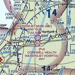
| Sectional chart |
|---|
|
| Airport distance calculator |
|---|
|
|
| Sunrise and sunset |
|---|
|
Times for 05-Apr-2026
| | Local
(UTC-4) | | Zulu
(UTC) |
|---|
| Morning civil twilight | | 06:53 | | 10:53 |
| Sunrise | | 07:22 | | 11:22 |
| Sunset | | 20:14 | | 00:14 |
| Evening civil twilight | | 20:42 | | 00:42 |
|
| Current date and time |
|---|
| Zulu (UTC) | 05-Apr-2026 23:38:17 |
|---|
| Local (UTC-4) | 05-Apr-2026 19:38:17 |
|---|
|
| METAR |
|---|
KBEH
8nm SW | 052253Z AUTO 26006KT 10SM CLR 07/M03 A3016 RMK AO2 SLP217 T00671033
|
KLWA
9nm N | 052315Z AUTO 24007KT 10SM CLR 07/M03 A3015 RMK AO2
|
|
| TAF |
|---|
KSBN
30nm S | 051720Z 0518/0618 30013G25KT P6SM FEW250 FM060100 25009KT P6SM SCT050 FM060900 28009KT 3SM -SHRA SCT015 BKN025 FM061200 30012G22KT P6SM BKN020 FM061600 30012G26KT P6SM BKN040
|
KAZO
31nm E | 052033Z 0521/0618 29013G23KT P6SM OVC035 FM052200 29013G23KT P6SM SCT040 FM060100 27008KT P6SM VCSH BKN035 FM060700 27006KT 6SM -SHRA BKN020 FM061300 30012G20KT P6SM -SHRA BKN020
|
|
| NOTAMs |
|---|
NOTAMs are issued by the DoD/FAA and will open in a separate window not controlled by AirNav.
|
|

