FAA INFORMATION EFFECTIVE 09 JULY 2026
Location
| FAA Identifier: | 40U |
| Lat/Long: | 40-59-11.0200N 109-40-42.6970W
40-59.183667N 109-40.711617W
40.9863944,-109.6785269
(estimated) |
| Elevation: | 6178.7 ft. / 1883 m (estimated) |
| Variation: | 10E (2025) |
| From city: | 2 miles E of MANILA, UT |
| Time zone: | UTC -6 (UTC -7 during Standard Time) |
| Zip code: | 84046 |
Airport Operations
| Airport use: | Open to the public |
| Activation date: | 11/1969 |
| Control tower: | no |
| ARTCC: | SALT LAKE CITY CENTER |
| FSS: | CEDAR CITY FLIGHT SERVICE STATION |
| NOTAMs facility: | CDC (NOTAM-D service available) |
| Attendance: | UNATTND |
| Wind indicator: | yes |
| Segmented circle: | yes |
| Lights: | SS-SR |
| Beacon: | white-green (lighted land airport)
Operates sunset to sunrise. |
Airport Communications
| CTAF/UNICOM: | 122.8 |
| WX AWOS-3PT: | 119.250 (435-784-3123) |
- APCH/DEP SVC PRVDD BY SALT LAKE ARTCC (ZLC) ON FREQS 119.95/377.15 (MYTON RCAG).
Nearby radio navigation aids
| VOR radial/distance | | VOR name | | Freq | | Var |
|---|
| VELr332/37.4 | | VERNAL VOR/DME | | 114.15 | | 15E |
Airport Services
| Parking: | tiedowns |
| Airframe service: | NONE |
| Powerplant service: | NONE |
| Bottled oxygen: | NONE |
| Bulk oxygen: | NONE |
Runway Information
Runway 7/25
| Dimensions: | 5305 x 60 ft. / 1617 x 18 m |
| Surface: | asphalt, in good condition |
| Weight bearing capacity: | |
| Runway edge lights: | medium intensity |
| RUNWAY 7 | | RUNWAY 25 |
| Latitude: | 40-59.179250N | | 40-59.188052N |
| Longitude: | 109-41.287858W | | 109-40.135380W |
| Elevation: | 6178.7 ft. | | 6115.3 ft. |
| Traffic pattern: | left | | left |
| Runway heading: | 079 magnetic, 089 true | | 259 magnetic, 269 true |
| Markings: | basic, in good condition | | basic, in good condition |
| Touchdown point: | yes, no lights | | yes, no lights |
| Obstructions: | 21 ft. hill, 634 ft. from runway, 20:1 slope to clear
CTLG OBSTN EXCEEDS A 45 DEG SLP. | | 25 ft. trees, 201 ft. from runway, 120 ft. right of centerline
4-15 FT TREES, 0-199 FT DSTC, 0-125 FT R. |
Airport Ownership and Management from official FAA records
| Ownership: | Publicly-owned |
| Owner: | DAGGETT COUNTY
95 N. 1ST W, PO BOX 219
MANILA, UT 84046-0219
Phone 435-784-3154 |
| Manager: | KENT BOND
95 NORTH 1ST WEST, PO BOX 219
MANILA, UT 84046-0219
Phone 801-913-5223
COUNTY CLERK/ARPT MGR. |
Additional Remarks
| - | 3 TO 6 FT DITCH PARL TO RWY, 40 FT EACH SIDE OF CNTRLN. |
| - | FOR CD CTC SALT LAKE ARTCC AT 801-320-2568. |
| - | SN PLOWING IREG. CALL FOR FICONS. |
Instrument Procedures
NOTE: All procedures below are presented as PDF files. If you need a reader for these files, you should download the free Adobe Reader.NOT FOR NAVIGATION. Please procure official charts for flight.
FAA instrument procedures published for use from 09 July 2026 at 0901Z to 06 August 2026 at 0900Z.
IAPs - Instrument Approach Procedures |
|---|
| RNAV (GPS) RWY 25 | |
download (242KB) |
| NOTE: Special Alternate Minimums apply | |
download (142KB) |
|
|---|
| WEGEM ONE (OBSTACLE) (RNAV) | |
download (294KB) |
| NOTE: Special Take-Off Minimums/Departure Procedures apply | |
download (387KB) |
Other nearby airports with instrument procedures:
KVEL - Vernal Regional Airport (34 nm S)
KFBR - Fort Bridger Airport (41 nm NW)
74V - Roosevelt Municipal Airport (46 nm S)
KRKS - Southwest Wyoming Regional Airport (46 nm NE)
U69 - Duchesne Municipal Airport (57 nm SW)
|
|

Road maps at:
MapQuest
Bing
Google
| Aerial photo |
|---|
WARNING: Photo may not be current or correct
 Photo courtesy of www.axenty.com
Photo taken 31-Jan-2009
looking west.
Photo courtesy of www.axenty.com
Photo taken 31-Jan-2009
looking west.
Do you have a better or more recent aerial photo of Manila Airport that you would like to share? If so, please send us your photo.
|
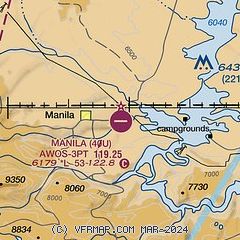
| Sectional chart |
|---|
|
| Airport distance calculator |
|---|
|
|
| Sunrise and sunset |
|---|
|
Times for 22-Jul-2026
| | Local
(UTC-6) | | Zulu
(UTC) |
|---|
| Morning civil twilight | | 05:35 | | 11:35 |
| Sunrise | | 06:06 | | 12:06 |
| Sunset | | 20:44 | | 02:44 |
| Evening civil twilight | | 21:16 | | 03:16 |
|
| Current date and time |
|---|
| Zulu (UTC) | 23-Jul-2026 04:38:26 |
|---|
| Local (UTC-6) | 22-Jul-2026 22:38:26 |
|---|
|
| METAR |
|---|
KVEL
33nm S | 230353Z AUTO 16006KT 10SM BKN100 OVC120 25/13 A3015 RMK AO2 SLP137 T02500133
|
KFBR
41nm NW | 230415Z AUTO 21004KT 10SM OVC080 20/14 A3033 RMK AO2 LTG DSNT E T01950143
|
K74V
46nm S | 230415Z AUTO 04004KT 10SM SCT120 22/19 A3016 RMK AO2
|
KRKS
46nm NE | 230354Z AUTO 26011KT 10SM FEW065 SCT095 BKN110 20/13 A3029 RMK AO2 SLP163 T02000133
|
|
| TAF |
|---|
KVEL
33nm S | 221738Z 2218/2318 21006KT P6SM FEW070 SCT200 FM222100 21007KT P6SM FEW080 BKN150 TEMPO 2221/2301 VRB15G29KT 4SM -TSRA BKN090CB FM230100 17006KT 6SM -SHRA SCT035 BKN050 BKN100 PROB30 2303/2306 4SM TSRA BKN060CB FM230600 04005KT P6SM SCT045 BKN080 PROB30 2306/2308 4SM -SHRA BKN045 FM230800 00000KT P6SM SCT030 BKN080 PROB30 2308/2309 4SM -SHRA BKN030
|
|
| NOTAMs |
|---|
NOTAMs are issued by the DoD/FAA and will open in a separate window not controlled by AirNav.
|
|

