FAA INFORMATION EFFECTIVE 19 FEBRUARY 2026
Location
| FAA Identifier: | 47V |
| Lat/Long: | 40-38-19.5000N 100-28-24.3000W
40-38.325000N 100-28.405000W
40.6387500,-100.4734167
(estimated) |
| Elevation: | 2677.4 ft. / 816.1 m (surveyed) |
| Variation: | 06E (2015) |
| From city: | 2 miles E of CURTIS, NE |
| Time zone: | UTC -6 (UTC -5 during Daylight Saving Time) |
| Zip code: | 69025 |
Airport Operations
| Airport use: | Open to the public |
| Activation date: | 10/1947 |
| Control tower: | no |
| ARTCC: | DENVER CENTER |
| FSS: | COLUMBUS FLIGHT SERVICE STATION |
| NOTAMs facility: | OLU (NOTAM-D service available) |
| Attendance: | UNATNDD |
| Wind indicator: | lighted |
| Segmented circle: | yes |
| Lights: | ACTVT MIRL RY 12/30 - CTAF. |
| Beacon: | white-green (lighted land airport)
Operates sunset to sunrise. |
Airport Communications
- APCH/DEP CTL SVC PRVDD BY DENVER ARTCC (ZDV) ON FREQS 132.7/226.675 (NORTH PLATTE RCAG).
Nearby radio navigation aids
| VOR radial/distance | | VOR name | | Freq | | Var |
|---|
| HCTr051/23.3 | | HAYES CENTER VORTAC | | 117.70 | | 11E |
| OZBr228/(25.5) | | COZAD VOR | | 109.00 | | 09E |
| MCKr004/26.7 | | MC COOK VOR/DME | | 115.30 | | 08E |
| LBFr142/27.6 | | NORTH PLATTE VOR/DME | | 117.40 | | 11E |
Airport Services
| Fuel available: | 100LL
100LL:FOR FUEL AFT HRS & UNATNDD DAYS CALL AMGR (308) 367-7352. |
| Parking: | hangars and tiedowns |
| Bottled oxygen: | NONE |
| Bulk oxygen: | NONE |
Runway Information
Runway 12/30
| Dimensions: | 3402 x 60 ft. / 1037 x 18 m |
| Surface: | concrete, in good condition |
| Weight bearing capacity: | |
| Runway edge lights: | medium intensity |
| RUNWAY 12 | | RUNWAY 30 |
| Latitude: | 40-38.516370N | | 40-38.165512N |
| Longitude: | 100-28.651020W | | 100-28.077873W |
| Elevation: | 2677.2 ft. | | 2661.0 ft. |
| Traffic pattern: | left | | left |
| Runway heading: | 123 magnetic, 129 true | | 303 magnetic, 309 true |
| Markings: | nonprecision, in good condition | | nonprecision, in good condition |
| Touchdown point: | yes, no lights | | yes, no lights |
Runway 17/35
| Dimensions: | 2200 x 120 ft. / 671 x 37 m |
| Surface: | turf, in fair condition |
| Operational restrictions: | RY 17/35 MKD WITH YELLOW CONES. |
| RUNWAY 17 | | RUNWAY 35 |
| Latitude: | 40-38.480065N | | 40-38.118135N |
| Longitude: | 100-28.458607W | | 100-28.478707W |
| Elevation: | 2675.6 ft. | | 2667.9 ft. |
| Traffic pattern: | left | | left |
| Runway heading: | 176 magnetic, 182 true | | 356 magnetic, 002 true |
| Touchdown point: | yes, no lights | | yes, no lights |
Airport Ownership and Management from official FAA records
| Ownership: | Publicly-owned |
| Owner: | CURTIS AIRPORT AUTHORITY
PO BOX 11
CURTIS, NE 69025-0011
Phone (308) 362-7088
RYAN PATE, CHAIRMAN OF AIRPORT AUTHORITY. |
| Manager: | TOM BROWN
PO BOX 131
CURTIS, NE 69025-0131
Phone (308) 367-7352 |
Additional Remarks
| A58-30 | CROPS 5 FT TALL AT THE END OF RWY, 125 FT L AND EXTDG TO 250 FT L. |
| A58-12 | CROPS 5 FT TALL ON BOTH SIDES OF THE RWY, 125 FT L & R AND GOING OUT TO 250 FT L & R FM RWY END. |
| A52-17 | OBSTRUCTION MAY BE CROPS DURING GROWING SEASON. |
| - | FOR CD CTC DENVER ARTCC AT 303-651-4257. |
Instrument Procedures
NOTE: All procedures below are presented as PDF files. If you need a reader for these files, you should download the free Adobe Reader.NOT FOR NAVIGATION. Please procure official charts for flight.
FAA instrument procedures published for use from 19 February 2026 at 0901Z to 19 March 2026 at 0900Z.
IAPs - Instrument Approach Procedures |
|---|
| RNAV (GPS) RWY 12 **CHANGED** | |
download (209KB) |
| RNAV (GPS) RWY 30 **CHANGED** | |
download (195KB) |
| NOTE: Special Take-Off Minimums/Departure Procedures apply | |
download |
Other nearby airports with instrument procedures:
KGTE - Gothenburg Municipal Airport (23 nm NE)
KCSB - Cambridge Municipal Airport (24 nm SE)
KCZD - Cozad Municipal Airport (25 nm NE)
KMCK - Mc Cook Ben Nelson Regional Airport (27 nm S)
KLBF - North Platte Regional Airport/Lee Bird Field (31 nm N)
|
|

Road maps at:
MapQuest
Bing
Google
| Aerial photo |
|---|
WARNING: Photo may not be current or correct

Do you have a better or more recent aerial photo of Curtis Municipal Airport that you would like to share? If so, please send us your photo.
|
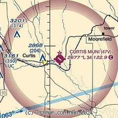
| Sectional chart |
|---|
|
| Airport distance calculator |
|---|
|
|
| Sunrise and sunset |
|---|
|
Times for 10-Mar-2026
| | Local
(UTC-5) | | Zulu
(UTC) |
|---|
| Morning civil twilight | | 07:35 | | 12:35 |
| Sunrise | | 08:03 | | 13:03 |
| Sunset | | 19:42 | | 00:42 |
| Evening civil twilight | | 20:09 | | 01:09 |
|
| Current date and time |
|---|
| Zulu (UTC) | 10-Mar-2026 14:32:05 |
|---|
| Local (UTC-5) | 10-Mar-2026 09:32:05 |
|---|
|
| METAR |
|---|
KCSB
24nm SE | 101415Z AUTO 03012KT 9SM SCT008 SCT013 03/01 A2981 RMK AO2
|
KMCK
27nm S | 101400Z AUTO 01015G19KT 10SM OVC009 01/M01 A2983 RMK AO2 T00111011
|
KLBF
30nm N | 101411Z AUTO 07013KT 10SM SCT007 OVC016 01/M01 A2981 RMK AO2 T00111011 $
|
KLXN
33nm E | 101415Z AUTO 03011KT 10SM CLR 02/M03 A2983 RMK AO2 T00181031
|
KOIN
48nm S | 101415Z AUTO 35017G20KT 10SM OVC010 02/02 A2981 RMK AO2
|
|
| TAF |
|---|
KMCK
27nm S | 101304Z 1013/1112 36015G20KT P6SM OVC010 FM101500 01014KT P6SM SCT010 FM101700 15014KT P6SM SKC FM110000 02010KT P6SM SCT250 FM110300 34020G30KT P6SM BKN200
|
KLBF
30nm N | 101301Z 1013/1112 04011G20KT P6SM OVC005 FM101400 04012G22KT P6SM OVC030 FM101600 05008KT P6SM SCT040 FM102200 03012KT P6SM OVC100 FM110100 01012G24KT P6SM OVC100
|
|
| NOTAMs |
|---|
NOTAMs are issued by the DoD/FAA and will open in a separate window not controlled by AirNav.
|
|

