FAA INFORMATION EFFECTIVE 27 NOVEMBER 2025
Location
| FAA Identifier: | 48I |
| Lat/Long: | 38-41-13.6000N 080-39-07.5000W
38-41.226667N 080-39.125000W
38.6871111,-80.6520833
(estimated) |
| Elevation: | 1275.6 ft. / 389 m (estimated) |
| Variation: | 08W (2015) |
| From city: | 3 miles E of SUTTON, WV |
| Time zone: | UTC -5 (UTC -4 during Daylight Saving Time) |
| Zip code: | 26601 |
Airport Operations
| Airport use: | Open to the public |
| Activation date: | 10/1937 |
| Control tower: | no |
| ARTCC: | CLEVELAND CENTER |
| FSS: | ELKINS FLIGHT SERVICE STATION [703-724-4288] |
| NOTAMs facility: | EKN (NOTAM-D service available) |
| Attendance: | UNATNDD |
| Wind indicator: | lighted |
| Segmented circle: | yes |
| Lights: | ACTVT REIL RWY 02 & 20; PAPI RWY 20; MIRL RWY 02/20 - CTAF. |
| Beacon: | white-green (lighted land airport)
BCN LCTD ON HILL, 1/4 MILE NW OF ARPT. ACTVT BEACON - CTAF. |
Airport Communications
| CTAF: | 122.9 |
| WX AWOS-3PT: | 118.225 (304-765-7805) |
| CLARKSBURG APPROACH: | 121.15 |
| CLARKSBURG DEPARTURE: | 121.15 |
- APCH/DEP SVC PRVDD BY INDIANAPOLIS ARTCC ON FREQS 125.55/317.475 (PARKERSBURG RCAG) WHEN CLARKSBURG APCH CTL CLSD.
Nearby radio navigation aids
| VOR radial/distance | | VOR name | | Freq | | Var |
|---|
| EKNr249/29.2 | | ELKINS VORTAC | | 114.20 | | 07W |
| CKBr212/38.4 | | CLARKSBURG VOR/DME | | 112.60 | | 04W |
| NDB name | | Hdg/Dist | | Freq | | Var | | ID |
|---|
| RANDOLPH COUNTY | | 258/39.1 | | 284 | | 07W | | RQY | .-. --.- -.-- |
Airport Services
| Fuel available: | 100LL JET-A |
| Parking: | hangars and tiedowns |
| Airframe service: | NONE |
| Powerplant service: | NONE |
| Bottled oxygen: | NONE |
| Bulk oxygen: | NONE |
Runway Information
Runway 2/20
| Dimensions: | 3995 x 60 ft. / 1218 x 18 m |
| Surface: | asphalt/aggregate friction seal coat, in good condition |
| Weight bearing capacity: | |
| Runway edge lights: | medium intensity |
| RUNWAY 2 | | RUNWAY 20 |
| Latitude: | 38-40.899600N | | 38-41.551977N |
| Longitude: | 080-39.181317W | | 080-39.068783W |
| Elevation: | 1252.5 ft. | | 1275.6 ft. |
| Traffic pattern: | left | | left |
| Runway heading: | 016 magnetic, 008 true | | 196 magnetic, 188 true |
| Displaced threshold: | 801 ft. | | no |
| Declared distances: | TORA:3995 TODA:3995 ASDA:3995 LDA:3194 | | TORA:3995 TODA:3995 ASDA:3815 LDA:3815 |
| Markings: | basic, in good condition | | nonprecision, in good condition |
| Visual slope indicator: | | | 2-light PAPI on left (4.00 degrees glide path)
UNUSBL BYD 6 DEG LEFT AND BYD 6 DEG RIGHT OF CNTRLN. |
| Runway end identifier lights: | yes | | yes |
| Touchdown point: | yes, no lights | | yes, no lights |
| Obstructions: | 85 ft. trees, 201 ft. from runway, 220 ft. right of centerline
26 FT TREES, 0-199, 216 FT L. | | 113 ft. trees, 844 ft. from runway, 370 ft. right of centerline, 5:1 slope to clear
17 FT HILL, 0-199 FT DSTC, 247 FT R. |
Airport Ownership and Management from official FAA records
| Ownership: | Publicly-owned |
| Owner: | CO CMSN OF BRAXTON
BOX 486
SUTTON, WV 26601
Phone 304-765-2835 |
| Manager: | PATRICK O'MALLEY
106 BIRCH ST
GASAWAY, WV 26624-1102
Phone (304) 542-3311 |
Additional Remarks
| - | 6 FT DITCH CROSSES AER 02 0-116 FT FROM THR. |
| - | GATE ACCESS 1-2-3-4-#. |
| - | FOR CD CTC CLARKSBURG APCH AT 304-842-2011. WHEN APP CLSD, CTC INDIANAPOLIS ARTCC AT 317-247-2411. |
| - | DEER ON AND INVOF ARPT. |
Instrument Procedures
NOTE: All procedures below are presented as PDF files. If you need a reader for these files, you should download the free Adobe Reader.NOT FOR NAVIGATION. Please procure official charts for flight.
FAA instrument procedures published for use from 27 November 2025 at 0901Z to 25 December 2025 at 0900Z.
IAPs - Instrument Approach Procedures |
|---|
| RNAV (GPS) RWY 20 | |
download (211KB) |
| NOTE: Special Take-Off Minimums/Departure Procedures apply | |
download (432KB) |
Other nearby airports with instrument procedures:
W22 - Upshur County Regional Airport (26 nm NE)
KSXL - Summersville Airport (29 nm S)
KUSW - Boggs Field Airport (34 nm W)
KEKN - Elkins-Randolph County Airport-Jennings Randolph Field (39 nm E)
79D - Philippi/Barbour County Regional Airport (40 nm NE)
|
|

Road maps at:
MapQuest
Bing
Google
| Aerial photo |
|---|
WARNING: Photo may not be current or correct
 Photo by George Hall
Photo taken 12-Oct-2008
Photo by George Hall
Photo taken 12-Oct-2008
Do you have a better or more recent aerial photo of Braxton County Airport that you would like to share? If so, please send us your photo.
|
| Sectional chart |
|---|
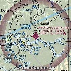
|
| Airport distance calculator |
|---|
|
|
| Sunrise and sunset |
|---|
|
Times for 04-Dec-2025
| | Local
(UTC-5) | | Zulu
(UTC) |
|---|
| Morning civil twilight | | 06:56 | | 11:56 |
| Sunrise | | 07:26 | | 12:26 |
| Sunset | | 17:00 | | 22:00 |
| Evening civil twilight | | 17:30 | | 22:30 |
|
| Current date and time |
|---|
| Zulu (UTC) | 05-Dec-2025 00:46:32 |
|---|
| Local (UTC-5) | 04-Dec-2025 19:46:32 |
|---|
|
| TAF |
|---|
KEKN
39nm E | 041722Z 0418/0518 29008KT P6SM BKN012 FM042100 31005KT P6SM BKN025 FM050700 12004KT 3SM BR BKN020 FM050900 16004KT 2SM -SHSN OVC007 FM051200 VRB03KT 4SM BR OVC010
|
KCKB
42nm NE | 041722Z 0418/0518 29006KT P6SM OVC011 FM042100 31005KT P6SM BKN020 FM050000 VRB04KT P6SM BKN045 FM050800 VRB04KT 6SM BR BKN023
|
KCRW
47nm W | 041722Z 0418/0518 32004KT P6SM OVC013 FM050000 04004KT P6SM BKN020 FM050500 VRB03KT 4SM BR OVC015 FM050700 VRB03KT 2SM -SN BKN006 BKN017 FM051100 VRB03KT 3SM BR OVC009 FM051500 25004KT 6SM BR OVC012
|
|
| NOTAMs |
|---|
NOTAMs are issued by the DoD/FAA and will open in a separate window not controlled by AirNav.
|
|

