FAA INFORMATION EFFECTIVE 11 JUNE 2026
Location
| FAA Identifier: | 4T2 |
| Lat/Long: | 32-58-39.4742N 097-29-32.2572W
32-58.657903N 097-29.537620W
32.9776317,-97.4922937
(estimated) |
| Elevation: | 693 ft. / 211.2 m (surveyed) |
| Variation: | 04E (2015) |
| From city: | 18 miles NW of FORT WORTH, TX |
| Time zone: | UTC -5 (UTC -6 during Standard Time) |
| Zip code: | 76179 |
Airport Operations
| Airport use: | Open to the public |
| Activation date: | 03/1981 |
| Control tower: | no |
| ARTCC: | FORT WORTH CENTER |
| FSS: | FORT WORTH FLIGHT SERVICE STATION |
| NOTAMs facility: | FTW (NOTAM-D service available) |
| Attendance: | UNATNDD |
| Wind indicator: | lighted |
| Segmented circle: | no |
| Lights: | ACTVT LIRL RWY 17/35; TWY LTS - CTAF. |
| Beacon: | white-green (lighted land airport)
Operates sunset to sunrise. |
Airport Communications
| CTAF/UNICOM: | 123.075 |
| LONE STAR APPROACH: | 125.8 |
| LONE STAR DEPARTURE: | 125.8 |
| WX ASOS at AFW (9 nm E): | PHONE 817-491-6188 |
| WX ASOS at FTW (12 nm SE): | PHONE 817-740-3346 |
| WX AWOS-3 at LUD (17 nm N): | 118.225 (940-627-2365) |
| WX ASOS at DTO (20 nm NE): | 119.325 (940-354-2971) |
Nearby radio navigation aids
| VOR radial/distance | | VOR name | | Freq | | Var |
|---|
| FUZr283/16.6 | | RANGER VORTAC | | 115.70 | | 06E |
| TTTr280/23.7 | | MAVERICK VOR/DME | | 113.10 | | 06E |
| MQPr050/29.6 | | MILLSAP VORTAC | | 117.70 | | 09E |
| CVEr274/30.1 | | COWBOY VOR/DME | | 116.20 | | 06E |
| UKWr148/37.3 | | BOWIE VORTAC | | 117.15 | | 06E |
| NDB name | | Hdg/Dist | | Freq | | Var | | ID |
|---|
| MUFIN | | 302/7.8 | | 365 | | 08E | | FT | ..-. - |
Airport Services
Runway Information
Runway 17/35
| Dimensions: | 5943 x 127 ft. / 1811 x 39 m |
| Surface: | asphalt/concrete, in poor condition
OUTER 50 FT OF EACH SIDE OF RWY ASPH. RWY 17 END CNTR 40 FT CONC. RWY 35 CNTR 40 FT ASPH. PAVEMENT CRACKING WITH LOOSE AGGREGATE. |
| Runway edge lights: | low intensity |
| RUNWAY 17 | | RUNWAY 35 |
| Latitude: | 32-59.146348N | | 32-58.169458N |
| Longitude: | 097-29.584168W | | 097-29.491070W |
| Elevation: | 687.5 ft. | | 660.1 ft. |
| Traffic pattern: | left | | left |
| Runway heading: | 171 magnetic, 175 true | | 351 magnetic, 355 true |
| Markings: | nonprecision, in fair condition | | nonprecision, in fair condition |
| Touchdown point: | yes, no lights | | yes, no lights |
| Obstructions: | 15 ft. road, 201 ft. from runway, 122 ft. right of centerline
15 FT RD 0-199 FT DSTC, ACRS APCH. | | 55 ft. trees, 1180 ft. from runway, 240 ft. left of centerline, 17:1 slope to clear
15 FT RD 0-120 FT DSTC ACRS APCH. |
Airport Ownership and Management from official FAA records
| Ownership: | Privately-owned |
| Owner: | KEN COPELAND MINISTRIES
14355 MORRIS DIDO RD.
NEWARK, TX 76071
Phone 817-252-3500 |
| Manager: | JONATHAN OSORIO
14355 MORRIS DIDO RD
NEWARK, TX 76071
Phone 817-252-3510 |
Additional Remarks
| - | TSNT ACFT 3 HRS PPR. |
| - | TWY A POOR. OUTER 18 FT OF EACH SIDE IS ASPH, CENTER 39 FT IS CONC. |
| - | EXTSV HEL ACT IN AREA. |
| - | FOR CD CTC LONE STAR APCH AT 972-615-2799. |
| - | 260 FT AGL TWR 0.7 NM NW RWY 17 END. |
Instrument Procedures
NOTE: All procedures below are presented as PDF files. If you need a reader for these files, you should download the free Adobe Reader.NOT FOR NAVIGATION. Please procure official charts for flight.
FAA instrument procedures published for use from 11 June 2026 at 0901Z to 09 July 2026 at 0900z.
IAPs - Instrument Approach Procedures |
|---|
| RNAV (GPS) RWY 17 | |
download (232KB) |
| RNAV (GPS) RWY 35 | |
download (224KB) |
| NOTE: Special Take-Off Minimums/Departure Procedures apply | |
download (305KB) |
Other nearby airports with instrument procedures:
KAFW - Perot Field/Fort Worth Alliance Airport (9 nm E)
KFTW - Fort Worth Meacham International Airport (12 nm SE)
KNFW - Fort Worth Naval Air Station JRB (Carswell Field) Airport (13 nm S)
KWEA - Parker County Airport (17 nm SW)
KLUD - Decatur Municipal Airport (17 nm N)
KDTO - Denton Enterprise Airport (20 nm NE)
|
|

Road maps at:
MapQuest
Bing
Google
| Aerial photo |
|---|
WARNING: Photo may not be current or correct
 Photo taken 31-May-2007
from the northwest
Photo taken 31-May-2007
from the northwest
Do you have a better or more recent aerial photo of Kenneth Copeland Airport that you would like to share? If so, please send us your photo.
|
| Sectional chart |
|---|
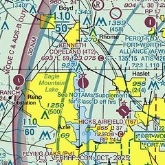
|
| Airport distance calculator |
|---|
|
|
| Sunrise and sunset |
|---|
|
Times for 04-Jul-2026
| | Local
(UTC-5) | | Zulu
(UTC) |
|---|
| Morning civil twilight | | 05:59 | | 10:59 |
| Sunrise | | 06:27 | | 11:27 |
| Sunset | | 20:41 | | 01:41 |
| Evening civil twilight | | 21:10 | | 02:10 |
|
| Current date and time |
|---|
| Zulu (UTC) | 04-Jul-2026 23:23:12 |
|---|
| Local (UTC-5) | 04-Jul-2026 18:23:12 |
|---|
|
| METAR |
|---|
KAFW
9nm E | 042253Z 19003KT 10SM FEW080 BKN160 BKN250 37/18 A2990 RMK AO2 SLP106 T03720178 PNO $
|
KFTW
11nm SE | 042253Z 19007KT 10SM SCT080 38/18 A2990 RMK AO2 SLP113 T03780183 $
|
KNFW
13nm S | 042252Z AUTO 19006KT 10SM CLR 37/18 A2991 RMK AO2 SLP111 T03720178 CHINO S $
|
KLUD
17nm N | 118.22 940-927-2365
042255Z AUTO 15007KT 4SM HZ CLR 37/16 A2992 RMK AO2 T03700159
|
KDTO
20nm NE | 042253Z 18011KT 10SM CLR 37/19 A2990 RMK AO2 SLP114 T03670189
|
|
| TAF |
|---|
KAFW
9nm E | 042040Z 0421/0518 18011KT P6SM SCT060
|
KFTW
11nm SE | 042040Z 0421/0518 18011KT P6SM SCT060
|
|
| NOTAMs |
|---|
NOTAMs are issued by the DoD/FAA and will open in a separate window not controlled by AirNav.
|
|


