FAA INFORMATION EFFECTIVE 19 MARCH 2026
Location
| FAA Identifier: | 56F |
| Lat/Long: | 32-49-27.5000N 100-24-46.2000W
32-49.458333N 100-24.770000W
32.8243056,-100.4128333
(estimated) |
| Elevation: | 1941 ft. / 592 m (estimated) |
| Variation: | 08E (1985) |
| From city: | 3 miles SE of central business district of the associated city |
| Time zone: | UTC -5 (UTC -6 during Standard Time) |
| Zip code: | 79546 |
Airport Operations
| Airport use: | Open to the public |
| Activation date: | 10/1975 |
| Control tower: | no |
| ARTCC: | FORT WORTH CENTER |
| FSS: | FORT WORTH FLIGHT SERVICE STATION |
| NOTAMs facility: | FTW (NOTAM-D service available) |
| Attendance: | UNATNDD |
| Wind indicator: | lighted |
| Segmented circle: | yes |
| Lights: | SS-SR |
| Beacon: | white-green (lighted land airport)
Operates sunset to sunrise. |
Airport Communications
Nearby radio navigation aids
| VOR radial/distance | | VOR name | | Freq | | Var |
|---|
| ABIr297/34.6 | | ABILENE VORTAC | | 113.70 | | 10E |
Airport Services
| Parking: | tiedowns |
| Airframe service: | NONE |
| Powerplant service: | NONE |
| Bottled oxygen: | NONE |
| Bulk oxygen: | NONE |
Runway Information
Runway 16/34
| Dimensions: | 3300 x 60 ft. / 1006 x 18 m |
| Surface: | asphalt, in fair condition |
| Weight bearing capacity: | |
| Runway edge lights: | medium intensity |
| RUNWAY 16 | | RUNWAY 34 |
| Latitude: | 32-49.723547N | | 32-49.194312N |
| Longitude: | 100-24.845772W | | 100-24.695052W |
| Elevation: | 1939.0 ft. | | 1934.0 ft. |
| Traffic pattern: | left | | left |
| Runway heading: | 158 magnetic, 166 true | | 339 magnetic, 347 true |
| Obstructions: | 20 ft. trees, 440 ft. from runway, 150 ft. left and right of centerline, 12:1 slope to clear | | 15 ft. road, 500 ft. from runway, 155 ft. left and right of centerline, 20:1 slope to clear |
Runway 7/25
| Dimensions: | 2800 x 50 ft. / 853 x 15 m |
| Surface: | turf, in fair condition |
| RUNWAY 7 | | RUNWAY 25 |
| Traffic pattern: | left | | left |
| Displaced threshold: | 200 ft. | | no |
| Obstructions: | 30 ft. pline, 65 ft. from runway, 155 ft. left and right of centerline, 2:1 slope to clear | | 22 ft. trees, 190 ft. from runway, 45 ft. left of centerline, 8:1 slope to clear |
Airport Ownership and Management from official FAA records
| Ownership: | Publicly-owned |
| Owner: | FISHER COUNTY
P.O. BOX 306
ROBY, TX 79543
Phone 325-776-2151 |
| Manager: | JUDGE KEN HOLT
P.O. BOX 306
ROBY, TX 79543
Phone 325-776-2151 |
Additional Remarks
| - | AGRICULTURAL ACFT ACT INVOF ARPT. |
| - | FOR CD CTC FORT WORTH ARTCC AT 817-858-7584. |
Instrument Procedures
There are no published instrument procedures at 56F.
Some nearby airports with instrument procedures:
KSWW - Avenger Field Airport (22 nm S)
KSNK - Winston Field Airport (28 nm W)
F56 - Arledge Field Airport (35 nm E)
KDYS - Dyess Air Force Base (37 nm SE)
15F - Haskell Municipal Airport (41 nm NE)
|
|

Road maps at:
MapQuest
Bing
Google
| Aerial photo |
|---|
WARNING: Photo may not be current or correct
 Photo by Chris Davis
Photo taken 25-Aug-2009
Photo by Chris Davis
Photo taken 25-Aug-2009
Do you have a better or more recent aerial photo of Fisher County Airport that you would like to share? If so, please send us your photo.
|
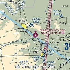
| Sectional chart |
|---|
|
| Airport distance calculator |
|---|
|
|
| Sunrise and sunset |
|---|
|
Times for 25-Mar-2026
| | Local
(UTC-5) | | Zulu
(UTC) |
|---|
| Morning civil twilight | | 07:15 | | 12:15 |
| Sunrise | | 07:40 | | 12:40 |
| Sunset | | 19:56 | | 00:56 |
| Evening civil twilight | | 20:20 | | 01:20 |
|
| Current date and time |
|---|
| Zulu (UTC) | 26-Mar-2026 04:10:48 |
|---|
| Local (UTC-5) | 25-Mar-2026 23:10:48 |
|---|
|
| METAR |
|---|
KSWW
22nm S | 260355Z AUTO 17009KT 10SM 24/09 A2999 RMK AO2 T02410092
|
KSNK
28nm W | 260355Z AUTO 18010G15KT 10SM CLR 26/09 A2997 RMK AO2 T02590091
|
KDYS
38nm SE | 260355Z AUTO 17009KT 10SM CLR 23/11 A2994 RMK AO2 SLP117 T02300107
|
|
| TAF |
|---|
KDYS
38nm SE | 251340Z 2513/2617 18012G18KT 9999 SKC QNH2999INS BECMG 2516/2517 18012G18KT 9999 SKC QNH2989INS BECMG 2612/2613 18015G25KT 9999 FEW025 QNH2994INS TX33/2522Z TN19/2612Z
|
KABI
44nm SE | 251720Z 2518/2618 19014G23KT P6SM SKC FM260100 16012KT P6SM SKC FM261100 17013G23KT P6SM SKC
|
|
| NOTAMs |
|---|
NOTAMs are issued by the DoD/FAA and will open in a separate window not controlled by AirNav.
|
|


