FAA INFORMATION EFFECTIVE 10 JULY 2025
Location
| FAA Identifier: | 5R2 |
| Lat/Long: | 30-23-22.0000N 088-45-12.4000W
30-23.366667N 088-45.206667W
30.3894444,-88.7534444
(estimated) |
| Elevation: | 20 ft. / 6.1 m (surveyed) |
| Variation: | 02E (1985) |
| From city: | 3 miles E of OCEAN SPRINGS, MS |
| Time zone: | UTC -5 (UTC -6 during Standard Time) |
| Zip code: | 39564 |
Airport Operations
| Airport use: | Open to the public |
| Control tower: | no |
| ARTCC: | HOUSTON CENTER |
| FSS: | GREENWOOD FLIGHT SERVICE STATION |
| NOTAMs facility: | GWO (NOTAM-D service available) |
| Attendance: | UNATNDD |
| Wind indicator: | lighted, ACTVT LGTD WINDSOCK - CTAF. |
| Segmented circle: | no |
| Lights: | ACTVT NON STD REIL RWY 18 & 36; MIRL RWY 18/36 - CTAF. |
| Beacon: | white-green (lighted land airport)
BCN OTS. |
Airport Communications
| CTAF/UNICOM: | 122.7 |
| GULFPORT APPROACH: | 124.6 ;130-309 |
| GULFPORT DEPARTURE: | 124.6 ;130-309 |
| WX ASOS at PQL (12 nm E): | 135.175 (228-474-2836) |
| WX ASOS at GPT (16 nm W): | 119.45 (228-867-9937) |
Nearby radio navigation aids
| VOR radial/distance | | VOR name | | Freq | | Var |
|---|
| GPTr092/16.8 | | GULFPORT VORTAC | | 109.00 | | 02E |
| SJIr220/28.7 | | SEMMES VORTAC | | 115.30 | | 05E |
| BFMr246/38.5 | | BROOKLEY VORTAC | | 116.35 | | 04E |
| NDB name | | Hdg/Dist | | Freq | | Var | | ID |
|---|
| WISLE | | 227/32.2 | | 248 | | 01W | | MOB | -- --- -... |
Airport Services
| Fuel available: | 100LL |
| Parking: | hangars and tiedowns |
| Bottled oxygen: | NONE |
| Bulk oxygen: | NONE |
Runway Information
Runway 18/36
| Dimensions: | 3500 x 50 ft. / 1067 x 15 m |
| Surface: | asphalt, in good condition |
| Weight bearing capacity: | |
| Runway edge lights: | medium intensity |
| RUNWAY 18 | | RUNWAY 36 |
| Latitude: | 30-23.669167N | | 30-23.092000N |
| Longitude: | 088-45.214333W | | 088-45.201000W |
| Elevation: | 20.0 ft. | | 20.0 ft. |
| Traffic pattern: | left | | left |
| Runway heading: | 177 magnetic, 179 true | | 357 magnetic, 359 true |
| Markings: | basic, in good condition | | basic, in good condition |
| Runway end identifier lights: | yes | | yes |
| Touchdown point: | yes, no lights | | yes, no lights |
| Obstructions: | 40 ft. trees, 480 ft. from runway, 120 ft. left of centerline, 7:1 slope to clear | | 30 ft. trees, 500 ft. from runway, 10 ft. both sides of centerline, 10:1 slope to clear |
Airport Ownership and Management from official FAA records
| Ownership: | Privately-owned |
| Owner: | AUST PROPERTIES LLC
8600 BLUEBERRY RD
OCEAN SPRINGS, MS 39564
Phone 228-617-4274 |
| Manager: | JOHN AUST
8600 BLUEBERRY RD
OCEAN SPRINGS, MS 39564
Phone 228-617-4274
FBO PHONE 228-617-4274. |
Additional Remarks
| - | FOR CD CTC GULFPORT APCH AT 228-265-6151, WHEN APCH CLSD CTC HOUSTON ARTCC AT 281-230-5622. |
| - | PILOT MUST PRVD THEIR OWN TIEDOWN ROPES. |
Instrument Procedures
There are no published instrument procedures at 5R2.
Some nearby airports with instrument procedures:
KBIX - Keesler Air Force Base (9 nm W)
KPQL - Trent Lott International Airport (12 nm E)
KGPT - Gulfport-Biloxi International Airport (16 nm W)
2R5 - St Elmo Airport (26 nm E)
KMOB - Mobile Regional Airport (32 nm NE)
|
|

Road maps at:
MapQuest
Bing
Google
| Aerial photo |
|---|
WARNING: Photo may not be current or correct
 Photo by Chris Stelly
Taken in January 2013
looking north.
Photo by Chris Stelly
Taken in January 2013
looking north.
Do you have a better or more recent aerial photo of Ocean Springs Airport that you would like to share? If so, please send us your photo.
|
| Sectional chart |
|---|
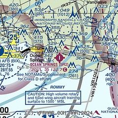
|
| Airport distance calculator |
|---|
|
|
| Sunrise and sunset |
|---|
|
Times for 02-Aug-2025
| | Local
(UTC-5) | | Zulu
(UTC) |
|---|
| Morning civil twilight | | 05:49 | | 10:49 |
| Sunrise | | 06:15 | | 11:15 |
| Sunset | | 19:48 | | 00:48 |
| Evening civil twilight | | 20:14 | | 01:14 |
|
| Current date and time |
|---|
| Zulu (UTC) | 02-Aug-2025 13:15:16 |
|---|
| Local (UTC-5) | 02-Aug-2025 08:15:16 |
|---|
|
| METAR |
|---|
KBIX
9nm W | 021255Z AUTO 06007KT 10SM CLR 27/24 A3005 RMK AO2 SLP179 T02690235
|
KPQL
12nm E | 021253Z AUTO 01005KT 10SM CLR 26/25 A3007 RMK AO2 SLP183 T02610250
|
KGPT
17nm W | 021253Z 04005KT 10SM CLR 26/24 A3006 RMK AO2 SLP179 T02610239
|
|
| TAF |
|---|
KBIX
9nm W | 020200Z 0202/0308 VRB06KT 9999 FEW040 SCT250 QNH3003INS BECMG 0217/0218 23012KT 9999 VCTS SCT035CB SCT120 BKN250 QNH2996INS TEMPO 0219/0224 VRB15G25KT 2400 -TSRA BKN025CB OVC120 BECMG 0301/0302 VRB06KT 9999 NSW FEW035 SCT120 BKN200 QNH2997INS TX33/0219Z TN25/0210Z LAST NO AMDS AFT 0202 NEXT 0410
|
KGPT
17nm W | 021133Z 0212/0312 03004KT P6SM SCT250 FM021900 25005KT P6SM -TSRA SCT026CB BKN070 FM030100 VRB03KT P6SM FEW027 SCT100 PROB30 0301/0307 4SM -TSRA BKN027CB BKN035
|
|
| NOTAMs |
|---|
NOTAMs are issued by the DoD/FAA and will open in a separate window not controlled by AirNav.
|
|

