FAA INFORMATION EFFECTIVE 16 APRIL 2026
Location
| FAA Identifier: | 61A |
| Lat/Long: | 31-58-47.1000N 087-20-20.8000W
31-58.785000N 087-20.346667W
31.9797500,-87.3391111
(estimated) |
| Elevation: | 142.9 ft. / 43.6 m (surveyed) |
| Variation: | 03W (2020) |
| From city: | 3 miles SW of CAMDEN, AL |
| Time zone: | UTC -5 (UTC -6 during Standard Time) |
| Zip code: | 36726 |
Airport Operations
| Airport use: | Open to the public |
| Activation date: | 01/1964 |
| Control tower: | no |
| ARTCC: | ATLANTA CENTER |
| FSS: | ANNISTON FLIGHT SERVICE STATION |
| NOTAMs facility: | ANB (NOTAM-D service available) |
| Attendance: | UNATNDD |
| Wind indicator: | lighted |
| Segmented circle: | no |
| Lights: | ACTVT PAPI RWY 18 & 36; MIRL RWY 18/36 - CTAF. |
| Beacon: | white-green (lighted land airport)
Operates sunset to sunrise. |
Airport Communications
- APCH/DEP SVC PRVDD BY ATLANTA ARTCC (ZTL) ON 120.55/270.25 (MONTGOMERY RCAG).
Nearby radio navigation aids
| VOR radial/distance | | VOR name | | Freq | | Var |
|---|
| MVCr357/31.2 | | MONROEVILLE VORTAC | | 116.80 | | 04E |
Airport Services
| Parking: | tiedowns |
| Airframe service: | NONE |
| Powerplant service: | NONE |
| Bottled oxygen: | NONE |
| Bulk oxygen: | NONE |
Runway Information
Runway 18/36
| Dimensions: | 4303 x 80 ft. / 1312 x 24 m |
| Surface: | asphalt/aggregate friction seal coat, in fair condition
RWY SFC TREATMENT HAS FADED/STREAKED THRUT RWY PAVEMENT SFCS. |
| Weight bearing capacity: | |
| Runway edge lights: | medium intensity |
| RUNWAY 18 | | RUNWAY 36 |
| Latitude: | 31-59.139663N | | 31-58.430107N |
| Longitude: | 087-20.352702W | | 087-20.341228W |
| Elevation: | 142.7 ft. | | 142.3 ft. |
| Traffic pattern: | left | | left |
| Runway heading: | 182 magnetic, 179 true | | 002 magnetic, 359 true |
| Markings: | nonprecision, in fair condition | | nonprecision, in fair condition |
| Visual slope indicator: | 2-light PAPI on left (3.50 degrees glide path) | | 2-light PAPI on left (3.50 degrees glide path) |
| Touchdown point: | yes, no lights | | yes, no lights |
| Obstructions: | 9 ft. tree, 270 ft. from runway, 1 ft. right of centerline, 7:1 slope to clear | | 12 ft. tree, 387 ft. from runway, 20 ft. right of centerline, 15:1 slope to clear |
Airport Ownership and Management from official FAA records
| Ownership: | Publicly-owned |
| Owner: | CITY OF CAMDEN
108 WATER STREET
CAMDEN, AL 36726
Phone 334-456-1044 |
| Manager: | RALEIGH WILKERSON
108 WATER STREET
CAMDEN, AL 36726
Phone 334-830-1654 |
Additional Remarks
| - | FOR CD CTC ATLANTA ARTCC AT 770-210-7692. |
Instrument Procedures
NOTE: All procedures below are presented as PDF files. If you need a reader for these files, you should download the free Adobe Reader.NOT FOR NAVIGATION. Please procure official charts for flight.
FAA instrument procedures published for use from 16 April 2026 at 0901Z to 14 May 2026 at 0900Z.
IAPs - Instrument Approach Procedures |
|---|
| RNAV (GPS) RWY 18 **CHANGED** | |
download (184KB) |
| RNAV (GPS) RWY 36 **CHANGED** | |
download (186KB) |
| NOTE: Special Take-Off Minimums/Departure Procedures apply | |
download (305KB) |
Other nearby airports with instrument procedures:
KSEM - Craig Field Airport (28 nm NE)
KMVC - Monroe County Aeroplex Airport (31 nm S)
A08 - Vaiden Field Airport (32 nm N)
KGZH - Evergreen Regional Airport/Middleton Field (37 nm SE)
KPRN - Mac Crenshaw Memorial Airport (38 nm E)
|
|

Road maps at:
MapQuest
Bing
Google
| Aerial photo |
|---|
WARNING: Photo may not be current or correct

Do you have a better or more recent aerial photo of Camden Municipal Airport that you would like to share? If so, please send us your photo.
|
| Sectional chart |
|---|
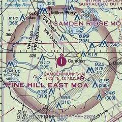
|
| Airport distance calculator |
|---|
|
|
| Sunrise and sunset |
|---|
|
Times for 03-May-2026
| | Local
(UTC-5) | | Zulu
(UTC) |
|---|
| Morning civil twilight | | 05:36 | | 10:36 |
| Sunrise | | 06:03 | | 11:03 |
| Sunset | | 19:30 | | 00:30 |
| Evening civil twilight | | 19:56 | | 00:56 |
|
| Current date and time |
|---|
| Zulu (UTC) | 03-May-2026 19:22:21 |
|---|
| Local (UTC-5) | 03-May-2026 14:22:21 |
|---|
|
| METAR |
|---|
KSEM
28nm NE | 031855Z AUTO 30009KT 10SM CLR 23/05 A3013 RMK AO2
|
KGZH
37nm SE | 031853Z AUTO VRB05G16KT 10SM CLR 23/04 A3013 RMK AO2 SLP201 T02330044
|
KPRN
38nm E | 031900Z AUTO 29008KT 10SM CLR 22/03 A3012 RMK AO2 SLP148 T02170033
|
|
| NOTAMs |
|---|
NOTAMs are issued by the DoD/FAA and will open in a separate window not controlled by AirNav.
|
|

