FAA INFORMATION EFFECTIVE 09 JULY 2026
Location
| FAA Identifier: | 6J4 |
| Lat/Long: | 33-55-36.4550N 081-47-40.6600W
33-55.607583N 081-47.677667W
33.9267931,-81.7946278
(estimated) |
| Elevation: | 539.2 ft. / 164 m (estimated) |
| Variation: | 06W (2010) |
| From city: | 4 miles S of SALUDA, SC |
| Time zone: | UTC -4 (UTC -5 during Standard Time) |
| Zip code: | 29138 |
Airport Operations
| Airport use: | Open to the public |
| Activation date: | 01/1970 |
| Control tower: | no |
| ARTCC: | ATLANTA CENTER |
| FSS: | ANDERSON FLIGHT SERVICE STATION |
| NOTAMs facility: | AND (NOTAM-D service available) |
| Attendance: | MON-FRI 0800-1700, ALL SAT 0800-1200 |
| Wind indicator: | lighted |
| Segmented circle: | yes |
| Lights: | ACTVT PAPI RWY 01 & 19; MIRL RWY 01/19 - CTAF. |
| Beacon: | white-green (lighted land airport)
Operates sunset to sunrise. |
Airport Communications
| CTAF: | 122.9 |
| AUGUSTA APPROACH: | 119.15 124.15 ;WHEN AUGUSTA APCH CTL CLSD |
| COLUMBIA APPROACH: | 126.8 |
| AUGUSTA DEPARTURE: | 119.15 124.15 ;WHEN AUGUSTA APCH CTL CLSD |
| COLUMBIA DEPARTURE: | 126.8 |
| WX AWOS-3PT at AIK (18 nm S): | 118.025 (803-643-8664) |
Nearby radio navigation aids
| VOR radial/distance | | VOR name | | Freq | | Var |
|---|
| IRQr058/22.6 | | COLLIERS VORTAC | | 113.90 | | 04W |
| CAEr278/37.1 | | COLUMBIA VORTAC | | 114.70 | | 02W |
| NDB name | | Hdg/Dist | | Freq | | Var | | ID |
|---|
| AIKEN | | 346/17.5 | | 347 | | 06W | | AIK | .- .. -.- |
| EMORY | | 024/29.6 | | 385 | | 04W | | EMR | . -- .-. |
Airport Services
| Fuel available: | 100LL |
| Parking: | hangars and tiedowns |
| Airframe service: | MAJOR |
| Powerplant service: | MAJOR |
| Bottled oxygen: | NONE |
| Bulk oxygen: | NONE |
Runway Information
Runway 1/19
| Dimensions: | 3189 x 60 ft. / 972 x 18 m |
| Surface: | asphalt, in good condition |
| Weight bearing capacity: | |
| Runway edge lights: | medium intensity |
| RUNWAY 1 | | RUNWAY 19 |
| Latitude: | 33-55.347667N | | 33-55.867500N |
| Longitude: | 081-47.725000W | | 081-47.630333W |
| Elevation: | 536.8 ft. | | 522.3 ft. |
| Traffic pattern: | left | | left |
| Runway heading: | 015 magnetic, 009 true | | 195 magnetic, 189 true |
| Markings: | nonprecision, in good condition | | nonprecision, in good condition |
| Visual slope indicator: | 2-light PAPI on left (3.00 degrees glide path) | | 2-light PAPI on left |
| Runway end identifier lights: | no | | no |
| Touchdown point: | yes, no lights | | yes, no lights |
| Obstructions: | 64 ft. tree, 1891 ft. from runway, 220 ft. left of centerline, 26:1 slope to clear | | 133 ft. tree, 2362 ft. from runway, 319 ft. right of centerline, 16:1 slope to clear |
Airport Ownership and Management from official FAA records
| Ownership: | Publicly-owned |
| Owner: | SALUDA COUNTY
400 WEST HIGHLAND STREET
SALUDA, SC 29138
Phone 864-445-4500 |
| Manager: | JILL WARREN
111 LAW ENFORCEMENT DRIVE
SALUDA, SC 29138
Phone 864-445-2529 |
Additional Remarks
| - | 30 FT DROP OFF N END OF RWY 01. |
| - | FOR CD CTC AUGUSTA APCH AT 706-771-1777. WHEN AUGUSTA APCH CLSD, FOR CD CTC COLUMBIA APCH AT 803-822-4511. |
Instrument Procedures
NOTE: All procedures below are presented as PDF files. If you need a reader for these files, you should download the free Adobe Reader.NOT FOR NAVIGATION. Please procure official charts for flight.
FAA instrument procedures published for use from 09 July 2026 at 0901Z to 06 August 2026 at 0900Z.
IAPs - Instrument Approach Procedures |
|---|
| RNAV (GPS) RWY 01 | |
download (201KB) |
| RNAV (GPS) RWY 19 | |
download (221KB) |
| NOTE: Special Take-Off Minimums/Departure Procedures apply | |
download (141KB) |
Other nearby airports with instrument procedures:
KAIK - Aiken Regional Airport (18 nm S)
KEOE - Newberry County Airport (24 nm N)
KGRD - Greenwood County Airport (27 nm NW)
6J0 - Lexington County Airport (28 nm E)
KDNL - Daniel Field Airport (30 nm SW)
|
|

Road maps at:
MapQuest
Bing
Google
| Aerial photo |
|---|
WARNING: Photo may not be current or correct

Do you have a better or more recent aerial photo of Saluda County Airport that you would like to share? If so, please send us your photo.
|
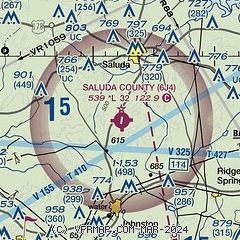
| Sectional chart |
|---|
|
| Airport distance calculator |
|---|
|
|
| Sunrise and sunset |
|---|
|
Times for 22-Jul-2026
| | Local
(UTC-4) | | Zulu
(UTC) |
|---|
| Morning civil twilight | | 06:05 | | 10:05 |
| Sunrise | | 06:33 | | 10:33 |
| Sunset | | 20:34 | | 00:34 |
| Evening civil twilight | | 21:02 | | 01:02 |
|
| Current date and time |
|---|
| Zulu (UTC) | 22-Jul-2026 21:06:51 |
|---|
| Local (UTC-4) | 22-Jul-2026 17:06:51 |
|---|
|
| METAR |
|---|
KAIK
18nm S | 222055Z AUTO 22011KT 10SM BKN048 BKN060 BKN070 33/22 A2998 RMK AO2 T03280221
|
KEOE
24nm N | 222055Z AUTO 21010G16KT 10SM CLR 33/21 A2999 RMK AO2
|
KGRD
26nm NW | 222056Z AUTO 21011KT 10SM SCT045 BKN060 32/21 A2997 RMK AO2 SLP140 T03170211 56012
|
KDNL
30nm SW | 222053Z AUTO 22012KT 10SM FEW080 33/21 A2997 RMK AO2 SLP141 T03330211 56014
|
KCAE
34nm E | 222056Z 22007G19KT 7SM SCT055 BKN150 34/20 A2994 RMK AO2 SLP133 T03390200 56013 $
|
KAGS
35nm S | 222053Z 22008KT 10SM SCT045 BKN080 33/22 A2994 RMK AO2 SLP136 T03330222 56013
|
|
| TAF |
|---|
KAIK
18nm S | 221722Z 2218/2318 22012G20KT P6SM VCSH SCT060 BKN250 FM230100 20007KT P6SM BKN250 FM231400 25010KT P6SM SCT070 BKN250
|
|
| NOTAMs |
|---|
NOTAMs are issued by the DoD/FAA and will open in a separate window not controlled by AirNav.
|
|

