FAA INFORMATION EFFECTIVE 11 JUNE 2026
Location
| FAA Identifier: | 7F3 |
| Lat/Long: | 33-02-10.4000N 096-14-35.3000W
33-02.173333N 096-14.588333W
33.0362222,-96.2431389
(estimated) |
| Elevation: | 541.6 ft. / 165.1 m (surveyed) |
| Variation: | 06E (1985) |
| From city: | 2 miles SW of CADDO MILLS, TX |
| Time zone: | UTC -5 (UTC -6 during Standard Time) |
| Zip code: | 75135 |
Airport Operations
| Airport use: | Open to the public |
| Control tower: | no |
| ARTCC: | FORT WORTH CENTER |
| FSS: | FORT WORTH FLIGHT SERVICE STATION |
| NOTAMs facility: | FTW (NOTAM-D service available) |
| Attendance: | MON-SAT 0900-1800
FOR ATTENDANT OTHER TIMES; CALL 214-585-9953. |
| Wind indicator: | lighted |
| Segmented circle: | yes |
| Lights: | ACTVT MIRL RWY 18/36 - CTAF. |
| Beacon: | white-green (lighted land airport)
Operates sunset to sunrise. |
Airport Communications
| CTAF/UNICOM: | 122.8 |
| WX AWOS-3 at GVT (9 nm E): | 133.425 (903-455-7703) |
| WX AWOS-3PT at F46 (12 nm SW): | 121.25 (469-991-7392) |
| WX ASOS at TKI (19 nm NW): | PHONE 972-548-8525 |
| WX ASOS at TRL (20 nm S): | 119.275 (972-551-1334) |
- UNICOM NOT MNT.
- APCH/DEP SVC PRVDD BY FORT WORTH ARTCC (ZFW) ON FREQS 132.025/317.75 (CUMBY RCAG).
Nearby radio navigation aids
| VOR radial/distance | | VOR name | | Freq | | Var |
|---|
| BYPr175/30.1 | | BONHAM VORTAC | | 114.60 | | 06E |
| CVEr069/34.4 | | COWBOY VOR/DME | | 116.20 | | 06E |
Airport Services
| Fuel available: | 100LL
100LL:FUEL SELF SERVE. |
| Parking: | tiedowns |
| Bottled oxygen: | NONE |
| Bulk oxygen: | NONE |
Runway Information
Runway 13/31
| Dimensions: | 4000 x 150 ft. / 1219 x 46 m |
| Surface: | concrete, in good condition |
| Weight bearing capacity: | |
| RUNWAY 13 | | RUNWAY 31 |
| Latitude: | 33-02.452500N | | 33-01.977317N |
| Longitude: | 096-14.733383W | | 096-14.190300W |
| Elevation: | 541.6 ft. | | 536.9 ft. |
| Traffic pattern: | left | | left |
| Runway heading: | 130 magnetic, 136 true | | 310 magnetic, 316 true |
| Markings: | basic, in good condition | | basic, in good condition |
| Touchdown point: | yes, no lights | | yes, no lights |
| Obstructions: | 35 ft. tree, 760 ft. from runway, 95 ft. left of centerline, 16:1 slope to clear | | 31 ft. tree, 850 ft. from runway, 20:1 slope to clear |
Runway 18/36
| Dimensions: | 4000 x 75 ft. / 1219 x 23 m |
| Surface: | concrete, in good condition |
| Weight bearing capacity: | |
| Runway edge lights: | medium intensity |
| RUNWAY 18 | | RUNWAY 36 |
| Latitude: | 33-02.460900N | | 33-01.801383N |
| Longitude: | 096-14.708150W | | 096-14.723100W |
| Elevation: | 541.4 ft. | | 535.3 ft. |
| Traffic pattern: | left | | left |
| Runway heading: | 175 magnetic, 181 true | | 355 magnetic, 001 true |
| Markings: | nonprecision, in good condition | | nonprecision, in good condition |
| Touchdown point: | yes, no lights | | yes, no lights |
| Obstructions: | 54 ft. tree, 1975 ft. from runway, 250 ft. left of centerline, 32:1 slope to clear | | 30 ft. tree, 480 ft. from runway, 254 ft. right of centerline, 9:1 slope to clear |
Airport Ownership and Management from official FAA records
| Ownership: | Publicly-owned |
| Owner: | CITY OF CADDO MILLS
2313 MAIN ST., PO BOX 490
CADDO MILLS, TX 75135
Phone 903-527-3116 |
| Manager: | PHIL EATON
4246 N, FM 1565, PO BOX 490
CADDO MILLS, TX 75135
Phone 214-585-9953 |
Additional Remarks
| - | ROCKET LAUNCH AREA ADJ TO TXY EAST OF RWY 13/31, MIDWAY. |
| - | FOR CD CTC FORT WORTH ARTCC AT 817-858-7584. |
Instrument Procedures
NOTE: All procedures below are presented as PDF files. If you need a reader for these files, you should download the free Adobe Reader.NOT FOR NAVIGATION. Please procure official charts for flight.
FAA instrument procedures published for use from 11 June 2026 at 0901Z to 09 July 2026 at 0900z.
IAPs - Instrument Approach Procedures |
|---|
| RNAV (GPS) RWY 36 | |
download (223KB) |
Other nearby airports with instrument procedures:
KGVT - Majors Airport (9 nm E)
F46 - Ralph M Hall/Rockwall Municipal Airport (12 nm SW)
KTKI - McKinney National Airport (19 nm NW)
KTRL - Terrell Municipal Airport (20 nm S)
KHQZ - Mesquite Metro Airport (23 nm SW)
|
|

Road maps at:
MapQuest
Bing
Google
| Aerial photo |
|---|
WARNING: Photo may not be current or correct
 Photo contributed by J. Herz
Do you have a better or more recent aerial photo of Caddo Mills Municipal Airport that you would like to share? If so, please send us your photo.
|
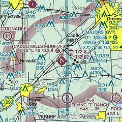
| Sectional chart |
|---|
|
| Airport distance calculator |
|---|
|
|
| Sunrise and sunset |
|---|
|
Times for 19-Jun-2026
| | Local
(UTC-5) | | Zulu
(UTC) |
|---|
| Morning civil twilight | | 05:49 | | 10:49 |
| Sunrise | | 06:17 | | 11:17 |
| Sunset | | 20:35 | | 01:35 |
| Evening civil twilight | | 21:04 | | 02:04 |
|
| Current date and time |
|---|
| Zulu (UTC) | 19-Jun-2026 12:58:38 |
|---|
| Local (UTC-5) | 19-Jun-2026 07:58:38 |
|---|
|
| METAR |
|---|
KGVT
9nm E | 191230Z AUTO 29003KT 10SM VCTS BKN012 OVC020 26/26 A2994 RMK AO2 LTG DSNT ALQDS
|
KF46
12nm SW | 191235Z AUTO 26004KT 10SM VCTS OVC012 27/24 A2994 RMK AO2 LTG DSNT ALQS T02650242
|
KTRL
19nm S | 191253Z AUTO 01005KT 5SM BR BKN011 OVC018 27/26 A2991 RMK AO2 LTG DSNT W-NE SLP121 T02670256
|
KTKI
19nm NW | 191253Z 31019G34KT 1 3/4SM +TSRA BR OVC032 22/21 A2997 RMK AO2 PK WND 31039/1221 LTG DSNT ALQDS RAB1156 SLP143 T02170206 PNO $
|
|
| TAF |
|---|
KDAL
33nm W | 191126Z 1912/2012 12008KT 6SM -SHRA VCTS BKN040CB OVC150 TEMPO 1912/1916 30015G30KT 2SM TSRA OVC015CB FM191800 05005KT P6SM -RA BKN040 FM192000 10008KT P6SM FEW020 OVC250 FM200900 09006KT P6SM BKN015
|
KDFW
40nm W | 191120Z 1912/2018 12008KT 6SM -SHRA VCTS BKN040CB OVC150 TEMPO 1912/1915 30015G30KT 2SM TSRA OVC015CB FM191800 05005KT P6SM -RA BKN040 FM192000 10008KT P6SM FEW020 OVC250 FM200900 09006KT P6SM BKN015 FM201500 10007KT P6SM FEW030 SCT250
|
|
| NOTAMs |
|---|
NOTAMs are issued by the DoD/FAA and will open in a separate window not controlled by AirNav.
|
|


