FAA INFORMATION EFFECTIVE 25 DECEMBER 2025
Location
| FAA Identifier: | TRL |
| Lat/Long: | 32-42-30.5800N 096-16-01.5400W
32-42.509667N 096-16.025667W
32.7084944,-96.2670944
(estimated) |
| Elevation: | 474.2 ft. / 144.5 m (surveyed) |
| Variation: | 04E (2005) |
| From city: | 1 mile SE of TERRELL, TX |
| Time zone: | UTC -6 (UTC -5 during Daylight Saving Time) |
| Zip code: | 75160 |
Airport Operations
| Airport use: | Open to the public |
| Activation date: | 04/1941 |
| Control tower: | no |
| ARTCC: | FORT WORTH CENTER |
| FSS: | FORT WORTH FLIGHT SERVICE STATION |
| NOTAMs facility: | TRL (NOTAM-D service available) |
| Attendance: | 0800-2000
FOR ATTENDANT AFT HRS CALL 972-835-5395. CALL IN FEE. |
| Wind indicator: | lighted |
| Segmented circle: | yes |
| Lights: | MIRL RWY 18/36 PRESET LOW INTST; TO INCR INTST & ACTVT RLLS RWY 18, PAPI RWYS 18 & 36 - CTAF. |
| Beacon: | white-green (lighted land airport)
Operates sunset to sunrise. |
Airport Communications
| CTAF/UNICOM: | 123.075 |
| WX ASOS: | 119.275 (972-551-1334) |
| WX AWOS-3 at HQZ (13 nm W): | 118.175 (972-222-7631) |
| WX AWOS-3PT at F46 (16 nm NW): | 121.25 (469-991-7392) |
- APCH/DEP SVC PRVDD BY FORT WORTH ARTCC (ZFW) ON FREQS 132.025/317.75 (CUMBY RCAG).
Nearby radio navigation aids
| VOR radial/distance | | VOR name | | Freq | | Var |
|---|
| CQYr349/31.5 | | CEDAR CREEK VORTAC | | 114.80 | | 06E |
| CVEr103/33.9 | | COWBOY VOR/DME | | 116.20 | | 06E |
Airport Services
| Fuel available: | 100LL JET-A+ |
| Parking: | hangars and tiedowns |
| Airframe service: | MAJOR |
| Powerplant service: | MAJOR |
Runway Information
Runway 18/36
| Dimensions: | 5006 x 75 ft. / 1526 x 23 m |
| Surface: | asphalt, in good condition |
| Weight bearing capacity: | |
| Runway edge lights: | medium intensity |
| RUNWAY 18 | | RUNWAY 36 |
| Latitude: | 32-42.922570N | | 32-42.096925N |
| Longitude: | 096-16.026630W | | 096-16.024760W |
| Elevation: | 474.1 ft. | | 456.1 ft. |
| Traffic pattern: | left | | left |
| Runway heading: | 176 magnetic, 180 true | | 356 magnetic, 360 true |
| Markings: | nonprecision, in good condition | | nonprecision, in good condition |
| Visual slope indicator: | 4-light PAPI on left (3.00 degrees glide path) | | 4-light PAPI on left (3.00 degrees glide path) |
| Approach lights: | RLLS | | |
| Runway end identifier lights: | yes | | yes |
| Touchdown point: | yes, no lights | | yes, no lights |
| Obstructions: | 60 ft. trees, 1175 ft. from runway, 327 ft. right of centerline, 16:1 slope to clear | | 40 ft. trees, 1225 ft. from runway, 445 ft. left and right of centerline, 25:1 slope to clear |
Airport Ownership and Management from official FAA records
| Ownership: | Publicly-owned |
| Owner: | CITY OF TERRELL
201 EAST NASH
TERRELL, TX 75160
Phone 972-551-6600
EXT 2137 |
| Manager: | CHRIS SNAPP, P. E.
400 INDUSTRIAL BLVD.
TERRELL, TX 75160
Phone 972-551-6614
CITY ENGINEER/AMGR. |
Additional Remarks
| - | BIRDS ON AND INVOF ARPT. |
| - | FOR CD CTC FORT WORTH ARTCC AT 817-858-7584. |
Instrument Procedures
NOTE: All procedures below are presented as PDF files. If you need a reader for these files, you should download the free Adobe Reader.NOT FOR NAVIGATION. Please procure official charts for flight.
FAA instrument procedures published for use from 25 December 2025 at 0901z to 22 January 2026 at 0900z.
IAPs - Instrument Approach Procedures |
|---|
| RNAV (GPS) RWY 18 | |
download (242KB) |
| RNAV (GPS) RWY 36 | |
download (212KB) |
| NOTE: Special Alternate Minimums apply | |
download (117KB) |
| NOTE: Special Take-Off Minimums/Departure Procedures apply | |
download (301KB) |
Other nearby airports with instrument procedures:
KHQZ - Mesquite Metro Airport (13 nm W)
F46 - Ralph M Hall/Rockwall Municipal Airport (16 nm NW)
7F3 - Caddo Mills Municipal Airport (20 nm N)
KGVT - Majors Airport (24 nm NE)
KLNC - Lancaster Regional Airport (24 nm W)
|
|

Road maps at:
MapQuest
Bing
Google
| Aerial photo |
|---|
WARNING: Photo may not be current or correct
 Photo by Glen Kitto
Photo taken 27-Oct-2012
looking southwest.
Photo by Glen Kitto
Photo taken 27-Oct-2012
looking southwest.
Do you have a better or more recent aerial photo of Terrell Municipal Airport that you would like to share? If so, please send us your photo.
|
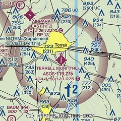
| Sectional chart |
|---|
|
CAUTION: Diagram may not be current

| Airport distance calculator |
|---|
|
|
| Sunrise and sunset |
|---|
|
Times for 10-Jan-2026
| | Local
(UTC-6) | | Zulu
(UTC) |
|---|
| Morning civil twilight | | 07:02 | | 13:02 |
| Sunrise | | 07:29 | | 13:29 |
| Sunset | | 17:36 | | 23:36 |
| Evening civil twilight | | 18:03 | | 00:03 |
|
| Current date and time |
|---|
| Zulu (UTC) | 10-Jan-2026 08:10:29 |
|---|
| Local (UTC-6) | 10-Jan-2026 02:10:29 |
|---|
|
| METAR |
|---|
| KTRL | 100753Z AUTO 34009KT 10SM CLR 11/07 A3014 RMK AO2 SLP204 T01060067 $
|
KHQZ
13nm W | 100755Z AUTO 33013KT 10SM CLR 11/06 A3016 RMK AO1 T01050062
|
KF46
16nm NW | 100755Z AUTO 34013G21KT 10SM CLR 10/06 A3015 RMK AO2 T01010061
|
|
| TAF |
|---|
KDAL
31nm W | 100520Z 1006/1106 33011KT P6SM SCT100 FM100800 34016G26KT P6SM FEW100 FM101200 33017G27KT P6SM SCT015 FM110000 34010KT P6SM SKC
|
|
| NOTAMs |
|---|
NOTAMs are issued by the DoD/FAA and will open in a separate window not controlled by AirNav.
|
|


