FAA INFORMATION EFFECTIVE 04 SEPTEMBER 2025
Location
| FAA Identifier: | 7G8 |
| Lat/Long: | 41-26-58.5440N 081-03-46.5640W
41-26.975733N 081-03.776067W
41.4495956,-81.0629344
(estimated) |
| Elevation: | 1174.3 ft. / 357.9 m (surveyed) |
| Variation: | 09W (2015) |
| From city: | 1 mile SE of MIDDLEFIELD, OH |
| Time zone: | UTC -4 (UTC -5 during Standard Time) |
| Zip code: | 44062 |
Airport Operations
| Airport use: | Open to the public |
| Control tower: | no |
| ARTCC: | CLEVELAND CENTER |
| FSS: | CLEVELAND FLIGHT SERVICE STATION |
| NOTAMs facility: | CLE (NOTAM-D service available) |
| Attendance: | MON-FRI 0900-1700 IREG |
| Pattern altitude: | 2199.3 ft. MSL |
| Wind indicator: | lighted |
| Segmented circle: | no |
| Lights: | ACTVT REIL RWY 11 & 29; PAPI RWY 29; MIRL RWY 11/29 - CTAF. |
| Beacon: | white-green (lighted land airport)
Operates sunset to sunrise. |
Airport Communications
| CTAF/UNICOM: | 123.0 |
| CLEVELAND APPROACH: | 125.35 |
| CLEVELAND DEPARTURE: | 125.35 |
| WX AWOS-3 at POV (17 nm SW): | 118.675 (330-298-9353) |
Nearby radio navigation aids
| VOR radial/distance | | VOR name | | Freq | | Var |
|---|
| CXRr137/6.1 | | CHARDON VOR/DME | | 112.70 | | 05W |
| ACOr021/21.4 | | AKRON VOR/DME | | 114.40 | | 04W |
| NDB name | | Hdg/Dist | | Freq | | Var | | ID |
|---|
| CASTLE | | 320/38.8 | | 272 | | 09W | | UCP | ..- -.-. .--. |
Airport Services
| Fuel available: | 100LL MOGAS
100LL:100LL AVBL H24 VIA CREDIT CARD. |
| Parking: | hangars and tiedowns |
| Airframe service: | NONE |
| Powerplant service: | NONE |
| Bottled oxygen: | NONE |
| Bulk oxygen: | NONE |
Runway Information
Runway 11/29
| Dimensions: | 3500 x 65 ft. / 1067 x 20 m |
| Surface: | asphalt, in good condition |
| Weight bearing capacity: | |
| Runway edge lights: | medium intensity |
| RUNWAY 11 | | RUNWAY 29 |
| Latitude: | 41-27.025532N | | 41-26.925918N |
| Longitude: | 081-04.153235W | | 081-03.398902W |
| Elevation: | 1174.3 ft. | | 1157.9 ft. |
| Traffic pattern: | left | | left |
| Runway heading: | 109 magnetic, 100 true | | 289 magnetic, 280 true |
| Displaced threshold: | 179 ft. | | no |
| Markings: | nonprecision, in good condition | | nonprecision, in good condition |
| Visual slope indicator: | | | 2-light PAPI on left (3.00 degrees glide path) |
| Runway end identifier lights: | yes | | yes |
| Touchdown point: | yes, no lights | | yes, no lights |
| Obstructions: | 45 ft. ant, lighted, 551 ft. from runway, 160 ft. right of centerline, 7:1 slope to clear
+3-6 FT BRUSH, 0-140 FT DIST, 220 FT L. | | none |
Airport Ownership and Management from official FAA records
| Ownership: | Publicly-owned |
| Owner: | GEAUGA CO BOARD OF COMM
COURTHOUSE ANNEX, 231 MAIN ST
CHARDON, OH 44024-1263
Phone 440-285-2222 |
| Manager: | RICHARD BLAMER
PO BOX 1308
MIDDLEFIELD, OH 44062-1308
Phone 440-632-1884
CELL 216-509-8858. |
Additional Remarks
| - | PARL TWY EAST OF TEE HNGRS CLSD PERMLY. |
| - | EXTSV GLDR ACT ON & INVOF ARPT. |
| - | DEER, BIRDS, & OTR WILDLIFE ON & INVOF ARPT. |
| - | FOR CD CTC CLEVELAND APCH AT 216-352-2323. |
| - | ADZY ONLY WX AVBL - 4 CLICKS CTAF. |
Instrument Procedures
NOTE: All procedures below are presented as PDF files. If you need a reader for these files, you should download the free Adobe Reader.NOT FOR NAVIGATION. Please procure official charts for flight.
FAA instrument procedures published for use from 04 September 2025 at 0901Z to 02 October 2025 at 0900z.
IAPs - Instrument Approach Procedures |
|---|
| RNAV (GPS) RWY 11 | |
download (218KB) |
| RNAV (GPS) RWY 29 | |
download (207KB) |
| NOTE: Special Take-Off Minimums/Departure Procedures apply | |
download (164KB) |
Other nearby airports with instrument procedures:
2G1 - Concord Airpark (14 nm NW)
KPOV - Portage County Airport (17 nm SW)
KCGF - Cuyahoga County Airport (20 nm W)
KLNN - Lake County Executive Airport (20 nm NW)
KYNG - Youngstown/Warren Regional Airport (21 nm SE)
|
|

Road maps at:
MapQuest
Bing
Google
| Aerial photo |
|---|
WARNING: Photo may not be current or correct

Do you have a better or more recent aerial photo of Geauga County Airport that you would like to share? If so, please send us your photo.
|
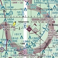
| Sectional chart |
|---|
|
| Airport distance calculator |
|---|
|
|
| Sunrise and sunset |
|---|
|
Times for 22-Sep-2025
| | Local
(UTC-4) | | Zulu
(UTC) |
|---|
| Morning civil twilight | | 06:45 | | 10:45 |
| Sunrise | | 07:13 | | 11:13 |
| Sunset | | 19:21 | | 23:21 |
| Evening civil twilight | | 19:49 | | 23:49 |
|
| Current date and time |
|---|
| Zulu (UTC) | 22-Sep-2025 13:47:46 |
|---|
| Local (UTC-4) | 22-Sep-2025 09:47:46 |
|---|
|
| METAR |
|---|
KPOV
17nm SW | 221335Z AUTO 21005KT 10SM SCT014 BKN030 SCT035 20/17 A3002 RMK AO2 T02000171 PWINO
|
KLNN
19nm NW | 221335Z AUTO 20009G14KT 10SM SCT047 BKN065 BKN120 22/18 A2997 RMK AO1 T02210183
|
KCGF
19nm W | 221245Z 20009KT 10SM SCT095 SCT120 21/18 A2998
|
KYNG
21nm SE | 221251Z 18009KT 10SM FEW018 SCT055 SCT160 BKN250 19/18 A3002 RMK AO2 SLP157 T01940178
|
KHZY
26nm NE | 221253Z AUTO 18007KT 10SM CLR 20/18 A2999 RMK AO2 RAE06 SLP149 P0000 T02000183 $
|
KBKL
28nm W | 221253Z 19013KT 10SM SCT055 BKN080 BKN110 22/18 A2997 RMK AO2 SLP144 T02220178
|
KAKR
31nm SW | 221254Z AUTO 20010KT 10SM FEW014 SCT037 SCT100 21/17 A3001 RMK AO2 SLP156 T02060172
|
|
| TAF |
|---|
KYNG
21nm SE | 221135Z 2212/2312 19008KT P6SM VCSH BKN070 FM221900 25008KT 5SM -SHRA VCTS OVC050CB FM222300 25006KT 4SM -SHRA OVC015 FM230400 18005KT 3SM -SHRA BR OVC007 FM231000 19004KT 2SM BR VCSH OVC007
|
|
| NOTAMs |
|---|
NOTAMs are issued by the DoD/FAA and will open in a separate window not controlled by AirNav.
|
|


