FAA INFORMATION EFFECTIVE 25 DECEMBER 2025
Location
| FAA Identifier: | HZY |
| Lat/Long: | 41-46-40.0000N 080-41-48.4000W
41-46.666667N 080-41.806667W
41.7777778,-80.6967778
(estimated) |
| Elevation: | 926 ft. / 282.2 m (surveyed) |
| Variation: | 09W (2000) |
| From city: | 8 miles SE of ASHTABULA, OH |
| Time zone: | UTC -5 (UTC -4 during Daylight Saving Time) |
| Zip code: | 44047 |
Airport Operations
| Airport use: | Open to the public |
| Control tower: | no |
| ARTCC: | CLEVELAND CENTER |
| FSS: | CLEVELAND FLIGHT SERVICE STATION |
| NOTAMs facility: | HZY (NOTAM-D service available) |
| Attendance: | MON-FRI 0800-1700, ALL SAT-SUN ON CALL
UNATNDD CHRISTMAS & NEW YEARS DAY.
FEE FOR SER AFT HRS & WKENDS CALL AHD 440-855-1126. |
| Wind indicator: | lighted |
| Segmented circle: | no |
| Lights: | ACTVT REIL RWY 09 & 27; HIRL RWY 09/27 - 123.3. PAPI RWY 09 & 27 OPR CONSLY. |
| Beacon: | white-green (lighted land airport)
Operates sunset to sunrise. |
| Landing fee: | no, RAMP FEE FOR TURBINE ACFT. |
Airport Communications
| CTAF/UNICOM: | 122.8 |
| WX ASOS: | 118.325 (440-576-0219) |
| BUFFALO APPROACH: | 121.0 |
| BUFFALO DEPARTURE: | 121.0 |
- APCH/DEP SVC PRVDD BY BUFFALO APCH (BUF) ON 121.0 0600-0000 OR CALL 716-626-6920. APCH/DEP SVC PRVDD BY CLEVELAND ARTCC (ZOB) ON FREQS 127.075/292.175 (WATERFORD RCAG) 0000-0600.
Nearby radio navigation aids
| VOR radial/distance | | VOR name | | Freq | | Var |
|---|
| CXRr058/26.1 | | CHARDON VOR/DME | | 112.70 | | 05W |
Airport Services
| Fuel available: | 100LL JET-A+
100LL:100LL AVBL H24 SELF SVC VIA CREDIT CARD. |
| Parking: | hangars and tiedowns |
| Airframe service: | NONE |
| Powerplant service: | NONE |
| Bottled oxygen: | NONE |
| Bulk oxygen: | NONE |
Runway Information
Runway 9/27
| Dimensions: | 5900 x 100 ft. / 1798 x 30 m |
| Surface: | asphalt/grooved, in good condition |
| Weight bearing capacity: | | PCN 42 /F/C/X/T | | Single wheel: | 70.0 | | Double wheel: | 100.0 | | Double tandem: | 150.0 |
|
| Runway edge lights: | high intensity |
| RUNWAY 9 | | RUNWAY 27 |
| Latitude: | 41-46.570747N | | 41-46.762845N |
| Longitude: | 080-42.442273W | | 080-41.170230W |
| Elevation: | 906.8 ft. | | 926.0 ft. |
| Traffic pattern: | left | | left |
| Runway heading: | 088 magnetic, 079 true | | 268 magnetic, 259 true |
| Displaced threshold: | no | | 400 ft. |
| Declared distances: | TORA:5900 TODA:5900 ASDA:5100 LDA:5100 | | TORA:5900 TODA:5900 ASDA:5500 LDA:5100 |
| Markings: | nonprecision, in good condition | | nonprecision, in good condition |
| Visual slope indicator: | 4-light PAPI on left (3.00 degrees glide path) | | 4-light PAPI on left (3.00 degrees glide path) |
| Runway end identifier lights: | yes | | yes |
| Touchdown point: | yes, no lights | | yes, no lights |
Airport Ownership and Management from official FAA records
| Ownership: | Publicly-owned |
| Owner: | ASHTABULA CO ARPT AUTH
PO BOX 379
JEFFERSON, OH 44047-0379
Phone 440-576-9271 |
| Manager: | LANCE BUSHWEILER
PO BOX 379
JEFFERSON, OH 44047-0379
Phone 440-576-9271
ARPT PHYS ADS: 2382 AIRPORT RD, JEFFERSON, OH 44047-9491. |
Additional Remarks
| - | SNOW REMOVAL OPS DRG ATNDD HRS, MAY BE LTD HOLS & WKENDS. |
| - | SER: ACFT DEICE - TYPE 1 & 4 FLUID, LAV CART, & GPU AVBL. |
| - | FOR CD CTC BUFFALO APCH AT 716-626-6920, WHEN APCH CLSD CTC CLEVELAND ARTCC AT 440-774-0232. |
| - | FLD CONDS UNMON AFT BUS HRS. |
| - | DEER & BIRDS INVOF ARPT. |
Instrument Procedures
NOTE: All procedures below are presented as PDF files. If you need a reader for these files, you should download the free Adobe Reader.NOT FOR NAVIGATION. Please procure official charts for flight.
FAA instrument procedures published for use from 25 December 2025 at 0901z to 22 January 2026 at 0900z.
IAPs - Instrument Approach Procedures |
|---|
| RNAV (GPS) RWY 09 | |
download (220KB) |
| RNAV (GPS) RWY 27 | |
download (215KB) |
| NOTE: Special Take-Off Minimums/Departure Procedures apply | |
download (936KB) |
Other nearby airports with instrument procedures:
2G1 - Concord Airpark (23 nm W)
KGKJ - Port Meadville Airport (23 nm SE)
4G1 - Greenville Municipal Airport (24 nm SE)
7G8 - Geauga County Airport (26 nm SW)
KERI - Erie International Airport/Tom Ridge Field (30 nm NE)
|
|

Road maps at:
MapQuest
Bing
Google
| Aerial photo |
|---|
WARNING: Photo may not be current or correct
 Photo courtesy of R.A. Wiedemann & Associates
Taken in 2020
looking southeast.
Photo courtesy of R.A. Wiedemann & Associates
Taken in 2020
looking southeast.
Do you have a better or more recent aerial photo of Northeast Ohio Regional Airport that you would like to share? If so, please send us your photo.
|
| Sectional chart |
|---|
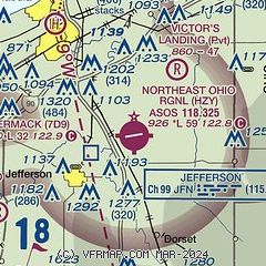
|
CAUTION: Diagram may not be current

| Airport distance calculator |
|---|
|
|
| Sunrise and sunset |
|---|
|
Times for 09-Jan-2026
| | Local
(UTC-5) | | Zulu
(UTC) |
|---|
| Morning civil twilight | | 07:20 | | 12:20 |
| Sunrise | | 07:51 | | 12:51 |
| Sunset | | 17:09 | | 22:09 |
| Evening civil twilight | | 17:40 | | 22:40 |
|
| Current date and time |
|---|
| Zulu (UTC) | 09-Jan-2026 21:28:00 |
|---|
| Local (UTC-5) | 09-Jan-2026 16:28:00 |
|---|
|
| METAR |
|---|
| KHZY | 092103Z AUTO 26020G36KT 10SM BKN027 OVC038 08/03 A2994 RMK AO2 PK WND 26036/2054 PRESRR T00830033
|
|
| TAF |
|---|
KERI
29nm NE | 091720Z 0918/1018 19025G40KT P6SM OVC080 FM092000 24025G45KT P6SM OVC025 FM100000 25008KT P6SM OVC015 FM100900 09007KT P6SM OVC015
|
KYNG
32nm S | 091720Z 0918/1018 21020G35KT P6SM -RA OVC035 FM092100 26018G32KT P6SM OVC025 FM100000 31006KT P6SM OVC015 FM101000 12006KT P6SM OVC015 FM101700 14007KT 4SM -RA HZ OVC015
|
|
| NOTAMs |
|---|
NOTAMs are issued by the DoD/FAA and will open in a separate window not controlled by AirNav.
|
|


