FAA INFORMATION EFFECTIVE 22 JANUARY 2026
Location
| FAA Identifier: | 7S7 |
| Lat/Long: | 48-18-00.5350N 112-15-04.1093W
48-18.008917N 112-15.068488W
48.3001486,-112.2511415
(estimated) |
| Elevation: | 3826 ft. / 1166 m (estimated) |
| Variation: | 18E (1985) |
| From city: | 1 mile S of VALIER, MT |
| Time zone: | UTC -7 (UTC -6 during Daylight Saving Time) |
| Zip code: | 59486 |
Airport Operations
| Airport use: | Open to the public |
| Activation date: | 04/1940 |
| Control tower: | no |
| ARTCC: | SALT LAKE CITY CENTER |
| FSS: | GREAT FALLS FLIGHT SERVICE STATION |
| NOTAMs facility: | GTF (NOTAM-D service available) |
| Attendance: | UNATNDD |
| Wind indicator: | yes |
| Segmented circle: | yes |
Airport Communications
| CTAF: | 122.9 |
| WX ASOS at CTB (19 nm N): | 119.025 (406-873-2939) |
Nearby radio navigation aids
| VOR radial/distance | | VOR name | | Freq | | Var |
|---|
| CTBr150/16.3 | | CUT BANK VOR/DME | | 113.35 | | 17E |
Airport Services
| Parking: | tiedowns |
| Airframe service: | NONE |
| Powerplant service: | NONE |
| Bottled oxygen: | NONE |
| Bulk oxygen: | NONE |
Runway Information
Runway 7/25
| Dimensions: | 3075 x 150 ft. / 937 x 46 m |
| Surface: | turf, in fair condition |
| Runway edge markings: | 07/25 RWY 10/28 & RWY 04/22 MKD WITH W CONES FULL LEN. |
| RUNWAY 7 | | RUNWAY 25 |
| Latitude: | 48-18.013935N | | 48-17.997422N |
| Longitude: | 112-15.386333W | | 112-14.628565W |
| Traffic pattern: | left | | right |
| Obstructions: | none
+24 FT TREES ON RWY CNTRLN EXTNDD. | | 15 ft. road, 40 ft. from runway, 3:1 slope to clear |
Runway 4/22
| Dimensions: | 2280 x 300 ft. / 695 x 91 m |
| Surface: | turf, in fair condition |
| RUNWAY 4 | | RUNWAY 22 |
| Traffic pattern: | left | | right |
| Obstructions: | 4 ft. fence, 10 ft. from runway, 50 ft. right of centerline, 2:1 slope to clear
+10 FT TREES ON RWY CNTRLN EXTNDD. | | none |
Runway 10/28
| Dimensions: | 2140 x 130 ft. / 652 x 40 m |
| Surface: | turf, in fair condition |
| RUNWAY 10 | | RUNWAY 28 |
| Latitude: | 48-18.116498N | | 48-17.910645N |
| Longitude: | 112-15.370215W | | 112-14.942178W |
| Elevation: | 3826.0 ft. | | 3826.0 ft. |
| Traffic pattern: | left | | right |
| Runway heading: | 108 magnetic, 126 true | | 288 magnetic, 306 true |
| Obstructions: | 24 ft. bldg, 550 ft. from runway, 125 ft. left of centerline, 22:1 slope to clear
+375 FT WTR TWR 218 FT LEFT OF RWY CNTRLN 110 FT TALL RWY 10 END. | | 36 ft. trees, 300 ft. from runway, 8:1 slope to clear
+15 FT' TREES ON RWY CNTRLN EXTNDD. |
Airport Ownership and Management from official FAA records
| Ownership: | Publicly-owned |
| Owner: | PONDERA COUNTY
PONDERA CTY COURTHOUSE
CONRAD, MT 59425
Phone 406-278-7681 |
| Manager: | HEATH ELINGS
24TH AVE
CONRAD, MT 59425
Phone (406) 450-1620 |
Additional Remarks
| - | WATERFOWL ON & INVOF ARPT. |
| - | FOR CD CTC SALT LAKE ARTCC AT 801-320-2568. |
Instrument Procedures
There are no published instrument procedures at 7S7.
Some nearby airports with instrument procedures:
S01 - Conrad Airport (14 nm SE)
KCTB - Cut Bank International Airport (19 nm N)
KSBX - Shelby Airport (21 nm NE)
KCII - Choteau Airport (29 nm S)
KGTF - Great Falls International Airport (61 nm SE)
|
|

Road maps at:
MapQuest
Bing
Google
| Aerial photo |
|---|

|
| Sectional chart |
|---|
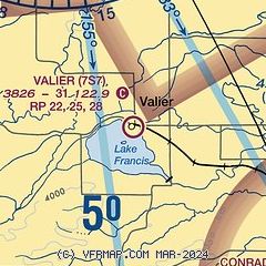
|
| Airport distance calculator |
|---|
|
|
| Sunrise and sunset |
|---|
|
Times for 26-Jan-2026
| | Local
(UTC-7) | | Zulu
(UTC) |
|---|
| Morning civil twilight | | 07:32 | | 14:32 |
| Sunrise | | 08:06 | | 15:06 |
| Sunset | | 17:17 | | 00:17 |
| Evening civil twilight | | 17:52 | | 00:52 |
|
| Current date and time |
|---|
| Zulu (UTC) | 26-Jan-2026 23:25:03 |
|---|
| Local (UTC-7) | 26-Jan-2026 16:25:03 |
|---|
|
| METAR |
|---|
KCTB
19nm N | 262256Z AUTO 26023G33KT 10SM CLR 02/M10 A2998 RMK AO2 PK WND 27034/2245 SLP181 T00171100
|
KSBX
21nm NE | 262255Z AUTO 10003KT 10SM CLR M04/M08 A3005 RMK AO2
|
|
| TAF |
|---|
KCTB
19nm N | 261720Z 2618/2718 34011G19KT P6SM FEW090 SCT120 FM262000 26015G25KT P6SM BKN120 FM270000 25010KT P6SM BKN090
|
|
| NOTAMs |
|---|
NOTAMs are issued by the DoD/FAA and will open in a separate window not controlled by AirNav.
|
|

