FAA INFORMATION EFFECTIVE 25 DECEMBER 2025
Location
| FAA Identifier: | 9F9 |
| Lat/Long: | 32-37-37.3000N 097-21-14.4250W
32-37.621667N 097-21.240417W
32.6270278,-97.3540069
(estimated) |
| Elevation: | 762 ft. / 232 m (estimated) |
| Variation: | 07E (1985) |
| From city: | 8 miles S of FORT WORTH, TX |
| Time zone: | UTC -6 (UTC -5 during Daylight Saving Time) |
| Zip code: | 76134 |
Airport Operations
| Airport use: | Open to the public |
| Activation date: | 02/1967 |
| Control tower: | no |
| ARTCC: | FORT WORTH CENTER |
| FSS: | FORT WORTH FLIGHT SERVICE STATION |
| NOTAMs facility: | FTW (NOTAM-D service available) |
| Attendance: | 0900-1700 |
| Pattern altitude: | 1562 ft. MSL |
| Wind indicator: | yes |
| Segmented circle: | yes |
| Lights: | LIRL RWY 17/35 CALL AHEAD, 817-293-0510 M-F 09:00-17:00. |
| Landing fee: | yes, LNDG FEE FOR ALL TSNT ACFT. |
Airport Communications
| CTAF/UNICOM: | 122.8 |
| WX AWOS-3PT at FWS (4 nm SE): | 120.025 (817-426-4172) |
| WX ASOS at FTW (12 nm N): | PHONE 817-740-3346 |
| WX ASOS at GKY (13 nm E): | 127.375 (817-557-0251) |
| WX AWOS-3P at GPM (16 nm E): | 118.475 (972-606-1433) |
| WX AWOS-3 at CPT (17 nm S): | 119.525 (817-641-4135) |
Nearby radio navigation aids
| VOR radial/distance | | VOR name | | Freq | | Var |
|---|
| FUZr203/18.0 | | RANGER VORTAC | | 115.70 | | 06E |
| TTTr221/21.5 | | MAVERICK VOR/DME | | 113.10 | | 06E |
| CVEr229/27.7 | | COWBOY VOR/DME | | 116.20 | | 06E |
| MQPr091/33.0 | | MILLSAP VORTAC | | 117.70 | | 09E |
Airport Services
| Fuel available: | 100LL |
| Parking: | tiedowns |
| Airframe service: | MINOR |
| Powerplant service: | MINOR |
| Bottled oxygen: | NONE |
| Bulk oxygen: | NONE |
Runway Information
Runway 17/35
| Dimensions: | 3375 x 30 ft. / 1029 x 9 m |
| Surface: | concrete, in excellent condition |
| Runway edge lights: | non-standard
NSTD LIRL - SINGLE WHITE THR LGT EACH SIDE, NSTD 15 FT FM RWY EDGE. 2766 FT USBL AT NGT. RWY 35 THR 609 FT AT NGT. |
| RUNWAY 17 | | RUNWAY 35 |
| Latitude: | 32-37.900000N | | 32-37.343333N |
| Longitude: | 097-21.230833W | | 097-21.250000W |
| Elevation: | 760.0 ft. | | 762.0 ft. |
| Traffic pattern: | right | | left |
| Runway heading: | 175 magnetic, 182 true | | 355 magnetic, 002 true |
| Displaced threshold: | no | | 175 ft. |
| Markings: | basic, in fair condition | | basic, in fair condition |
| Obstructions: | 28 ft. rr, 201 ft. from runway, 75 ft. right of centerline
27 FT RAILROAD 59 FT R & 30 PLINE 123 FT R. | | 25 ft. rr, 201 ft. from runway, 100 ft. left of centerline
27 FT RR, 0-199 FT DSTC, 85 FT L, 15 FT RD, 90 FT DSTC, 125 FT L/R, 12 FT BLDG, 55 FT DSTC, 53 FT R. |
Airport Ownership and Management from official FAA records
| Ownership: | Privately-owned |
| Owner: | CONNIE AND RON GYURE
2300 CUMMINGHAM STREET
FORT WORTH, TX 76134
Phone 817-293-0510 |
| Manager: | CONNIE AND RON GYURE
2300 CUNNINGHAM ST
FORT WORTH, TX 76134
Phone 817-293-0510 |
Additional Remarks
| - | RWY 17/35 7 FT WALL 76 FT EAST OF CNTRLN PARALLEL TO RWY 730 FT N END OF RWY. |
| - | ARPT CLSD TO TSNT ACFT EXCP 2 HRS PPR CALL 817-293-0510. |
| - | FOR CD CTC REGIONAL APCH AT 972-615-2799. |
| - | WINDSOCK MAY BE UNREL DUE TO PROXIMITY OF TREES. |
Instrument Procedures
There are no published instrument procedures at 9F9.
Some nearby airports with instrument procedures:
KFWS - Fort Worth Spinks Airport (4 nm SE)
KNFW - Fort Worth Naval Air Station JRB (Carswell Field) Airport (10 nm NW)
KFTW - Fort Worth Meacham International Airport (12 nm N)
50F - Bourland Field Airport (12 nm W)
KGKY - Arlington Municipal Airport (13 nm E)
KGPM - Grand Prairie Municipal Airport (16 nm E)
KCPT - Cleburne Regional Airport (17 nm S)
KWEA - Parker County Airport (18 nm NW)
|
|

Road maps at:
MapQuest
Bing
Google
| Aerial photo |
|---|
WARNING: Photo may not be current or correct
 Photo by Bill Richardson
Photo taken 08-Sep-2013
looking south.
Photo by Bill Richardson
Photo taken 08-Sep-2013
looking south.
Do you have a better or more recent aerial photo of Sycamore Strip Airport that you would like to share? If so, please send us your photo.
|
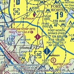
| Sectional chart |
|---|
|
| Airport distance calculator |
|---|
|
|
| Sunrise and sunset |
|---|
|
Times for 29-Dec-2025
| | Local
(UTC-6) | | Zulu
(UTC) |
|---|
| Morning civil twilight | | 07:05 | | 13:05 |
| Sunrise | | 07:32 | | 13:32 |
| Sunset | | 17:31 | | 23:31 |
| Evening civil twilight | | 17:58 | | 23:58 |
|
| Current date and time |
|---|
| Zulu (UTC) | 30-Dec-2025 03:00:27 |
|---|
| Local (UTC-6) | 29-Dec-2025 21:00:27 |
|---|
|
| METAR |
|---|
KFWS
5nm SE | 300047Z 35015KT 10SM CLR 05/M09 A3053
|
KNFW
10nm NW | 300252Z 32011KT 10SM BKN200 BKN250 05/M08 A3055 RMK AO2 SLP325 T00501083 53009 $
|
KFTW
12nm N | 300253Z 31008KT 10SM CLR 04/M09 A3053 RMK AO2 SLP343 T00441089 53009 $
|
KGKY
13nm E | 300253Z AUTO 31009KT 10SM CLR 06/M09 A3054 RMK AO2 SLP343 T00561094 53011
|
KGPM
16nm E | 300235Z AUTO 35003KT 10SM CLR 06/M10 A3055 RMK AO2 T00551096
|
KCPT
17nm S | 300235Z AUTO 32008KT 10SM OVC200 04/M10 A3048 RMK AO2 T00381100 $
|
|
| TAF |
|---|
KNFW
10nm NW | 2923/3023 35008KT 9999 SCT180 BKN250 QNH3046INS FM302100 24005KT 9999 SCT250 QNH3035INS AUTOMATED SENSOR METWATCH 3005 TIL 3012 TX10/3022Z TN01/3013Z FN20048
|
KFTW
12nm N | 292100Z 2921/3018 32015G25KT P6SM BKN180 FM300000 33007KT P6SM BKN200
|
KGKY
13nm E | 292100Z 2921/3018 32015KT P6SM BKN180 FM300000 33007KT P6SM BKN200
|
|
| NOTAMs |
|---|
NOTAMs are issued by the DoD/FAA and will open in a separate window not controlled by AirNav.
|
|


