FAA INFORMATION EFFECTIVE 11 JUNE 2026
Location
| FAA Identifier: | 9G3 |
| Lat/Long: | 43-01-15.9464N 078-28-57.4795W
43-01.265773N 078-28.957992W
43.0210962,-78.4826332
(estimated) |
| Elevation: | 839.7 ft. / 255.9 m (surveyed) |
| Variation: | 11W (1990) |
| From city: | 1 mile E of AKRON, NY |
| Time zone: | UTC -4 (UTC -5 during Standard Time) |
| Zip code: | 14001 |
Airport Operations
| Airport use: | Open to the public |
| Activation date: | 02/1961 |
| Control tower: | no |
| ARTCC: | CLEVELAND CENTER |
| FSS: | BUFFALO FLIGHT SERVICE STATION |
| NOTAMs facility: | BUF (NOTAM-D service available) |
| Attendance: | UNATND
FOR ATNDTC CALL 716-864-5004, ALLEN KIDDER. |
| Wind indicator: | yes |
| Segmented circle: | no |
| Lights: | ACTVT PAPI RWY 07 & 25; REIL RWY 25; MIRL RWY 07/25 - CTAF. |
| Beacon: | white-green (lighted land airport)
Operates sunset to sunrise. |
Airport Communications
| CTAF/UNICOM: | 122.725 |
| BUFFALO APPROACH: | 126.15 |
| BUFFALO DEPARTURE: | 126.15 |
| WX ASOS at BUF (12 nm SW): | PHONE 716-587-0517 |
| WX AWOS-3PT at GVQ (14 nm E): | 127.525 (585-343-6369) |
Nearby radio navigation aids
| VOR radial/distance | | VOR name | | Freq | | Var |
|---|
| GEEr298/34.8 | | GENESEO VOR/DME | | 108.20 | | 09W |
| ROCr273/36.0 | | ROCHESTER VOR/DME | | 110.00 | | 12W |
| NDB name | | Hdg/Dist | | Freq | | Var | | ID |
|---|
| KLUMP | | 089/7.5 | | 231 | | 09W | | BU | -... ..- |
Airport Services
| Fuel available: | 100LL
100LL:FUEL 24 HR SELF SVC. |
| Parking: | tiedowns |
| Airframe service: | NONE |
| Powerplant service: | NONE |
| Bottled oxygen: | NONE |
| Bulk oxygen: | NONE |
Runway Information
Runway 7/25
| Dimensions: | 3268 x 75 ft. / 996 x 23 m |
| Surface: | asphalt, in fair condition |
| Weight bearing capacity: | |
| Runway edge lights: | medium intensity |
| RUNWAY 7 | | RUNWAY 25 |
| Latitude: | 43-01.129762N | | 43-01.401785N |
| Longitude: | 078-29.274225W | | 078-28.641758W |
| Elevation: | 829.8 ft. | | 839.7 ft. |
| Traffic pattern: | left | | left |
| Runway heading: | 071 magnetic, 060 true | | 251 magnetic, 240 true |
| Markings: | nonprecision, in fair condition | | nonprecision, in fair condition |
| Visual slope indicator: | 2-light PAPI on left (4.00 degrees glide path)
UNUSBL BYD 7 DEGS RIGHT OF CNTRLN. | | 2-light PAPI on left (4.00 degrees glide path) |
| Runway end identifier lights: | no | | yes |
| Touchdown point: | yes, no lights | | yes, no lights |
| Obstructions: | 50 ft. trees, 201 ft. from runway, 185 ft. right of centerline
8 FT FENCE: 54 FT DSTC, 220 FT R. | | 40 ft. trees, 240 ft. from runway, 240 ft. left of centerline, 1:1 slope to clear
8 FT SIGN: 11 FT DSTC, 249 FT R; 8 FT FENCE 130-199 FT D. |
Airport Ownership and Management from official FAA records
| Ownership: | Privately-owned |
| Owner: | CHRISTIAN AIRMEN INC.
PO BOX 126
AKRON, NY 14001
Phone 716-542-4607 |
| Manager: | PETER TREICHLER
BOX 126, JOHN ST.
AKRON, NY 14001
Phone 716-542-4607 |
Additional Remarks
| - | PARL TWY LGTD AND 35 FT WIDE. |
| - | RWY 25 NOISE ABATEMENT - MNTN RWY HDG TIL 3/4 MI BYD DEP END RWY 25 BFR TURNING. |
| - | FOR CD CTC CLEVELAND ARTCC AT 440-774-0490. |
Instrument Procedures
NOTE: All procedures below are presented as PDF files. If you need a reader for these files, you should download the free Adobe Reader.NOT FOR NAVIGATION. Please procure official charts for flight.
FAA instrument procedures published for use from 11 June 2026 at 0901Z to 09 July 2026 at 0900z.
IAPs - Instrument Approach Procedures |
|---|
| RNAV (GPS) RWY 07 | |
download (201KB) |
| RNAV (GPS) RWY 25 | |
download (184KB) |
| NOTE: Special Take-Off Minimums/Departure Procedures apply | |
download (438KB) |
Other nearby airports with instrument procedures:
KBQR - Buffalo-Lancaster Regional Airport (8 nm SW)
KBUF - Buffalo Niagara International Airport (12 nm SW)
9G6 - Pine Hill Airport (13 nm NE)
KGVQ - Genesee County Airport (14 nm E)
9G0 - Buffalo Airfield (14 nm SW)
|
|

Road maps at:
MapQuest
Bing
Google
| Aerial photo |
|---|
WARNING: Photo may not be current or correct

Do you have a better or more recent aerial photo of Akron Airport/Jesson Field that you would like to share? If so, please send us your photo.
|
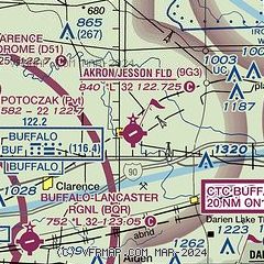
| Sectional chart |
|---|
|
CAUTION: Diagram may not be current

| Airport distance calculator |
|---|
|
|
| Sunrise and sunset |
|---|
|
Times for 15-Jun-2026
| | Local
(UTC-4) | | Zulu
(UTC) |
|---|
| Morning civil twilight | | 05:00 | | 09:00 |
| Sunrise | | 05:35 | | 09:35 |
| Sunset | | 20:54 | | 00:54 |
| Evening civil twilight | | 21:29 | | 01:29 |
|
| Current date and time |
|---|
| Zulu (UTC) | 15-Jun-2026 17:02:40 |
|---|
| Local (UTC-4) | 15-Jun-2026 13:02:40 |
|---|
|
| METAR |
|---|
KBUF
12nm SW | 151654Z 28009G16KT 10SM BKN037 BKN230 15/07 A2986 RMK AO2 SLP113 T01500072 $
|
KGVQ
14nm E | 151656Z AUTO 27012KT 10SM BKN033 15/06 A2985 RMK AO2 SLP108 T01500061
|
KIAG
21nm W | 151653Z 29009G18KT 10SM CLR 16/08 A2986 RMK AO2 SLP114 T01610078 $
|
|
| TAF |
|---|
KBUF
12nm SW | 151352Z 1514/1612 29012G20KT P6SM SCT030 BKN050 FM152000 25012G20KT P6SM BKN100 FM160100 23005KT P6SM SKC FM160600 19006KT P6SM FEW250
|
|
| NOTAMs |
|---|
NOTAMs are issued by the DoD/FAA and will open in a separate window not controlled by AirNav.
|
|


