FAA INFORMATION EFFECTIVE 11 JUNE 2026
Location
| FAA Identifier: | 9V9 |
| Lat/Long: | 43-45-58.0935N 099-19-16.4251W
43-45.968225N 099-19.273752W
43.7661371,-99.3212292
(estimated) |
| Elevation: | 1696.3 ft. / 517 m (estimated) |
| Variation: | 05E (2020) |
| From city: | 3 miles S of CHAMBERLAIN, SD |
| Time zone: | UTC -5 (UTC -6 during Standard Time) |
| Zip code: | 57325 |
Airport Operations
| Airport use: | Open to the public |
| Activation date: | 05/1981 |
| Control tower: | no |
| ARTCC: | MINNEAPOLIS CENTER |
| FSS: | HURON FLIGHT SERVICE STATION |
| NOTAMs facility: | 9V9 (NOTAM-D service available) |
| Attendance: | CONTINUOUS |
| Wind indicator: | lighted |
| Segmented circle: | yes |
| Lights: | MIRL RY 13/31 PRESET ON LOW INTST, TO INCR INTST & ACTVT PAPI RYS 13 & 31 - CTAF. |
| Beacon: | white-green (lighted land airport)
Operates sunset to sunrise. |
Airport Communications
| CTAF/UNICOM: | 122.8 |
| WX AWOS-3P: | 118.025 (605-234-1437) |
- APCH/DEP SVC PRVDD BY MINNEAPOLIS ARTCC ON FREQS 125.1/269.1 (PIERRE RCAG).
Airport Services
| Fuel available: | 100LL JET-A
100LL:FUEL AVBL 24 HRS WITH CREDIT CARD. |
| Parking: | hangars and tiedowns |
| Airframe service: | MINOR |
| Powerplant service: | MINOR |
Runway Information
Runway 13/31
| Dimensions: | 4299 x 75 ft. / 1310 x 23 m |
| Surface: | asphalt, in fair condition |
| Weight bearing capacity: | |
| Runway edge lights: | medium intensity |
| RUNWAY 13 | | RUNWAY 31 |
| Latitude: | 43-46.217163N | | 43-45.667647N |
| Longitude: | 099-19.584610W | | 099-18.969678W |
| Elevation: | 1696.3 ft. | | 1678.1 ft. |
| Traffic pattern: | left | | left |
| Runway heading: | 136 magnetic, 141 true | | 316 magnetic, 321 true |
| Markings: | nonprecision, in good condition | | nonprecision, in good condition |
| Visual slope indicator: | 2-light PAPI on left (3.00 degrees glide path) | | 2-light PAPI on left (3.00 degrees glide path) |
| Runway end identifier lights: | no | | no |
| Touchdown point: | yes, no lights | | yes, no lights |
| Obstructions: | 64 ft. tree, 1539 ft. from runway, 415 ft. left of centerline, 20:1 slope to clear | | none |
Runway 18/36
| Dimensions: | 3403 x 150 ft. / 1037 x 46 m |
| Surface: | turf, in good condition |
| Runway edge markings: | MKD WITH WHITE/BLACK TIPPED MKR CONES. |
| RUNWAY 18 | | RUNWAY 36 |
| Latitude: | 43-46.278752N | | 43-45.722935N |
| Longitude: | 099-19.221735W | | 099-19.317198W |
| Elevation: | 1696.0 ft. | | 1680.0 ft. |
| Traffic pattern: | left | | left |
| Runway heading: | 182 magnetic, 187 true | | 002 magnetic, 007 true |
| Touchdown point: | yes, no lights | | yes, no lights |
| Obstructions: | 46 ft. pole, 1000 ft. from runway, 21:1 slope to clear | | none |
Airport Ownership and Management from official FAA records
| Ownership: | Publicly-owned |
| Owner: | CITY OF CHAMBERLAIN
715 N. MAIN ST.
CHAMBERLAIN, SD 57325
Phone 605-680-9935 |
| Manager: | DUSTEN HRABE
101 AIRPORT ROAD
CHAMBERLAIN, SD 57325
Phone 605-680-9935 |
Additional Remarks
| - | WATERFOWL ON & INVOF ARPT. |
| - | GCO AVBL ON FREQ 121.725 ( 4 CLICKS TO MINNEAPOLIS CENTER AND 6 CLIKCS TO FLIGHT SERVICES) |
| - | FOR CD IF UNA VIA GCO CTC MINNEAPOLIS ARTCC AT 651-463-5588. |
Instrument Procedures
NOTE: All procedures below are presented as PDF files. If you need a reader for these files, you should download the free Adobe Reader.NOT FOR NAVIGATION. Please procure official charts for flight.
FAA instrument procedures published for use from 11 June 2026 at 0901Z to 09 July 2026 at 0900z.
IAPs - Instrument Approach Procedures |
|---|
| RNAV (GPS) RWY 13 **CHANGED** | |
download (205KB) |
| RNAV (GPS) RWY 31 **CHANGED** | |
download (210KB) |
| NOTE: Special Take-Off Minimums/Departure Procedures apply | |
download (156KB) |
Other nearby airports with instrument procedures:
KICR - Winner Regional Airport (32 nm SW)
9D1 - Gregory Municipal Airport/Flynn Field (33 nm S)
4X4 - Wessington Springs Airport (38 nm NE)
9D0 - Highmore Municipal Airport (47 nm N)
KMKA - Miller Municipal Airport (48 nm N)
|
|

Road maps at:
MapQuest
Bing
Google
| Aerial photo |
|---|
WARNING: Photo may not be current or correct
 Photo by Steve Hamilton
Photo taken 23-Apr-2006
Photo by Steve Hamilton
Photo taken 23-Apr-2006
Do you have a better or more recent aerial photo of Chamberlain Municipal Airport that you would like to share? If so, please send us your photo.
|
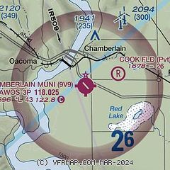
| Sectional chart |
|---|
|
| Airport distance calculator |
|---|
|
|
| Sunrise and sunset |
|---|
|
Times for 23-Jun-2026
| | Local
(UTC-5) | | Zulu
(UTC) |
|---|
| Morning civil twilight | | 05:21 | | 10:21 |
| Sunrise | | 05:57 | | 10:57 |
| Sunset | | 21:22 | | 02:22 |
| Evening civil twilight | | 21:58 | | 02:58 |
|
| Current date and time |
|---|
| Zulu (UTC) | 23-Jun-2026 14:01:51 |
|---|
| Local (UTC-5) | 23-Jun-2026 09:01:51 |
|---|
|
| METAR |
|---|
| K9V9 | 231355Z AUTO 24003KT 10SM SCT029 SCT035 BKN044 19/19 A3016 RMK AO2 P0001 T01880188
|
|
| NOTAMs |
|---|
NOTAMs are issued by the DoD/FAA and will open in a separate window not controlled by AirNav.
|
|

