FAA INFORMATION EFFECTIVE 30 OCTOBER 2025
Location
| FAA Identifier: | A39 |
| Lat/Long: | 32-59-25.9750N 111-55-08.0450W
32-59.432917N 111-55.134083W
32.9905486,-111.9189014
(estimated) |
| Elevation: | 1307 ft. / 398 m (estimated) |
| Variation: | 12E (1995) |
| From city: | 5 miles ESE of MARICOPA, AZ |
| Time zone: | UTC -7 (year round; does not observe DST) |
| Zip code: | 85239 |
Airport Operations
| Airport use: | Open to the public |
| Activation date: | 05/1999 |
| Control tower: | no |
| ARTCC: | ALBUQUERQUE CENTER |
| FSS: | PRESCOTT FLIGHT SERVICE STATION |
| NOTAMs facility: | PRC (NOTAM-D service available) |
| Attendance: | MON-SAT 0800-1700 |
| Wind indicator: | yes |
| Segmented circle: | yes |
| Lights: | ACTIVATE MIRL RWY. 4-22 - CTAF. |
| Beacon: | white-green (lighted land airport)
Operates sunset to sunrise. |
Airport Communications
| CTAF: | 122.9 |
| WX AWOS-3: | 126.900 (520-568-7704) |
| WX AWOS-3PT at CGZ (8 nm E): | 132.175 (520-836-3392) |
| WX AWOS-3PT at CHD (18 nm N): | PHONE 480-814-9952 |
Nearby radio navigation aids
| VOR radial/distance | | VOR name | | Freq | | Var |
|---|
| TFDr343/6.3 | | STANFIELD VORTAC | | 114.80 | | 12E |
| IWAr203/23.1 | | WILLIE VORTAC | | 113.30 | | 13E |
| PXRr162/26.7 | | PHOENIX VORTAC | | 115.60 | | 12E |
| GBNr073/38.1 | | GILA BEND VORTAC | | 116.60 | | 14E |
Airport Services
| Fuel available: | 100LL
100LL:AVAILABLE 24 HRS, SELF-SERVE WITH MAJOR CREDIT CARD. , EXCEPT AMERICAN EXPRESS. |
| Parking: | tiedowns |
Runway Information
Runway 4/22
| Dimensions: | 4751 x 50 ft. / 1448 x 15 m |
| Surface: | asphalt, in good condition |
| Runway edge lights: | medium intensity |
| RUNWAY 4 | | RUNWAY 22 |
| Latitude: | 32-59.170500N | | 32-59.695333N |
| Longitude: | 111-55.479167W | | 111-54.789000W |
| Elevation: | 1275.0 ft. | | 1306.0 ft. |
| Traffic pattern: | left | | left |
| Runway heading: | 036 magnetic, 048 true | | 216 magnetic, 228 true |
| Displaced threshold: | no | | 290 ft. |
| Declared distances: | TORA:4751 TODA:4751 ASDA:4751 LDA:4751 | | TORA:4751 TODA:4751 ASDA:4751 LDA:4461 |
| Markings: | nonprecision, in good condition | | nonprecision, in good condition |
| Obstructions: | none | | 8 ft. fence, lighted, 240 ft. from runway, 128 ft. left of centerline, 5:1 slope to clear
37:1 CLNC SLP TO RWY 22 DSPLCD THLD DUE TO 15 FT ROADWAY 565 FT FROM DSPLCD THLD, 175 FT LEFT OF CNTRLN. |
Airport Ownership and Management from official FAA records
| Ownership: | Publicly-owned |
| Owner: | AK CHIN INDIAN COMMUNITY
42507 WEST PETERS AND NALL, BOX 1
MARICOPA, AZ 85138
Phone 520-568-1000 |
| Manager: | TIMOTHY COSTELLO
32514 W. BUD RD
MARICOPA, AZ 85138
Phone 520-568-1683
AIRPORT MANAGER - ALT. NO. 520-709-8914. |
Additional Remarks
| - | ANTENNA ESTIMATED TO BE APPROXIMATELY 200 FT - 300 FT OR MORE ABOVE GROUND LEVEL, APPROXIMATELY 3 MILES WNW FM WEST BOUNDARY OF AK-CHIN RGNL ARPT. |
| - | 45 FT PLINE 2 MILES SSW AND 2 MILES NE OF ARPT. |
| - | RY 22+8 FT. FENCE 116 FT FM EOR, HIGHWAY 166 FT FM EOR. OR. |
| - | ULTRALIGHT ACTIVITY INVOF ARPT. |
| - | AWOS FREQ. 126.9, LAND LINE 520-568-7704. |
| - | FOR CD CTC ALBUQUERQUE ARTCC AT 505-856-4861. |
Instrument Procedures
There are no published instrument procedures at A39.
Some nearby airports with instrument procedures:
KCGZ - Casa Grande Municipal Airport (8 nm E)
KCHD - Chandler Municipal Airport (18 nm N)
P19 - Stellar Airpark (18 nm N)
KIWA - Mesa Gateway Airport (23 nm NE)
P08 - Coolidge Municipal Airport (25 nm E)
|
|

Road maps at:
MapQuest
Bing
Google
| Aerial photo |
|---|
WARNING: Photo may not be current or correct
 Photo by Michael Berry
Taken early October 2012
looking northeast.
Photo by Michael Berry
Taken early October 2012
looking northeast.
Do you have a better or more recent aerial photo of Ak-Chin Regional Airport that you would like to share? If so, please send us your photo.
|
| Sectional chart |
|---|
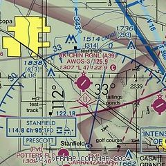
|
| Airport distance calculator |
|---|
|
|
| Sunrise and sunset |
|---|
|
Times for 11-Nov-2025
| | Local
(UTC-7) | | Zulu
(UTC) |
|---|
| Morning civil twilight | | 06:30 | | 13:30 |
| Sunrise | | 06:56 | | 13:56 |
| Sunset | | 17:28 | | 00:28 |
| Evening civil twilight | | 17:54 | | 00:54 |
|
| Current date and time |
|---|
| Zulu (UTC) | 11-Nov-2025 12:30:29 |
|---|
| Local (UTC-7) | 11-Nov-2025 05:30:29 |
|---|
|
| METAR |
|---|
| KA39 | 111215Z AUTO 12004KT 10SM CLR 10/00 A3014 RMK AO2
|
KCGZ
8nm E | 111156Z AUTO 00000KT 10SM CLR 13/M02 A3013 RMK AO2 SLP193 6//// 7//// T01331022 10217 20128 PNO $
|
KCHD
17nm N | 111215Z AUTO 07003KT 10SM CLR 13/04 A3011 RMK AO2 T01300043 $
|
|
| TAF |
|---|
KIWA
23nm NE | 111122Z 1112/1212 12005KT P6SM SCT250 FM111900 29004KT P6SM SCT250 FM120300 12007KT P6SM FEW200 BKN250
|
KPHX
27nm N | 111122Z 1112/1218 11005KT P6SM SCT250 FM112100 28004KT P6SM SCT250 FM120600 10005KT P6SM FEW200 BKN250
|
|
| NOTAMs |
|---|
NOTAMs are issued by the DoD/FAA and will open in a separate window not controlled by AirNav.
|
|


