FAA INFORMATION EFFECTIVE 14 MAY 2026
Location
| FAA Identifier: | AFF |
| Lat/Long: | 38-58-24.2091N 104-49-12.1178W
38-58.403485N 104-49.201963W
38.9733914,-104.8200327
(estimated) |
| Elevation: | 6576 ft. / 2004.4 m (surveyed) |
| Variation: | 11E (1985) |
| From city: | 10 miles N of COLORADO SPRINGS, CO |
| Time zone: | UTC -6 (UTC -7 during Standard Time) |
| Zip code: | 80840 |
Airport Operations
| Airport use: | Private use. Permission required prior to landing |
| Activation date: | 01/1943 |
| Control tower: | yes |
| ARTCC: | DENVER CENTER |
| FSS: | DENVER FLIGHT SERVICE STATION |
| NOTAMs facility: | KAFF (NOTAM-D service available) |
| Attendance: | OCT 1 TO FEB 28/29/FRI/SR OR 1345Z++, ALL SAT 1430Z++ TO 2130Z++, MAR 1 TO SEP 30 MON-THUR SR OR 1345Z++
CLSD SUN & FED HOL.
CLSD SUN & FED HOL.
(WHICHEVER IS LATER) TO SS OR 0200Z++ (WHICHEVER IS EARLIER).
(WHICHEVER IS LATER) TO SS OR 0300Z++ (WHICHEVER IS EARLIER).
(WHEN NEC TO SUPPORT 306 FTG FLT OPS); 306TH FTG SUMMER OPS MON-FRI 1300-0200Z++, SAT 1430-2130Z++ (ONLY WHEN NEC TO SUPPORT 306 FTG FLT OPS), CLSD SUN AND FEDERAL HOL. |
| Wind indicator: | yes |
| Segmented circle: | no |
Airport Communications
| CTAF: | 124.15 |
| ATIS: | 128.525 269.375 |
| ACADEMY GROUND: | 118.125 [OPR SR OR 1245Z++ (WHICHEVER IS LATER) TO SS MON-FRI, 1430Z++ TO 2130Z++ SAT, EXCLUDING SUN AND HOL.] |
| ACADEMY TOWER: | 124.15 319.25 [OPR SR OR 1245Z++ (WHICHEVER IS LATER) TO SS MON-FRI, 1430Z++ TO 2130Z++ SAT, EXCLUDING SUN AND HOL.] |
| EMERG: | 121.5 243.0 |
| OPS: | 127.15 ;SKYTRAIN |
| WX ASOS at COS (11 nm SE): | 125.0 (719-694-7502) |
| WX AWOS-3PT at FLY (12 nm E): | 118.450 (719-683-5371) |
| WX AWOS-3 at FCS (18 nm S): | 125.0 (719-637-9696) |
Nearby radio navigation aids
| VOR radial/distance | | VOR name | | Freq | | Var |
|---|
| BRKr273/8.9 | | BLACK FOREST VOR/DME | | 112.50 | | 08E |
| FCSr338/17.8 | | BUTTS VOR/DME | | 108.80 | | 12E |
| NDB name | | Hdg/Dist | | Freq | | Var | | ID |
|---|
| IRONHORSE | | 342/18.0 | | 335 | | 08E | | IHS | .. .... ... |
Airport Services
| Parking: | hangars |
| Airframe service: | NONE |
| Powerplant service: | NONE |
| Bottled oxygen: | NONE |
| Bulk oxygen: | NONE |
Runway Information
Runway 16C/34C
| Dimensions: | 4501 x 75 ft. / 1372 x 23 m |
| Surface: | asphalt, in good condition |
| Weight bearing capacity: | |
| RUNWAY 16C | | RUNWAY 34C |
| Latitude: | 38-58.714833N | | 38-57.985667N |
| Longitude: | 104-49.352000W | | 104-49.180167W |
| Elevation: | 6526.0 ft. | | 6505.0 ft. |
| Traffic pattern: | left | | left |
| Runway heading: | 159 magnetic, 170 true | | 339 magnetic, 350 true |
| Markings: | numbers only, in good condition | | numbers only, in good condition |
Runway 16R/34L
| Dimensions: | 4500 x 40 ft. / 1372 x 12 m |
| Surface: | asphalt |
| Weight bearing capacity: | |
| RUNWAY 16R | | RUNWAY 34L |
| Latitude: | 38-58.707833N | | 38-57.979167N |
| Longitude: | 104-49.405000W | | 104-49.231667W |
| Elevation: | 6515.0 ft. | | 6502.0 ft. |
| Traffic pattern: | left | | left |
| Runway heading: | 158 magnetic, 169 true | | 338 magnetic, 349 true |
| Markings: | numbers only | | numbers only |
| Runway end identifier lights: | no | | no |
Runway 16L/34R
| Dimensions: | 3513 x 75 ft. / 1071 x 23 m |
| Surface: | asphalt, in good condition |
| Weight bearing capacity: | |
| RUNWAY 16L | | RUNWAY 34R |
| Latitude: | 38-58.736167N | | 38-58.167167N |
| Longitude: | 104-49.143167W | | 104-49.008333W |
| Elevation: | 6545.0 ft. | | 6534.0 ft. |
| Traffic pattern: | left | | left |
| Runway heading: | 159 magnetic, 170 true | | 339 magnetic, 350 true |
| Markings: | numbers only, in good condition | | numbers only, in good condition |
| Runway end identifier lights: | no | | no |
Runway 9/27
| Dimensions: | 2493 x 75 ft. / 760 x 23 m |
| Surface: | asphalt, in good condition |
| Weight bearing capacity: | |
| RUNWAY 9 | | RUNWAY 27 |
| Latitude: | 38-58.560667N | | 38-58.519000N |
| Longitude: | 104-49.321167W | | 104-48.797667W |
| Elevation: | 6528.0 ft. | | 6576.0 ft. |
| Traffic pattern: | left | | left |
| Runway heading: | 085 magnetic, 096 true | | 265 magnetic, 276 true |
| Markings: | numbers only, in good condition | | numbers only, in good condition |
Airport Ownership and Management from official FAA records
| Ownership: | U.S. Air Force |
| Owner: | USAF
HQS USAF ACADEMY
COLORADO SPRINGS, CO 80901 |
| Manager: | CHIEF AIRFIELD MANAGEMENT
HQS USAF ACADEMY
COLORADO SPRINGS, CO 80901 |
Additional Remarks
| - | CAUTION: USE CTN FOR UAS OPS 3-6 NM NW SFC-8500 FT MSL OVER USAF ACADEMY PROPERTY. |
| - | FUEL-A++(MIL) |
| - | COMSEC STOR UNAVBL. |
| - | CAUTION: NUMEROUS NSTD MRKS EXIST ON AFLD. |
| - | SEE SPECIAL NOTICE US AIR FORCE ACADEMY VOLUME FLT TRNG AREAS FOR ADDN INFO. |
| - | RSTD: AIRFIELD OFFL BUS ONLY. PPR MUST BE COORD 72 HR IN ADVANCE WITH AFLD MGMT, DSN: 333-2526, C:719-333-2526. |
| - | CAUTION: CEILING MAY BE LOWER TO N, E, AND W DUE TO RISING TERRAIN. HI DENSITY VFR STU PILOT TRNG, GLDR TRNG AND PRCHT OPS FR SFC-17500 FT MSL WI 5 NM OF AFLD. USE CAUTION FOR UAS OPS 3-6 NM NW SFC-8500 FT MSL OVR USAF ACADEMY PROPERTY. AERODROME RWY CC NOT REPORTED. |
| - | MISC: FULL SVC WX STN OPR H24 WITH AUGMENTED AN/FMQ-19 IN USE. BACKUP WX BRIEFING SVC FR 25 OWS, DAVIS MONTHAN AFB, AZ, DSN 228-6589 OR C520-228-6598. |
| - | CAUTION: MULT CRANES WI 3 NMR OF KAFF IN NE QUAD UP TO 250 FT AGL (INTERQUEST PKWY AND I-25 AREA). |
| - | CL D ATC SVS AVAIL DUR AFLD OPR HR. CHECK AFF ATIS AND NOTAMS FOR ADDN CURRENT INFO. |
| - | CAUTION: HIGH WIND ALERT SYSTEM (HWAS) N OF RWY 09/27 AND E OF TWY A UNLGTD. |
| - | SERVICE - NO TRAN ALERT OR MAINT SVC. |
| - | RSTD: UNCTLD ACFT OPS AT DAVIS FLD STRICTLY PROHIBITED WO APVD UNCTLD OPS WAIVER; WAIVER MUST BE ON FILE WITH AMGR. |
| - | CAUTION: CRANE WITH MAX HGT OF 245 FT LOCTD BY THE US AIR FORCE ACADEMY PREPARATORY SCHOOL. EXACT LCTN 38 58 42.42N, 104 51 27.91 W. |
| - | NO MAINT OR TSNT SVC AVBL. |
Instrument Procedures
There are no published instrument procedures at KAFF.
Some nearby airports with instrument procedures:
KCOS - City of Colorado Springs Municipal Airport (11 nm SE)
KFLY - Meadow Lake Airport (12 nm E)
KFCS - Butts Army Airfield (Fort Carson) (18 nm S)
1V6 - Fremont County Airport (35 nm S)
KAPA - Centennial Airport (36 nm N)
|
|

Road maps at:
MapQuest
Bing
Google
| Aerial photo |
|---|
WARNING: Photo may not be current or correct

Do you have a better or more recent aerial photo of USAF Academy Davis Airfield that you would like to share? If so, please send us your photo.
|
| Sectional chart |
|---|
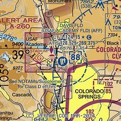
|
| Airport distance calculator |
|---|
|
|
| Sunrise and sunset |
|---|
|
Times for 18-May-2026
| | Local
(UTC-6) | | Zulu
(UTC) |
|---|
| Morning civil twilight | | 05:15 | | 11:15 |
| Sunrise | | 05:45 | | 11:45 |
| Sunset | | 20:06 | | 02:06 |
| Evening civil twilight | | 20:37 | | 02:37 |
|
| Current date and time |
|---|
| Zulu (UTC) | 18-May-2026 07:16:01 |
|---|
| Local (UTC-6) | 18-May-2026 01:16:01 |
|---|
|
| METAR |
|---|
| KAFF | 180610Z AUTO 33013KT 10SM BKN003 OVC017 07/05 A2982 RMK AO2 SLP037
|
KCOS
11nm SE | 180354Z 01014KT 10SM FEW020 FEW150 BKN250 10/04 A2981 RMK AO2 SLP042 T01000044
|
KFLY
12nm E | 180415Z AUTO 01009KT 10SM BKN055 08/04 A2985 RMK AO2 T00750040
|
KCWN
14nm S | 180555Z AUTO 34013G21KT 10SM OVC040 09/04 A2981 RMK AO2 SLP942 T00900040 10146 20090 51010 $
|
KMNH
17nm NE | 180415Z AUTO 02007KT 10SM SCT013 OVC026 06/05 A2988 RMK AO2
|
KFCS
19nm S | 180655Z AUTO 04014KT 10SM SCT027 OVC033 11/04 A2985 RMK AO2 SLP060 T01100040 402440093 $
|
|
| TAF |
|---|
KCOS
11nm SE | 180520Z 1806/1906 01011KT P6SM SCT020 BKN025 FM180800 10007KT 6SM BR OVC005 PROB30 1808/1812 4SM -SHRA FM181200 13009KT 6SM BR OVC005 FM181500 15013KT P6SM OVC010 FM181800 18015G25KT P6SM SCT030 BKN040 TEMPO 1818/1821 VRB20G30KT -TSRA BKN030CB FM182100 35025G35KT P6SM SCT030 BKN050 FM190400 35023G33KT P6SM SCT010 BKN020
|
KFCS
19nm S | 180400Z 1804/1910 36012G18KT 9999 BKN030 QNH2977INS BECMG 1806/1807 09009KT 8000 -RA BKN020 QNH2979INS TEMPO 1809/1815 14005KT 4000 BR OVC007 BECMG 1814/1815 24009KT 9999 NSW SCT080 QNH2973INS BECMG 1822/1823 35015G25KT 9999 BKN050 QNH2984INS BECMG 1905/1906 03009KT 9999 BKN050 QNH3013INS TX14/1820Z TN06/1812Z
|
|
| NOTAMs |
|---|
NOTAMs are issued by the DoD/FAA and will open in a separate window not controlled by AirNav.
|
|

