FAA INFORMATION EFFECTIVE 11 JUNE 2026
Location
| FAA Identifier: | AOH |
| Lat/Long: | 40-42-26.9207N 084-01-37.4810W
40-42.448678N 084-01.624683W
40.7074780,-84.0270781
(estimated) |
| Elevation: | 975.3 ft. / 297.3 m (surveyed) |
| Variation: | 06W (2010) |
| From city: | 5 miles SE of LIMA, OH |
| Time zone: | UTC -4 (UTC -5 during Standard Time) |
| Zip code: | 45804 |
Airport Operations
| Airport use: | Open to the public |
| Control tower: | no |
| ARTCC: | INDIANAPOLIS CENTER |
| FSS: | DAYTON FLIGHT SERVICE STATION |
| NOTAMs facility: | AOH (NOTAM-D service available) |
| Attendance: | MON-FRI 0800-1700, ALL SAT 0900-1600, ALL SUN 1300-1700
UNATNDD NEW YEARS DAY, EASTER, THANKSGIVING, & CHRISTMAS. |
| Wind indicator: | lighted |
| Segmented circle: | yes |
| Lights: | ACTVT REIL RWY 10 & 28; HIRL RWY 10/28 - CTAF. PAPI RWY 10 & 28 OPR CONSLY. |
| Beacon: | white-green (lighted land airport)
Operates sunset to sunrise. |
| Landing fee: | yes |
Airport Communications
| CTAF/UNICOM: | 122.7 |
| WX ASOS: | 128.725 (419-224-6098) |
| COLUMBUS APPROACH: | 121.825 |
| COLUMBUS DEPARTURE: | 134.45 |
| WX AWOS-3PT at AXV (18 nm SW): | 128.325 (419-753-2821) |
| WX AWOS-3 at I95 (18 nm E): | 126.4 (419-675-0781) |
| WX AWOS-3PT at OWX (20 nm N): | 120.525 (419-523-4151) |
Nearby radio navigation aids
| VOR radial/distance | | VOR name | | Freq | | Var |
|---|
| FBCr222/19.3 | | FLAG CITY VORTAC | | 108.20 | | 02W |
| RODr007/25.2 | | ROSEWOOD VORTAC | | 117.50 | | 05W |
Airport Services
| Fuel available: | 100LL JET-A1+ |
| Parking: | hangars and tiedowns |
| Airframe service: | MAJOR |
| Powerplant service: | MAJOR |
| Bottled oxygen: | HIGH |
| Bulk oxygen: | NONE |
Runway Information
Runway 10/28
| Dimensions: | 6000 x 150 ft. / 1829 x 46 m |
| Surface: | asphalt/grooved, in good condition |
| Weight bearing capacity: | |
| Runway edge lights: | high intensity |
| RUNWAY 10 | | RUNWAY 28 |
| Latitude: | 40-42.416505N | | 40-42.416297N |
| Longitude: | 084-02.341162W | | 084-01.042705W |
| Elevation: | 949.3 ft. | | 975.3 ft. |
| Traffic pattern: | left | | left |
| Runway heading: | 096 magnetic, 090 true | | 276 magnetic, 270 true |
| Markings: | nonprecision, in good condition | | precision, in good condition |
| Visual slope indicator: | 4-light PAPI on left (3.00 degrees glide path) | | 4-light PAPI on left (3.00 degrees glide path) |
| Runway end identifier lights: | yes | | yes |
| Touchdown point: | yes, no lights | | yes, no lights |
| Instrument approach: | | | ILS |
| Obstructions: | 63 ft. trees, 2140 ft. from runway, 193 ft. left of centerline, 30:1 slope to clear | | 47 ft. tree, 1685 ft. from runway, 361 ft. left of centerline, 31:1 slope to clear |
Airport Ownership and Management from official FAA records
| Ownership: | Publicly-owned |
| Owner: | ALLEN COUNTY RGNL ARPT AUTH
PO BOX 1401
LIMA, OH 45802-1401
Phone 419-227-3225 |
| Manager: | JOSH TATTRIE
700 AIRPORT DR
LIMA, OH 45804-4201
Phone 419-227-3225
CELL 567-208-1871. |
Additional Remarks
| - | FOR CD CTC COLUMBUS APCH ON FREQ, IF UNA CALL 614-338-8537. |
| - | DEER, BIRDS, & OTR WILDLIFE ON & INVOF ARPT. |
Instrument Procedures
NOTE: All procedures below are presented as PDF files. If you need a reader for these files, you should download the free Adobe Reader.NOT FOR NAVIGATION. Please procure official charts for flight.
FAA instrument procedures published for use from 11 June 2026 at 0901Z to 09 July 2026 at 0900z.
IAPs - Instrument Approach Procedures |
|---|
| ILS OR LOC RWY 28 | |
download (218KB) |
| RNAV (GPS) RWY 10 | |
download (188KB) |
| RNAV (GPS) RWY 28 | |
download (235KB) |
| NOTE: Special Alternate Minimums apply | |
download (144KB) |
| NOTE: Special Take-Off Minimums/Departure Procedures apply | |
download (164KB) |
Other nearby airports with instrument procedures:
5G7 - Bluffton Airport (13 nm NE)
KAXV - Neil Armstrong Airport (18 nm SW)
I95 - Hardin County Airport (18 nm E)
KOWX - Putnam County Airport (20 nm N)
KEDJ - Bellefontaine Regional Airport (22 nm SE)
|
|

Road maps at:
MapQuest
Bing
Google
| Aerial photo |
|---|
WARNING: Photo may not be current or correct
 Photo taken 16-Apr-2019
looking southeast.
Photo taken 16-Apr-2019
looking southeast.
Do you have a better or more recent aerial photo of Lima Allen County Airport that you would like to share? If so, please send us your photo.
|
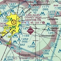
| Sectional chart |
|---|
|
| Airport distance calculator |
|---|
|
|
| Sunrise and sunset |
|---|
|
Times for 06-Jul-2026
| | Local
(UTC-4) | | Zulu
(UTC) |
|---|
| Morning civil twilight | | 05:39 | | 09:39 |
| Sunrise | | 06:12 | | 10:12 |
| Sunset | | 21:09 | | 01:09 |
| Evening civil twilight | | 21:42 | | 01:42 |
|
| Current date and time |
|---|
| Zulu (UTC) | 07-Jul-2026 00:41:57 |
|---|
| Local (UTC-4) | 06-Jul-2026 20:41:57 |
|---|
|
| METAR |
|---|
| KAOH | 062353Z AUTO 03006KT 10SM SCT013 OVC045 23/21 A3001 RMK AO2 SLP155 T02330206 10244 20228 53003
|
KAXV
18nm SW | 070015Z AUTO 01006KT 10SM OVC039 23/21 A3000 RMK AO2
|
KOWX
20nm N | 070015Z AUTO 04010KT 10SM OVC021 24/23 A3002 RMK AO2
|
|
| TAF |
|---|
KFDY
25nm NE | 061939Z 0620/0718 30007KT P6SM -RA OVC015 TEMPO 0620/0622 4SM -RA OVC015 FM062200 03011KT P6SM BKN025 FM070900 VRB05KT P6SM BKN025 FM071600 01008KT P6SM BKN050
|
|
| NOTAMs |
|---|
NOTAMs are issued by the DoD/FAA and will open in a separate window not controlled by AirNav.
|
|


