FAA INFORMATION EFFECTIVE 19 MARCH 2026
Location
| FAA Identifier: | D82 |
| Lat/Long: | 42-39-17.2540N 076-47-46.8340W
42-39.287567N 076-47.780567W
42.6547928,-76.7963428
(estimated) |
| Elevation: | 1062 ft. / 323.7 m (surveyed) |
| Variation: | 11W (1985) |
| From city: | 2 miles SE of OVID, NY |
| Time zone: | UTC -4 (UTC -5 during Standard Time) |
| Zip code: | 14521 |
Airport Operations
| Airport use: | Open to the public |
| Activation date: | 05/1950 |
| Control tower: | no |
| ARTCC: | CLEVELAND CENTER |
| FSS: | BUFFALO FLIGHT SERVICE STATION |
| NOTAMs facility: | BUF (NOTAM-D service available) |
| Attendance: | APR-NOV DAWN-DUSK, DEC-MAR ON CALL
ARPT MANAGER AT 607-869-5601. |
| Wind indicator: | yes |
| Segmented circle: | no |
Airport Communications
| CTAF/UNICOM: | 122.8 |
| WX ASOS at PEO (11 nm W): | 121.175 (315-536-4102) |
| WX AWOS-3 at 0G7 (14 nm N): | 120.0 (315-568-5362) |
| WX AWOS-3PT at ITH (18 nm SE): | 125.175 (607-257-2390) |
Nearby radio navigation aids
| VOR radial/distance | | VOR name | | Freq | | Var |
|---|
| SYRr232/40.0 | | SYRACUSE VORTAC | | 117.00 | | 11W |
| NDB name | | Hdg/Dist | | Freq | | Var | | ID |
|---|
| ALPINE | | 009/25.0 | | 245 | | 12W | | ALP | .- .-.. .--. |
Airport Services
| Fuel available: | MOGAS
MOGAS:EMERGENCY FUEL ONLY; CONTACT AIRPORT MANAGER (607)869-5601 |
| Parking: | tiedowns |
| Airframe service: | NONE |
| Powerplant service: | NONE |
| Bottled oxygen: | NONE |
| Bulk oxygen: | NONE |
Runway Information
Runway 1R/19L
| Dimensions: | 2800 x 40 ft. / 853 x 12 m |
| Surface: | asphalt, in fair condition |
| RUNWAY 1R | | RUNWAY 19L |
| Traffic pattern: | left | | left |
| Obstructions: | 49 ft. trees, 252 ft. from runway, 53 ft. right of centerline, 1:1 slope to clear
+4 FT POSTS AND +3 FT WIRE FENCE 27 FT FM THR CROSSES RWY END. | | 84 ft. trees, 1565 ft. from runway, 82 ft. right of centerline, 16:1 slope to clear
ROADWAY/DROPOFF 30 FT FROM THLD; - 15' BLW RWY 19L THLD ELEV. ALSO +7 FT TREE 61 FT FROM THLD 120 FT R. |
Runway 1L/19R
| Dimensions: | 2200 x 60 ft. / 671 x 18 m
RY 01L/19R SOFT & WET MAR-JUN. |
| Surface: | turf, in fair condition |
| RUNWAY 1L | | RUNWAY 19R |
| Traffic pattern: | left | | left |
| Obstructions: | 75 ft. trees, 89 ft. from runway, 89 ft. left of centerline, 1:1 slope to clear
+50 - +82 FT TREES X RWY THR. | | 25 ft. trees, 243 ft. from runway, 52 ft. left of centerline, 9:1 slope to clear |
Airport Ownership and Management from official FAA records
| Ownership: | Privately-owned |
| Owner: | JOHN H KING
9752 KINGTOWN RD
TRUMANSBURG, NY 14886
Phone 607-387-5225 |
| Manager: | JOHN H. KING
9752 KINGTOWN RD
TRUMANSBURG, NY 14886
Phone 607-869-5601 |
Additional Remarks
| - | USE RY 19L FOR CALM WIND LANDINGS. |
| - | RY 19L SLOPES UPHILL. |
| - | ARPT CLSD TO TRANSIENT ACFT 1 DEC - 1 APRIL (ANNUALLY). |
| - | TURF RY 19R THLD BEGINS 470 FT BYD PAVED RY 19L THLD. |
| - | FOR CD CTC CLEVELAND ARTCC AT 440-774-0490. |
Instrument Procedures
There are no published instrument procedures at D82.
Some nearby airports with instrument procedures:
KPEO - Penn Yan/Yates County Airport (11 nm W)
0G7 - Finger Lakes Regional Airport (14 nm N)
KITH - Ithaca Tompkins International Airport (18 nm SE)
6B9 - Skaneateles Aero Drome (22 nm NE)
N03 - Cortland County Airport-Chase Field (26 nm E)
|
|

Road maps at:
MapQuest
Bing
Google
| Aerial photo |
|---|
WARNING: Photo may not be current or correct

Do you have a better or more recent aerial photo of Ovid Airport that you would like to share? If so, please send us your photo.
|
| Sectional chart |
|---|
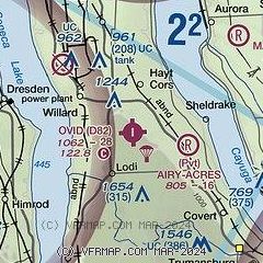
|
| Airport distance calculator |
|---|
|
|
| Sunrise and sunset |
|---|
|
Times for 11-Apr-2026
| | Local
(UTC-4) | | Zulu
(UTC) |
|---|
| Morning civil twilight | | 06:04 | | 10:04 |
| Sunrise | | 06:33 | | 10:33 |
| Sunset | | 19:43 | | 23:43 |
| Evening civil twilight | | 20:12 | | 00:12 |
|
| Current date and time |
|---|
| Zulu (UTC) | 11-Apr-2026 16:28:01 |
|---|
| Local (UTC-4) | 11-Apr-2026 12:28:01 |
|---|
|
| METAR |
|---|
KPEO
11nm W | 111553Z AUTO 33009G17KT 10SM BKN035 07/M02 A3039 RMK AO2 SLP296 T00721017
|
KITH
19nm SE | 111556Z 31011G18KT 10SM BKN033 06/M01 A3037 RMK AO2 SLPNO T00561011 PNO
|
K6B9
22nm NE | 111615Z AUTO 30008G15KT 250V330 10SM SCT030 BKN036 OVC041 06/00 A3037 RMK AO2
|
|
| TAF |
|---|
KITH
19nm SE | 111120Z 1112/1212 31011G19KT P6SM BKN015 FM111400 32010G18KT P6SM BKN025 FM111600 32010G18KT P6SM BKN035 FM111900 32012G20KT P6SM SCT150 FM112200 31007KT P6SM SCT250
|
|
| NOTAMs |
|---|
NOTAMs are issued by the DoD/FAA and will open in a separate window not controlled by AirNav.
|
|

