FAA INFORMATION EFFECTIVE 16 MAY 2024
Location
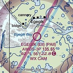
| FAA Identifier: | EII |
| Lat/Long: | 58-11-07.7650N 157-22-31.5400W
58-11.129417N 157-22.525667W
58.1854903,-157.3754278
(estimated) |
| Elevation: | 92.3 ft. / 28.1 m (surveyed) |
| Variation: | 13E (2020) |
| From city: | 2 miles S of EGEGIK, AK |
| Time zone: | UTC -8 (UTC -9 during Standard Time) |
Airport Operations
| Airport use: | Open to the public |
| Activation date: | 09/1994 |
| Control tower: | no |
| ARTCC: | ANCHORAGE CENTER |
| FSS: | KENAI FLIGHT SERVICE STATION [907-283-7211] |
| NOTAMs facility: | EII (NOTAM-D service available) |
| Attendance: | UNATNDD |
| Wind indicator: | lighted |
| Segmented circle: | yes |
| Lights: | ACTVT REIL RWY 12; PAPI RWY 12; MIRL RWY 03/21 & 12/30 - CTAF. |
| Beacon: | white-green (lighted land airport)
ACTVT ROTG BCN - CTAF. |
Airport Communications
| CTAF: | 122.8 |
| WX AWOS-3P: | 135.65 (907-233-2288) |
- APCH/DEP SVC PRVDD BY ANCHORAGE ARTCC (ZAN) ON FREQS 124.8/354.0 ( KING SALMON RCAG.)
Nearby radio navigation aids
| VOR radial/distance | | VOR name | | Freq | | Var |
|---|
| AKNr195/37.8 | | KING SALMON VORTAC | | 112.80 | | 16E |
| NDB name | | Hdg/Dist | | Freq | | Var | | ID |
|---|
| CHINOOK | | 199/38.0 | | 355 | | 11E | | AUB | .- ..- -... |
Airport Services
Runway Information
Runway 12/30
| Dimensions: | 5600 x 100 ft. / 1707 x 30 m |
| Surface: | gravel, in good condition
RWY SURFACE SOFT WHEN WET. WATER PONDING AFTER RAIN. SAFETY AREAS BEYOND THLDS AND RWY EDGES VERY SOFT. |
| Runway edge lights: | medium intensity |
| RUNWAY 12 | | RUNWAY 30 |
| Latitude: | 58-11.478167N | | 58-10.776667N |
| Longitude: | 157-23.141167W | | 157-22.015667W |
| Elevation: | 80.7 ft. | | 92.3 ft. |
| Traffic pattern: | left | | left |
| Runway heading: | 127 magnetic, 140 true | | 307 magnetic, 320 true |
| Markings: | , in fair condition | | , in fair condition |
| Visual slope indicator: | 4-light PAPI on left (3.00 degrees glide path) | | |
| Runway end identifier lights: | yes | | |
| Touchdown point: | yes, no lights | | yes, no lights |
| Obstructions: | 8 ft. brush, 245 ft. left and right of centerline | | 6 ft. brush, 245 ft. left and right of centerline |
Runway 3/21
| Dimensions: | 1500 x 75 ft. / 457 x 23 m |
| Surface: | gravel/dirt, in good condition
RWY SURFACE SOFT AFTER RAINS. SAFETY AREAS BEYOND THLDS AND RWY EDGES VERY SOFT. |
| Runway edge lights: | medium intensity |
| RUNWAY 3 | | RUNWAY 21 |
| Latitude: | 58-11.057333N | | 58-11.216500N |
| Longitude: | 157-22.506500W | | 157-22.150833W |
| Elevation: | 80.2 ft. | | 78.7 ft. |
| Traffic pattern: | left | | left |
| Runway heading: | 037 magnetic, 050 true | | 217 magnetic, 230 true |
| Touchdown point: | yes, no lights | | yes, no lights |
| Obstructions: | 7 ft. brush, 10 ft. from runway, 125 ft. left of centerline | | 2 ft. brush, 7 ft. from runway, 100 ft. left of centerline |
Airport Ownership and Management from official FAA records
| Ownership: | Publicly-owned |
| Owner: | CITY OF EGEGIK
PO BOX 189
EGEGIK, AK 99579
Phone 907-233-2400 |
| Manager: | BILL YOST
PO BOX 189
EGEGIK, AK 99579
Phone 907-233-2400 |
Airport Operational Statistics
| Aircraft operations: avg 75/month * | | 78% | air taxi | | 22% | local general aviation | | * for 12-month period ending 31 December 2020 | |
Additional Remarks
| - | WX CAMERA AVBL ON INTERNET AT HTTPS://WEATHERCAMS.FAA.GOV |
| - | RAMP AND TWYS SOFT WHEN WET. |
Instrument Procedures
NOTE: All procedures below are presented as PDF files. If you need a reader for these files, you should download the free Adobe Reader.NOT FOR NAVIGATION. Please procure official charts for flight.
FAA instrument procedures published for use from 16 May 2024 at 0901Z to 13 June 2024 at 0900z.
IAPs - Instrument Approach Procedures |
|---|
| RNAV (GPS) RWY 12 | |
download (201KB) |
| RNAV (GPS) RWY 30 | |
download (213KB) |
| NOTE: Special Take-Off Minimums/Departure Procedures apply | |
download (148KB) |
Other nearby airports with instrument procedures:
PFWS - South Naknek Nr 2 Airport (33 nm N)
PAPN - Pilot Point Airport (37 nm S)
PAKN - King Salmon Airport (37 nm NE)
PFCL - Clarks Point Airport (53 nm NW)
PADL - Dillingham Airport (62 nm NW)
|
|

Road maps at:
MapQuest
Bing
Google
| Aerial photo |
|---|

|
| Sectional chart |
|---|
|
| Airport distance calculator |
|---|
|
|
| Sunrise and sunset |
|---|
|
Times for 01-Jun-2024
| | Local
(UTC-8) | | Zulu
(UTC) |
|---|
| Morning civil twilight | | 04:25 | | 12:25 |
| Sunrise | | 05:34 | | 13:34 |
| Sunset | | 23:21 | | 07:21 |
| Evening civil twilight | | 00:30 | | 08:30 |
|
| Current date and time |
|---|
| Zulu (UTC) | 02-Jun-2024 01:59:04 |
|---|
| Local (UTC-8) | 01-Jun-2024 17:59:04 |
|---|
|
| METAR |
|---|
| PAII | 020056Z AUTO 12013KT 10SM OVC060 13/04 A2943 RMK AO2 SLP965 T01280039
|
|
| TAF |
|---|
PAKN
38nm NE | 011724Z 0118/0218 06007KT P6SM OVC050 FM012000 09012G20KT P6SM BKN035 FM020600 03006KT P6SM BKN060
|
|
| NOTAMs |
|---|
NOTAMs are issued by the DoD/FAA and will open in a separate window not controlled by AirNav.
|
|

