FAA INFORMATION EFFECTIVE 18 APRIL 2024
Location
| FAA Identifier: | EYW |
| Lat/Long: | 24-33-22.0310N 081-45-35.8410W
24-33.367183N 081-45.597350W
24.5561197,-81.7599558
(estimated) |
| Elevation: | 3.4 ft. / 1.0 m (surveyed) |
| Variation: | 04W (2000) |
| From city: | 2 miles E of KEY WEST, FL |
| Time zone: | UTC -4 (UTC -5 during Standard Time) |
| Zip code: | 33040 |
Airport Operations
| Airport use: | Open to the public |
| Activation date: | 04/1940 |
| Control tower: | yes |
| ARTCC: | MIAMI CENTER |
| FSS: | MIAMI FLIGHT SERVICE STATION |
| NOTAMs facility: | EYW (NOTAM-D service available) |
| Attendance: | 0700-2300 |
| Wind indicator: | lighted |
| Segmented circle: | yes |
| Lights: | ACTVT REIL RWY 09 & 27; PAPI RWY 09 & 27; MIRL RWY 09/27 - CTAF. |
| Beacon: | white-green (lighted land airport)
Operates sunset to sunrise. |
| Fire and rescue: | ARFF index B |
| Airline operations: | PPR FOR UNSKED ACR OPS MORE THAN 30 PAX SEATS 2330-0545 - AMGR. |
| International operations: | international airport of entry
CUST & BDR PATROL 0800-2000 MON-SAT; CLSD SUN. |
Airport Communications
| CTAF: | 118.2 |
| UNICOM: | 122.95 |
| ATIS: | 119.675 |
| WX ASOS: | PHONE 305-292-4046 |
| KEY WEST GROUND: | 121.9 [0700-2100] |
| KEY WEST TOWER: | 118.2 257.8 [0700-2100] |
| NAVY KEY WEST APPROACH: | 124.025 |
| MIAMI ARTCC APPROACH: | 126.575 |
| NAVY KEY WEST DEPARTURE: | 124.025 |
| MIAMI ARTCC DEPARTURE: | 126.575 |
| CLEARANCE DELIVERY: | 121.9 |
| EMERG: | 121.5 243.0 |
- APCH/DEP SVC PRVDD BY MIAMI ARTCC (KEY WEST RCAG) ON FREQ 133.5/306.9 WHEN NAVY KEY WEST APCH CTL CLSD.
- AIRCRAFT OVERFLYING SIMPL, ACRUZ, CANOA AND MAXIM SHALL CONTACT MIAMI ARTCC 10 MINUTES PRIOR TO CROSSING THE MIAMI FIR ON 132.2 / 323.1
Nearby radio navigation aids
| VOR radial/distance | | VOR name | | Freq | | Var |
|---|
| EYWr128/2.8 | | KEY WEST VORTAC | | 113.50 | | 01E |
| NDB name | | Hdg/Dist | | Freq | | Var | | ID |
|---|
| FISH HOOK | | 076/1.5 | | 332 | | 04W | | FIS | ..-. .. ... |
| MARATHON | | 260/37.4 | | 260 | | 04W | | MTH | -- - .... |
Airport Services
| Fuel available: | 100LL JET-A |
| Parking: | tiedowns |
| Airframe service: | MAJOR |
| Powerplant service: | MAJOR |
| Bottled oxygen: | LOW |
| Bulk oxygen: | NONE |
Runway Information
Runway 9/27
| Dimensions: | 5076 x 100 ft. / 1547 x 30 m |
| Surface: | asphalt/grooved, in excellent condition |
| Weight bearing capacity: | | PCN 42 /F/A/W/T | | Single wheel: | 75.0 | | Double wheel: | 125.0 | | Double tandem: | 195.0 |
|
| Runway edge lights: | medium intensity |
| RUNWAY 9 | | RUNWAY 27 |
| Latitude: | 24-33.362742N | | 24-33.371602N |
| Longitude: | 081-46.055460W | | 081-45.139255W |
| Elevation: | 3.2 ft. | | 2.5 ft. |
| Traffic pattern: | right | | left |
| Runway heading: | 093 magnetic, 089 true | | 273 magnetic, 269 true |
| Displaced threshold: | 275 ft. | | no |
| Declared distances: | TORA:5075 TODA:5075 ASDA:5075 LDA:4801 | | TORA:4801 TODA:4801 ASDA:4801 LDA:4801 |
| Markings: | nonprecision, in fair condition | | nonprecision, in fair condition |
| Visual slope indicator: | 4-light PAPI on left (3.00 degrees glide path) | | 4-light PAPI on right (3.00 degrees glide path) |
| Runway end identifier lights: | yes | | yes |
| Touchdown point: | yes, no lights | | yes, no lights |
| Obstructions: | 22 ft. tree, 745 ft. from runway, 200 ft. left of centerline, 24:1 slope to clear
RWY 09 APRCH SLP 46:1 TO MKD DSPLCD THR. | | 10 ft. brush, 555 ft. from runway, 260 ft. left of centerline, 34:1 slope to clear |
Airport Ownership and Management from official FAA records
| Ownership: | Publicly-owned |
| Owner: | MONROE COUNTY
3491 S ROOSEVELT BLVD
KEY WEST, FL 33040-5260
Phone 305-809-5200 |
| Manager: | RICHARD STRICKLAND
3491 S ROOSEVELT BLVD
KEY WEST, FL 33040-5260
Phone 305-809-5200 |
Airport Operational Statistics
| Aircraft based on the field: | | 56 | | Single engine airplanes: | | 37 | | Multi engine airplanes: | | 13 | | Jet airplanes: | | 3 | | Helicopters: | | 2 | | Ultralights: | | 1 |
| |  | |
| Aircraft operations: avg 160/day * | | 54% | transient general aviation | | 29% | commercial | | 12% | air taxi | | 4% | local general aviation | | <1% | military | | * for 12-month period ending 31 December 2023 | |
Additional Remarks
| E60-27 | ENGRD MTRLS ARSTG SYS (EMAS) 274 FT IN LEN BY 122 FT IN WID LCTD 307 FT FM THR OF THE DER 27. |
| E60-09 | ENGRD MTRLS ARSTG SYS (EMAS) 340 FT IN LEN BY 120 FT IN WID LCTD AT THE DER 09. |
| - | BIRDS ON & INVOF ARPT. |
| - | R-2916 LCTD 14 NM NE OF ARPT HAS STROBE LGT, MKD BLN & CABLE TO 14000 FT. |
| - | MIL JET TFC S & E OF ARPT; ACFT ENTERING TFC AREA FM SE THRU W. |
| - | ENTER TFC AREA BLW 2000 FT; REFER TO MIAMI VFR TAC FOR SUG VFR FLYWAY RTES. |
| - | NOISE SENSITIVE AREA; USE NBAA NOISE ABATEMENT PROC OTR TIMES; ENG RUNUPS IN DSGND AREA ON TWY A BTN TWY B10 & TWY B11; NO OPS 2300-0700 . |
| - | PPR FOR WINGSPAN MORE THAN 118 FT OR EXCEEDING RWY WT BRG CPTY - AMGR. |
| - | VFR DEP MNTN RWY HDG TIL RCHG FLD BOUNDARY THEN EXACT TURN N OR S. |
| - | TWY B5 NOT VSB FM ATCT. |
| - | FOR CD IF UNA TO CTC ON FSS FREQ, CTC MIAMI ARTCC AT 305-716-1731. |
Instrument Procedures
NOTE: All procedures below are presented as PDF files. If you need a reader for these files, you should download the free Adobe Reader.NOT FOR NAVIGATION. Please procure official charts for flight.
FAA instrument procedures published for use from 18 April 2024 at 0901Z to 16 May 2024 at 0900Z.
IAPs - Instrument Approach Procedures |
|---|
| RNAV (GPS) RWY 09 **CHANGED** | |
download (245KB) |
| RNAV (GPS) RWY 27 **CHANGED** | |
download (223KB) |
| NDB-A **CHANGED** | |
download (184KB) |
| NOTE: Special Alternate Minimums apply **CHANGED** | |
download (148KB) |
| NOTE: Special Take-Off Minimums/Departure Procedures apply | |
download (162KB) |
Other nearby airports with instrument procedures:
KNQX - Key West Naval Air Station (Boca Chica Field) Airport (4 nm E)
KMTH - The Florida Keys Marathon International Airport (40 nm E)
KMKY - Marco Island Executive Airport (86 nm N)
X51 - Miami Homestead General Aviation Airport (87 nm NE)
KTNT - Dade-Collier Training and Transition Airport (91 nm NE)
|
|

Road maps at:
MapQuest
Bing
Google
| Aerial photo |
|---|
WARNING: Photo may not be current or correct
 Photo by William C Harris
Photo taken 12-Aug-2017
looking east.
Photo by William C Harris
Photo taken 12-Aug-2017
looking east.
Do you have a better or more recent aerial photo of Key West International Airport that you would like to share? If so, please send us your photo.
|
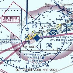
| Sectional chart |
|---|
|
 Download PDF
of official airport diagram from the FAA
| Airport distance calculator |
|---|
|
|
| Sunrise and sunset |
|---|
|
Times for 20-Apr-2024
| | Local
(UTC-4) | | Zulu
(UTC) |
|---|
| Morning civil twilight | | 06:37 | | 10:37 |
| Sunrise | | 07:01 | | 11:01 |
| Sunset | | 19:51 | | 23:51 |
| Evening civil twilight | | 20:14 | | 00:14 |
|
| Current date and time |
|---|
| Zulu (UTC) | 20-Apr-2024 05:24:07 |
|---|
| Local (UTC-4) | 20-Apr-2024 01:24:07 |
|---|
|
| METAR |
|---|
| KEYW | 200453Z AUTO 08006KT 10SM CLR 24/21 A3007 RMK AO2 SLP187 T02440206 402890239 $
|
KNQX
5nm E | 200453Z AUTO 09008KT CLR 24/22 A3006 RMK AO2 SLP179 T02440217 403060239 $
|
|
| TAF |
|---|
| KEYW | 191745Z 1918/2018 11009KT P6SM FEW020
|
KNQX
5nm E | 1923/2023 12008KT 9999 FEW020 SCT250 QNH2998INS FM201400 13011KT 9999 FEW020 QNH2996INS AUTOMATED SENSOR METWATCH 2002 TIL 2010 TX31/2019Z TN24/2011Z FN20056
|
|
| NOTAMs |
|---|
NOTAMs are issued by the DoD/FAA and will open in a separate window not controlled by AirNav.
|
|


